
Urmatt
| Urmatt | ||
|---|---|---|

|
|
|
| region | Grand Est | |
| Department | Bas-Rhin | |
| Arrondissement | Molsheim | |
| Canton | Dirty | |
| Community association | Vallée de la Bruche | |
| Coordinates | 48 ° 32 ' N , 7 ° 20' E | |
| height | 224-900 m | |
| surface | 13.83 km 2 | |
| Residents | 1,478 (January 1, 2017) | |
| Population density | 107 inhabitants / km 2 | |
| Post Code | 67280 | |
| INSEE code | 67500 | |
| Website | http://www.mairie-urmatt.fr | |

Urmatt is a French commune with 1,478 inhabitants (as of January 1, 2017) in the Breusch valley in the Bas-Rhin department in the Grand Est region (until 2015 Alsace ). In the time of the Merovingians the place was called "Casa Rumaldi". On the Langenberg, a secondary peak of the Rocher de Mutzig , there is a Druid monument .
Population development
| 1962 | 1968 | 1975 | 1982 | 1990 | 1999 | 2008 | 2017 |
|---|---|---|---|---|---|---|---|
| 980 | 1042 | 1092 | 1121 | 1243 | 1357 | 1447 | 1478 |
coat of arms
According to the Alsatian historian Grandidier, the name Urmatt (Latin urus) goes back to the word source. According to his interpretation, a perfect place to hunt aurochs in trenches on wet swampy terrain. Another historian Schoepflin interprets UR as old and MAT as meadow, hence old meadows . The coat of arms shows a red aurochs on a green background.
Attractions
- Großer Katzenberg (967 m) with the remains of the château de la muraille
- Old well from the defunct Dominican monastery
- Sainte-Croix church and chapel (1828)
- Natural monument Porte de pierre / Türangel: two weathered vertical sandstone rocks, on which another sandstone rock lies like a lintel
- Usine Mullerhof: Henry Müller from nearby Schirmeck bought in 1840 a mill near Urmatt and installed there a spinning loom: he also built a castle-like property that for him Château du Mullerhof called

Mairie

Community center
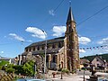
Sainte-Croix church

Choir of the church


literature
- Le Patrimoine des Communes du Bas-Rhin . Flohic Editions, Volume 1, Charenton-le-Pont 1999, ISBN 2-84234-055-8 , pp. 778-782.