Meurthe
| Meurthe | ||
|
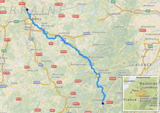
Course of the Meurthe ( interactive map ) |
||
| Data | ||
| Water code | FR : A6-0100 | |
| location |
Vosges
|
|
| River system | Rhine | |
| Drain over | Moselle → Rhine → North Sea | |
| source | in the Vosges in the municipality of Le Valtin, 48 ° 3 ′ 25 ″ N , 7 ° 0 ′ 50 ″ E |
|
| Source height | approx. 1185 m | |
| muzzle | north of Nancy in the Moselle Coordinates: 48 ° 46 ′ 48 ″ N , 6 ° 8 ′ 30 ″ E 48 ° 46 ′ 48 ″ N , 6 ° 8 ′ 30 ″ E |
|
| Mouth height | approx. 189 m | |
| Height difference | approx. 996 m | |
| Bottom slope | approx. 6.2 ‰ | |
| length | approx. 160 km | |
| Catchment area | 3,085.4 km² | |
| Drain at the mouth |
MQ |
41.1 m³ / s |
| Left tributaries | Petite Meurthe , Mortagne | |
| Right tributaries | Amezule , Fave , Plaine , Rabodeau , Sânon , Vezouze | |
| Big cities | Nancy | |
| Medium-sized cities | Saint-Dié-des-Vosges , Lunéville | |
| Small towns | Dombasle-sur-Meurthe , Raon-l'Étape | |
|
The Meurthe in Saint-Dié |
||
The Meurthe ( Celtic Murta , old German: Mörta , German Mörthe ) is a river in France that runs in the Grand Est region . With an average discharge of over 40 m³ / s, it is the third largest tributary of the Moselle .
geography
course
The source of the Meurthe is located in the Vosges in the north of the Hohneck massif near the west saddle of the Col de la Schlucht and on the Route des Crêtes in the municipality of Le Valtin .
It initially follows the large longitudinal valley west of the Vosges main ridge with the Route des Crêtes to the northeast and then generally flows in a north-westerly direction through the Lorraine plain . After 160 kilometers, it flows north of Nancy at the Gueule d'Enfer (municipal boundary between Frouard and Custines ) as a right tributary into the Moselle . The Moselle swings abruptly in the direction of the Meurthe. The Meurthe was once the upper reaches of the Moselle until it diverted the upper Maas during the Saale Ice Age around 250,000 years ago and made it today's own upper course.
The Canal de la Marne au Rhin accompanies the river between Dombasle-sur-Meurthe and the estuary . The catchment area comprises the middle third of the western Vosges region and extends over 3085 km². On its way, the Meurthe crosses the Vosges and Meurthe-et-Moselle departments .
Places on the river
- Le Valtin
- Fraize (German Freß )
- Saint-Dié-des-Vosges (German Sankt Diedeln or Sankt Didel )
- Raon-l'Étape (German Raon am Zoll )
- Baccarat (German Burgamberg )
- Lunéville (German Lünestadt )
- Dombasle-sur-Meurthe (German: Dombasel an der Mörthe )
- Nancy (German: Nanzig )
Cultural history
The Meurthe from Raon-l'Étape was used for rafting until the 19th century . The closest customer for the wood was the Baccarat crystal works , but the logs were sometimes also delivered by water to Metz and Thionville . The former French department of Meurthe was named after the river and has now merged into what is now the department of Meurthe-et-Moselle.
See also
Web links
- Meurthe at SANDRE (French)
- Agence de l'eau Rhin-Meuse: Débits caractéristiques en M3 / S (1971–1990). (pdf, 28 kB) April 15, 2003 (French).


