Fraize
| Fraize | ||
|---|---|---|

|
|
|
| region | Grand Est | |
| Department | Vosges | |
| Arrondissement | Saint-Dié-des-Vosges | |
| Canton | Gerardmer | |
| Community association | Saint-Dié-des-Vosges | |
| Coordinates | 48 ° 11 ′ N , 7 ° 0 ′ E | |
| height | 468-1,131 m | |
| surface | 15.59 km 2 | |
| Residents | 2,871 (January 1, 2017) | |
| Population density | 184 inhabitants / km 2 | |
| Post Code | 88230 | |
| INSEE code | 88181 | |
| Website | http://www.ville-fraize.fr/ | |
 Location of the commune of Fraize in the Vosges department |
||
Fraize is a French commune with 2871 inhabitants (as of January 1, 2017) in the Vosges department in the Grand Est region . It belongs to the Arrondissement of Saint-Dié-des-Vosges and the municipality of Saint-Dié-des-Vosges .
geography
The small town of Fraize is located in the Vosges , in the valley of the upper Meurthe . It is about 15 kilometers from Saint-Dié-des-Vosges , the capital (chef-lieu) of the arrondissement of the same name. The eastern municipal border runs along the Vosges ridge and also forms the border with the Alsace region . The Meurthe flows through the municipality from southeast to west and takes in several small mountain streams, including the Ruisseau de Scarupt , whose five kilometer long valley occupies the east of the municipality. The highest point in the municipality of Fraize is the 1128 m high Rossberg ( le Rossberg ) on the border with Alsace.
The territory of the municipality of Fraize is part of the Ballons des Vosges Regional Nature Park ( Parc Naturel Régional des Ballons des Vosges ).
Half of the 15.59 km² large municipality of Fraizes (8.03 km²) is made up of forests ( Forêt communale de Fraize ) that extend to the ridge of the Vosges. In the lower-lying areas there is pastureland, and economic arable farming is only possible to a limited extent due to the altitude.
Fraize includes the districts of Les Aulnes, Les Ponsez and Scarupt .
Fraize neighbors are Mandray in the north, La Croix-aux-Mines in the northeast, Le Bonhomme in the east, Plainfaing in the south, Ban-sur-Meurthe-Clefcy in the southwest and Anould in the west.
history
For a long time, the derivation from the Latin fraxinus ( ash ) was considered the origin for the name Fraize (earlier spellings: Fracia, Fraic ) - the inhabitants still call themselves Fraxiniens today . Linguists have been interpreting the origin of the place name from the Latin term fractura (break) as a landscape form since the 20th century .
When the empire of Charlemagne was divided in 843 ( Treaty of Verdun ), the area of the Bannes Fraize became part of the Middle Kingdom , and after various partitions it became the Duchy of Lorraine .
From 1221 the rulership of the area around Fraize changed before it fell back to the Dukes of Lorraine from 1343 to 1766 . Fraize and Plainfaing were created in 1783 from the Fraize spell, which included many scattered hamlets .
As in other Vosges valleys, the textile industry found its way into Fraize from the middle of the 19th century. Many textile companies in the area closed in the 1970s and 1980s, only Shemsy SA , a sportswear manufacturer, still produces in Fraize today.
Population development
The effects of the decline of the textile industry can also be seen in the development of the population of Fraize.
| 1962 | 1968 | 1975 | 1982 | 1990 | 1999 | 2006 | 2017 | ||
| 3356 | 3486 | 3367 | 3357 | 3049 | 2990 | 3057 | 2871 | ||
| Sources: Cassini and INSEE | |||||||||
Attractions
- Saint-Blaise church, built at the end of the 18th century
- Town hall, built in 1858
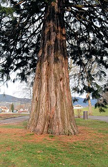
- Giant sequoia
- 16th century courtyard called "la Cour" (Court of Justice)
Economy and Infrastructure
19 farms are located in Fraize (potato and vegetable cultivation, dairy farming, breeding of cattle, horses and poultry). Cheese making and the distilling of fruit schnapps ( eau de vie ) are also worth mentioning . Due to the abundance of forests in the upper Vosges, forestry has a long tradition. Fraize has several factories in two business parks, whose products include furniture, car accessories and sportswear.
In addition to a kindergarten, Fraize has a primary school ( Ecole Primaire ) and the Collège de la Haute-Meurthe .
Fraize is on Route nationale 415 , which runs from Saint-Dié-des-Vosges via the nearby Col du Bonhomme and Colmar to Breisach am Rhein . From Fraize, the D 23 trunk road leads over the 690 m high Col de Mandray to the northeastern neighboring communities. The street name Impasse de la Gare still reminds of the railway line from Saint-Dié to Fraize, which opened in 1873 and finally closed in 1993 .
Personalities
- Raymond Voinquel (1912–1994), French photographer


