La Bresse
| La Bresse | ||
|---|---|---|

|
|
|
| region | Grand Est | |
| Department | Vosges | |
| Arrondissement | Saint-Dié-des-Vosges | |
| Canton | La Bresse (main town) | |
| Community association | Hautes Vosges | |
| Coordinates | 48 ° 0 ′ N , 6 ° 53 ′ E | |
| height | 580-1,363 m | |
| surface | 57.94 km 2 | |
| Residents | 4,154 (January 1, 2017) | |
| Population density | 72 inhabitants / km 2 | |
| Post Code | 88250 | |
| INSEE code | 88075 | |
| Website | www.labresse.fr | |
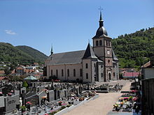
 La Bresse Town Hall |
||
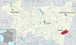
La Bresse ( German wool ) is a French commune with 4154 inhabitants (as of January 1, 2017) in the Vosges department in the Grand Est region (until 2015 Lorraine ). It belongs to the arrondissement of Saint-Dié-des-Vosges and is the capital of the canton of La Bresse formed on January 1, 2015 . With 57.94 km², La Bresse is the third largest municipality by area in the Vosges department.
geography
La Bresse is located west of the Vosges ridge in the upper valley of the Moselotte at the foot of the 1363 m high Hohneck , about 15 kilometers from Gérardmer . The place can be reached from Colmar, 54 km away, via the Col de la Schlucht , from Mulhouse, 60 km away, via the Col d'Oderen or the Col de Bramont, or from Épinal, 57 km away, via the Col de Grosse Pierre .
Neighboring municipalities of La Bresse are Gérardmer in the north, Xonrupt-Longemer and Stosswihr in the northeast, Metzeral in the east, Wildenstein in the southeast, Cornimont in the south, Basse-sur-le-Rupt in the west and Rochesson in the northwest.
Younger story
The place was less affected by the consequences of the First World War than the areas east of the Vosges ridge (Col d 'Armand - Hartmannsweiler Kopf , Collet du Linge - Lingenkopf and Hohrodberg). Towards the end of the Second World War, however, partisans of the retreating German army made trouble above La Bresse . Due to an order from General Hermann Balck , the place was systematically destroyed by the German Wehrmacht in November 1944 and the male residents were deported to a camp near Pforzheim for forced labor . Some of the men in this camp were then victims of an Allied bombing raid. The partisans who the Wehrmacht got hold of were executed above the town. General Balck was sentenced in absentia to 20 years of forced labor by a French military tribunal after the war.
| year | 1962 | 1968 | 1975 | 1982 | 1990 | 1999 | 2007 | 2017 |
| Residents | 4980 | 5290 | 5395 | 5369 | 5191 | 4928 | 4700 | 4154 |
economy
tourism
Sports tourism is an essential source of economic activity: the municipality's largest ski area in the Vosges (La Bresse-Hoheneck) with over 20 lifts and two smaller ski areas with 3 - 4 lifts and several cross-country trails . In summer there are mountain bike offers (Trace Vosgienne), a forest ropes course , a trial motorcycle school and a paragliding school . There are bathing opportunities at Lac des Corbeaux and Lac de Blanchmer. The Lac de Lispach, which lies in the middle of a high moor, is interesting in terms of landscape. The municipality is part of the Ballons des Vosges Regional Nature Park . In La Bresse there are numerous shops, restaurants and street cafes as well as a cinema.
Other branches of industry
There are smaller industries, such as granite processing and window manufacturing. The Agriculture and Forestry is another source of income.
partnership
There is a city partnership with Ménaka in Mali . There are also friendly relations with the German city of Pforzheim in Baden-Württemberg and the Belgian city of Durbuy in Wallonia .
Born in La Bresse
- Gilbert Poirot (1944–2012), ski jumper
- Gérard Colin (* 1958), ski jumper
Web links
Individual evidence
- ↑ Scorched Earth on gedenkorte-europa.eu, the homepage of Gedenkorte Europa 1939–1945 , accessed May 29, 2015


