Liézey
| Liézey | ||
|---|---|---|

|
|
|
| region | Grand Est | |
| Department | Vosges | |
| Arrondissement | Saint-Dié-des-Vosges | |
| Canton | Gerardmer | |
| Community association | Hautes Vosges | |
| Coordinates | 48 ° 6 ′ N , 6 ° 48 ′ E | |
| height | 584-923 m | |
| surface | 13.27 km 2 | |
| Residents | 286 (January 1, 2017) | |
| Population density | 22 inhabitants / km 2 | |
| Post Code | 88400 | |
| INSEE code | 88269 | |
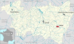
 Location of the municipality of Liézey in the Vosges department |
||
Liézey is a French commune with 286 inhabitants (as of January 1, 2017) in the Vosges department of the Grand Est region (until 2015 Lorraine ). It belongs to the Arrondissement of Saint-Dié-des-Vosges and the Hautes Vosges municipal association .
geography
The municipality of Liézey is located in the Vosges , about eight kilometers west of the city of Gérardmer .
The 13.27 km² municipal area of Liézey extends over the catchment area of the mountain stream of the same name ( Ruisseau de Liézey ), which flows over the Cleurie into the Moselle . In contrast , the district of La Racine in the west of the municipality lies in the headwaters of the Barba , a left tributary of the Vologne . The church and town hall ( Mairie ) form the core of the scattered Liézey settlement. The town hall, located 750 meters above sea level, is the highest in the Vosges department. The elevations flanking the Liézeytal reach 825 m above sea level in the west and a maximum of 923 m in the extreme south-east.
More than half of the community area is covered by coniferous forests. These are shares in the large contiguous forests Forêt Domaniale de Vologne in the north and Forêt de Rounimont in the southeast of the municipality. The altitude of the valley locations of over 600 meters means that there is hardly any economic arable farming, so cattle pastures dominate in the valley and on the lower slopes. There are also individual mountain farms in the higher elevations.
Neighboring municipalities of Liézey are Granges-sur-Vologne in the north, Gérardmer in the east and south, Le Tholy in the west and Rehaupal and Champdray in the north-west.
history
The Saint-Nicolas church is one of the few churches in France that was built during the French Revolution. Its construction was completed in 1795 with the significant participation of the population. The church and the construction of the schoolhouse in 1820 (today the town hall) enabled the foundation of the independent municipality of Liézey from parts of the municipal areas of Gérardmer , Champdray and Granges-sur-Vologne in 1836 .
The residents of Liézey call themselves Pouhas , which is due to the tradition of obtaining poix ( pitch ) from the resin of beech and birch trees in the dense forests in the area.
Population development
| year | 1962 | 1968 | 1975 | 1982 | 1990 | 1999 | 2007 | 2017 | |
| Residents | 172 | 217 | 169 | 245 | 298 | 320 | 288 | 286 | |
| Sources: Cassini and INSEE | |||||||||
The population figures show that Liézey benefited from the boom in tourism on the nearby Lac de Gérardmer in the second half of the 20th century , when numerous guest houses and holiday homes were built in the municipality.
Attractions
- Saint-Nicolas church, built between 1792 and 1795
- Museum La maison de l'artisanat (House of Crafts), housed in an old farmhouse, Sundays open to visitors
- Grandemange farm (cheese-making, open to visitors)
- Seven wayside crosses in the territory of the commune: Croix sur l'enceinte du cimetière, Croix en fer forgé Nicolas Georgel (1796), Croix de Blanchefontaine (1721), Croix de Ménaumont (1760), Croix du Page (1807), Croix Délon (1729 ), Croix de Saucéfaing (1806)
Economy and Infrastructure
Liézey is now a tourist town with numerous guest houses and holiday homes. The municipality owes this development to its location near the waterfalls of Tendon and the Lac de Gérardmer as well as the convenient transport links to the city of Gérardmer . Eleven farms are located in the municipality of Liézey (dairy farming, cattle, pig and poultry breeding, beekeeping).
Liézey is two kilometers from the departmental road 417 ( Remiremont - Gérardmer - Colmar ) that crosses the Vosges . There are also road connections to the neighboring communities in the north of Rehaupal , Champdray and Granges-sur-Vologne . The nearest train station is in the town of Remiremont, 20 kilometers away.


