
Vologne
| Vologne | ||
 Catchment area of the Vologne |
||
| Data | ||
| Water code | FR : A43-0200 | |
| location |
France
|
|
| River system | Rhine | |
| Drain over | Moselle → Rhine → North Sea | |
| source |
Vosges , south of the Col de la Schlucht 48 ° 3 ′ 3 ″ N , 7 ° 0 ′ 44 ″ E |
|
| Source height | approx. 1220 m | |
| muzzle | at Jarménil in the Moselle Coordinates: 48 ° 6 ′ 50 ″ N , 6 ° 34 ′ 1 ″ E 48 ° 6 ′ 50 ″ N , 6 ° 34 ′ 1 ″ E |
|
| Mouth height | approx. 350 m | |
| Height difference | approx. 870 m | |
| Bottom slope | approx. 17 ‰ | |
| length | 50 km (see notes) | |
| Catchment area | 369 km² | |
| Drain at the mouth |
MQ |
9.65 m³ / s |
| Flowing lakes | Lac de Retournemer , Lac de Longemer | |
| Small towns | Gerardmer | |
 Vologne at Deycimont |
||
 Volognebrücke (Pont des Fées) near Gérardmer |
||
 Lac de Longemer |
||
The Vologne is a river in France that runs in the Vosges department .
geography
course
The Vologne rises in the Vosges , south of the Col de la Schlucht , in the municipality of Xonrupt-Longemer . It generally drains to the west and flows 50 kilometers into Jarménil , south of Épinal , as a right tributary into the Moselle .
Tributaries
- Belbriette ( right ), 3.7 miles
- Narouël ( right ), 1.5 miles
- Jamagne ( left ), 4.3 miles
- Corbeline ( right ), 9.4 km
- Bas Prés ( left ), 8.6 km
- Clous ( left ), 3.6 km
- Neuné ( right ), 15 miles
- Lizerne ( right ), 3.6 km
- Cul d'Honstot ( right ), 2.5 km
- Malenrupt ( left ), 3.4 km
- Barba ( left ), 9.7 miles
Places on the river
Hydrology
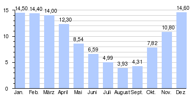
At the confluence of the Vologne in the Moselle , the mean flow rate (MQ) is 9.65 m³ / s; the catchment area here covers 369 km². At the Cheniménil gauge, the average annual runoff of the Vologne was calculated over a period of 41 years (1969–2009) . The catchment area at this point corresponds to about 355 km² with about 96.2% of the complete catchment area of the river.
The highest water levels are measured in the winter months from December to April. The flow rate reached its peak in December at 14.6 m³ / s. From May onwards, the discharge falls noticeably month after month and reaches its lowest level in August with 3.93 m³ / s, after which it increases again from month to month.
The monthly mean discharge (MQ) of the Vologne in m³ / s,
measured at the Cheniménil hydrological station.
Data calculated from the values for the years 1969–2009
See also
Web links
- Débits caractéristiques de la Vologne (French; PDF file; 14 kB)
Individual evidence
- ↑ a b geoportail.fr (1: 16,000)
- ↑ a b Web link: Débits caractéristiques de la Vologne
- ↑ The information on the length of the river is based on the information on the Vologne from SANDRE (French), accessed on October 4, 2010, rounded to full kilometers.
- ↑ Banque Hydro - Station A4362030 - La Vologne à Cheniménil (menu item: Synthèse)