
Col de la Schlucht
| Col de la Schlucht | |||
|---|---|---|---|
 Last snow in March |
|||
| Compass direction | west | east | |
| Pass height | 1139 m | ||
| Department | Vosges | Haut-Rhin | |
| Watershed | Vologne | Fencing | |
| Valley locations | Xonrupt-Longemer | Soultzeren | |
| expansion | paved road | ||
| Built | 1858-1861 | 1840-1845 | |
| Lock | Regular winter service (ski station) | ||
| Mountains | Vosges Hohneck massif | ||
| profile | |||
| Mountain scoring | 2nd category (Tour de France 2014) | ||
| Ø pitch | 3.2% (412 m / 9.8 km) | 4.2% (? M / 18 km) | |
| Max. Incline | 7.4% (on km 4 - 4.5) | 5.3% | |
| map | |||
|
|||
| Coordinates | 48 ° 3 '50 " N , 7 ° 1' 22" E | ||

The Col de la Schlucht (German: Schluchtpass ) is a 1139 m high pass in the Vosges and an important traffic axis between the regions of Alsace and Lorraine . The Col de la Schlucht is also eponymous for a ski area below the 1362 m high Hohneck .
location
In the transport network
The country road D 417 ( Route départementale 417) over the Col de la Schlucht connects the cities of Munster in the east and Gérardmer in the west. At the Col de la Schlucht, the pass road crosses the Route des Crêtes , a 77 km long high-altitude road that runs from Lac Blanc to Cernay and always moves at an altitude of around 1000 meters. Furthermore, the D 61 joins the pass from the north and the D 430 joins the D 417 a few hundred meters west of the pass from the south.
The source of the Meurthe is located one kilometer southwest of the pass on the Route des Crêtes .
On a cultural, religious and linguistic border
The Col de la Schlucht is like most passes in the High Vosges first a very old border between the Duchy of Lorraine and the fragmented Landgraviate Alsace. The direct eastern neighbors were the imperial abbey and the imperial city of Münster in the Gregoriental , which were subject to the bailiff of Hagenau and enjoyed imperial immediacy, so that the Duke of Lorraine, the imperial abbot and the envoy of the valley community could meet in various colleges at the imperial days.
With the introduction of the Reformation in the Münstertal, despite the patronage of the Benedictine abbots, the Vosges passports in this region represented less of a transition point than a clear, sometimes desirable dividing line between two culturally and spiritually contrasting communities that had long been difficult to reconcile. Closely connected with this was the millennia-old language border that separates the Alemannic language area from the Romance language area in the west. If you passed the Col de la Schlucht from west to east, you came to a German-speaking Lutheran country with close ties to the Alpine countries, including Switzerland and western Austria. Today, with the sharp decline in regional dialect and religious practice, this culture shock can hardly be felt, even if the architectural landscapes on both sides are reminiscent of two clearly differentiated cultural communities.
The top of the pass formed the border between France and the German Reich from 1871 to 1918 , and provisionally again between 1940 and 1945. Today the pass is in the Lorraine community of Le Valtin in the canton of Fraize and separates the regions of Lorraine and Alsace .
history
Construction of the first street


This pass has only been used for through traffic since 1857, after a road was built between Soultzeren and the Collet, later extended to Gérardmer . It was actually a not easy to pass bottleneck on the ridge line of the High Vosges, whose access was only possible with the more modern technology of the 19th century on steep rocky valley flanks and mountain ridges. Other more easily accessible, albeit steep, passes have been used on the ridge in the Münsterer Land in connection with the Lorraine flank of the Vosges since the Middle Ages with a mule track such as the Col de Calvaire, the Col de Falimont or the Col du Herrenberg.
As the name clearly suggests, the pass was initially a narrow gorge away from any traffic or trade routes or routes. There used to be only smugglers and timber trucks with their horn sledges . The people of Minster had to haul the wood that they had cut down below the ravine around the Retournemer lake on serpentine paths and from there, because of the steep rocky slopes on the Alsatian side, to carry it down with the horn sledges.
The Gregoriental had long ceased to be a territory of the Holy Roman Empire when the industrial revolution began in Münster, especially thanks to the entrepreneurial spirit of the Hartmann family from Colmar . The construction of a road, including the Münster-Schlucht cog railway, is actually due to the local Hartmann entrepreneurial dynasty, who decisively helped the Münstertal to a technical and economic boom in the field of the textile industry, wood processing and the energy sector.
Voltaire stayed in this new Munster valley for a year in 1754 without attracting any attention. He enjoyed the anonymity and the simplicity of life at that time in the hamlet of Luttenbach-Fortschwihr.
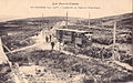
Two mountain railways meet at the gorge
The development of this mountain area , which was previously perceived as a barrier and dividing line, was also of significance in terms of railway history , with a mountain railway line that was inaugurated on the Lorraine, i.e. French side, in 1903 to connect Gérardmer with the Hohneck . This railway line existed until 1939 and had a stop at the gorge, the starting point for numerous hikes. A second mountain railway line was opened in 1907 on the Alsatian or at that time imperial German side between Munster and the Col de la Schlucht, but closed in 1914. Both mountain railways could not survive the two world wars.

La Schlucht stop of the mountain railway and hotel
At the foot of the Hohneck - arrival of the mountain railway, known as the tramway

La Schlucht - Grande Tranchée

Stop at the Saut des Cuves waterfall

Schlucht Tramway - ascent to the Hohneck

Munster-Tramway Krappenfels-Tunnel, at Col de la Schlucht


The Altenberg sanatorium hotel

.jpg)
Not far from the Col de la Schlucht on the Alsatian side, the Altenberg sanatorium and wellness hotel, founded in 1896 and closed on September 30, 2011 as the now decrepit Center médico-social , welcomed well-known spa guests such as Wilhelm II , Queen of the Netherlands Wilhelmina , British Prime Minister Lord Robert Cecil and French President Raymond Poincaré .
The Baedeker Handbook for Travelers Germany in a volume from 1906 describes the spa hotel as a Swiss-style house (“chalet”) on German soil and a good economy .
The alternative long-distance hiking trail of the GR 5
The alternative GR 5 , a red rectangle with a white stripe in the middle, goes along the ridge line and therefore leads from peak to peak with a view of the Lorraine and Alsatian sides. Instead of walking down to Mittlach, you can reach the GR 5 again at Col de Herrenberg by staying on First.

Course of the alternative GR 5
- Hohneck (1363 m)
- Kastelberg (1350 m)
- Rainkopf (1305 m)
- Rothenbachkopf (1316 m)
- Battery head (1311 m)
- Col du Herrenberg (here crosses the classic GR 5)
Belvédère du Spitzenfels viewpoint and other destinations
- Almost 1 km east of the D 417 there is the Belvédère du Spitzenfels vantage point , from which one has a comprehensive view of the Sentier des Roches via ferrata and the three highest mountains in the Vosges, namely the Großer Belchen in the south-southeast in around 20 Kilometers away, a little to the west of it at approximately the same distance the Storkenkopf and in the south-southwest at about four kilometers the Hohneck .
- To the east of Col de la Schlucht, on the D 61, is the “Auberge Gazon du Faing” restaurant at an altitude of 1,300 m, between Lac Blanc and Col de la Schlucht. (Tel. 03 29 63 42 44 - 03 89 71 20 38) ( location )
- Between this point and the Col de la Schlucht lies the Lac vert , which good hikers can reach on a winding path around 1,000 m away from the D 61.

Location coordinates: 48 ° 3 ′ 52.2 ″ N , 7 ° 1 ′ 57 ″ E
Tour de France
The Col de la Schlucht was ridden by the Tour de France in 1931, 1957, 1961, 1969, 1970, 1973, 1992, 2005, 2009 and 2014 .
In the literature
The 1931 novel Das Gasthaus im Alsace ( Le Relais d'Alsace ) by Georges Simenon is set in a fictional inn at Col de la Schlucht.
Web links
Sources and individual references
- Alban Fournier, Les Vosges du Donon Au Ballon d'Alsace , Est Libris, 1994, Chapter V, Part IV (fr) (reproduction of the first edition from 1901, Louis Geisler, Raon-L'Etape)
- ↑ See e.g. B. Homepage "On the trail of the Protestant cultural heritage in Alsace", Rundwege, (de) [1]
- ↑ See main article about the imperial city of Münster
- ↑ Alban Fournier, Les Vosges du Donon Au Ballon d'Alsace , EST Libris, 1994, 539 pages, p. 403, 5th part, chap. 4th
- ↑ Official homepage of the municipality of Munster (de) [2]
- ↑ Alban Fournier, Les Vosges du Donon au Ballon d'Alsace , Est Libris, 1994, pp. 413-417
- ↑ Is mentioned in Baedeker from 1942: "The Alsace, Strasbourg and the Vosges: Travel Guide", Baedeker, Karl, Leipzig, 1942 - 192 pages - page 126
- ↑ Article on the website of the TV channel FRANCE 3 [3] (fr)
- ↑ article in the newspaper L'ALSACE from September 6, 2011
- ^ Official homepage of the Munster community
- ↑ Germany in one volume: Handbook for travelers, Verlag von Karl Baedeker, 1906 - 452 pages
- ↑ stages 9-13. July 2014 - Gérardmer - Mulhouse - 166 km - 6 passes