
Sentier des Roches

The insured Sentier des Roches (French for rock path , also known as the Strohmeyer path ) runs between the Col de la Schlucht and the Hohneck in the Vosges ( Canton Munster , Alsace , France ). Especially at its beginning at the Col de la Schlucht, it is considered to be one of the most impressive (and dangerous) Alsatian mountain trails.
history
The path was laid out in 1910 by a chief forester and chairman of the Club Vosgien named Heinrich Strohmeyer (1871–1955) from Münster . The path was the only easy option through the steep fall of the Vosges ridge to the east into the Vallée de Munster ( Münstertal ).
Between 1871 and 1918, the German-French border ran along the mountain ridge above the path .
character
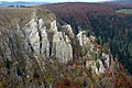
The rock path is around 3 km long. The northern end is at the Col de la Schlucht at an altitude of 1139 meters, the southern end is at the Krappenfels at an altitude of 980 meters. A signpost at Col gives the hiking time to Krappenfels 1 hour 35 minutes. Since the path passes steep rocky passages, it is partly secured with wire ropes, iron railings, ladders and footbridges. At one point the path is cut directly through a rock. The path offers spectacular views of the Münstertal, the Col de la Schlucht, the Hohneck and, on clear days, as far as the Swiss Alps . Surefootedness and a head for heights are required when entering. The army also uses the route for marches during soldier training.

Footbridge on the Sentier des Roches

Staircase on the Sentier des Roches

Sentier des Roches, leading through a rock

View into the Vallée de Munster


Access and history
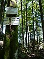
You drive through the Münstertal up to the Col de la Schlucht pass (1139 m). There are numerous parking spaces available there. First you go back a few steps on the road that leads up from Munster. Across the street from the “Relais des Roches” hotel, a staircase leads down into the forest. The path is marked with the blue rectangle (GR 531).
After about half of the route, the rocks at the Col de la Schlucht and some mighty scree fields appear in places . At the Krappenfelsen (965 m) the path turns to the southwest. From there you can see the bald ridge of the Hohneck, the third highest mountain in the Vosges (1363 m). A sign then marks the end of the Sentier des Roches. If you continue on the path, you come to a wide basin , which is used as a high pasture in summer and ends with the Martinswand . It is a popular destination among climbers. There is also a small raised bog ( nature reserve ) below the Martinswand . In the open space, the Ferme Auberge (managed mountain pasture) "Frankenthal" offers the opportunity to stop for a break.
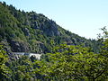
Eastern access road to the Col de la Schlucht (at the same time the former Tramway de Munster à la Schlucht )

Scree field on the Sentier des Roches
southern end of the Sentier des Roches

Basin with Martinswand
Martinswand

High moor below the Martinswand (NSG)


.JPG)

tourism
The Col de la Schlucht and the Hohneck are the starting point for numerous alpine hikes, for example. B. to the ski resort Le Gaschney , down to the glacial lake Lac de Schiessrothried , to the Dagobert grotto (Hexenloch), to the Col du Falimont or to the Ferme Auberge "Les Trois Fours".
The most popular circular hike, which includes the Sentier des Roches, leads from the Col de la Schlucht over the Sentier des Roches, the Ferme Auberge de Frankenthal over the GR 531 to Le Gaschney / Ferme Auberge Gaschney and then on the GR 5 to the Ferme Auberge Schiessroth , Col du Schaeferthal (1228 m) and finally to Hohneck (1363 m). From there the path leads back to the pass over the Col du Falimont (1306 m) above the Route des Crêtes (D 430). Alternatively, you can climb directly from the Ferme Auberge de Frankenthal to the Col du Schaeferthal and, if you like, make a detour from there over the Lac de Schiessrothried, from where it goes very steeply over the Wormspel to Hohneck.
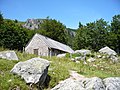
Ferme Auberge de Frankenthal

View of the Hohneck from the east

Lac de Schiessrothried with Hohneck in the background


Sometimes a circular hike over the Sentier des Roches is also combined with another loop to the deer stones in the north of the Col de la Schlucht, a path that also has some climbing spots.

Geology and botany
The bedrock of the mountain range is granite . In the spring of Roches bloom along the Sentier in rivulets marsh marigolds and June Alpine anemones .
swell
- Mariotte, Ruth: Hiking: Alsace and Vosges. Cologne: DuMont Reiseverlag, 3rd edition, 2004.
- Scherfling, Karlheinz: "Alpine paths, steep walls, wide ridges. A classic from the Vosges: Via the rock path from Col de la Schlucht to Hohneck". In: Der Schwarzwald 4/2007, 18–19.
credentials
- ↑ http://sitemap.dna.fr/articles/201008/06/henri-strohmeyer-le-pere-des-roches,munster,000002279.php
Coordinates: 48 ° 3 ′ 11.5 " N , 7 ° 1 ′ 22.8" E