Swiss Alps
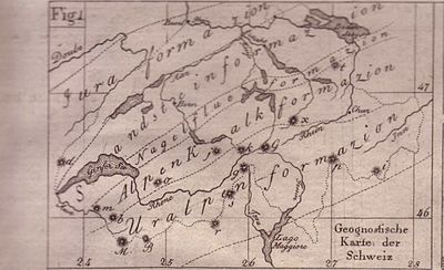
The Swiss Alps ( French Alpes suisses , Italian Alpi svizzere , Rhaeto-Romanic ) are part of the European mountain range called the Alps and the high mountains of Switzerland . The Swiss Alps extend from the Little St. Bernhard , including the Montblanc , Dents du Midi and Chablais groups in the west to the Reschen Pass in the east. This fixation goes back to a suggestion by Christoph Bernoulli in 1811 . The Rhaetian Alps are since then from a Swiss perspective to the old free Rätien limited and now rank among the Swiss Alps.
Classification
In Switzerland, it is common to divide the Alps into three along the Alpine arc, so that Switzerland lies entirely in the Central Alps (also obsolete the Middle Alps ) - the division into Eastern and Western Alps is not of great importance in Switzerland. Geographically, this division does not reflect the Swiss reception of the Alps. In addition, the Splügen Pass , higher than the San Bernardino Pass , is not perceived as separating the mountains and geologically - a slate zone between the Tambo and Suretta nappes within the Penninic - only plays a subordinate role. The geological east-west border runs along the contact zone between the Penninic and Eastern Alps. It follows the flexure Chur-Lenzerheide-Tiefencastel-Septimer-Maloja-Val Fex.
The use of canton names in the subdivisions has been criticized again and again (because the political boundaries naturally run primarily on the ridges, which is not very much in line with today's usage of the subdivision in the valley lines). However, alternative names could not establish themselves.
Traditional division

In the spirit of the Enlightenment, the first classification according to scientific criteria was made according to the age of the geological formations (prevailing doctrine at the time) into
- Uralpen formation
- Alpine limestone formation
- Nagelflue formation
- Sandstone formation
- Jurassic formation
This classification was gradually transferred to the geological classification based on the state of geology.
Orographic classification
Since Claudius Ptolemy , the Swiss Central Alps, the headwaters of the Rhine , Reuss , Aare , Rhone , ( Toce ) and Ticino have played a major role in the geographical perception of the Alps. The two main Alpine ridges running in east-west direction meet here for a short stretch . Ptolemy referred to this area, which at that time was still the highest alpine mountain range, from which all water runs off, the Adula Alps (Latin: ad aqua "water", or Rhaeto-Roman: ad aual "brook"). The four main orographic groups are grouped around this autochthonous massif , separated by the flowing rivers:
|
|
- In order to be able to distinguish these main groups from the actual groups, "in the broader sense" is added to each.
- The Dammagruppe and Aagruppe form the Urner Alps .
- In the Romance-speaking area, the Monte Lone group and the Maggia group are combined to form the Lepontine Alps .
- Savoy Alps (A. Wäber): Mont Blanc, Dents du Midi and Chablais groups
Biogeographical breakdown
Biogeographically, the Alps in the state are also divided into the northern flank of the Alps , the western and eastern central Alps and the southern flank of the Alps .
Geological breakdown
- Subalpine molasses
- Northern Alps
- Aarmassiv
- Gotthard massif
- Mont Blanc and Aiguilles Rouges massif
- Penninikum incl. Bergeller massif
- Eastern Alps
- Southern Alpine (south of the Insubric Line )
Classification of the alpine clubs
The table in the comparison of the divisions of the Swiss Alps provides a comparison of the categorizations according to Swiss Alpine Club , SOIUSA and AVE .

The division of the Swiss Alps according to SAC
The Swiss Alpine Club (SAC) provides for a classification in which an alpine guide / club guide is issued for each group : The structure of the SAC is very much based on political-regional criteria, i.e. cantonal boundaries . This implies that the structure does not run primarily along the valleys, as in other orographic systems, but rather along the ridges, which usually represent typical political and also cultural borders. In this sense, the SAC structure follows the traditional custom of naming mountain groups after the most important valley leading into them, since the Swiss Alpine cantons mostly represent more or less connected valley areas. In the SAC structure, the mountain areas of the large valleys remain connected to the left and right, which is convenient for mountain tourists, and numerous important peaks belong to two groups as the border between two valley areas. The sub-groups themselves are only partially given names, for the others there is a brief list of prominent locations.
- A: Swiss pre-Alps
- A.1: Western Swiss Prealps
- A.1.a: Préalpes de la chaine franco-suisse
- A.1.b: Alps and pre-Alps of Vaud or Alpes et Préalpes vaudoises
- A.1.c: Freiburg Pre-Alps
- A.2: Central Swiss Pre-Alps ( Brünig Pass - Lake Thun )
- A.2.a: Lucerne Prealps
- A.2.b: Unterwaldner Voralpen :
- A.2.c: Schwyz Prealps
- A.3 .: Eastern Swiss foothills ( Appenzellerland , Säntis - Churfirsten )
- A.4 .: Bernese Pre-Alps ( Gstaad - Meiringen )
- A.1: Western Swiss Prealps
- B: Bernese Alps
- B.1: West Bernese Alps ( Sanetsch - Gemmipass , with Wildhorn , Wildstrubel )
- B.2: Central West Bernese Alps (Gemmi - Petersgrat , with Balmhorn , Blüemlisalp , Hockenhorn )
- B.3: Central East Bern Alps ( Tschingelhorn - Finsteraarhorn , with Jungfrau , Fiescherhorn , Grünhorn , Wannenhörner )
- B.4: Central South Bernese Alps ( Bietschhorn , Lötschental , Lötschentaler Breithorn , Nesthorn , Aletschhorn group)
- B.5: East Bernese Alps ( Grindelwald - Grimsel )
- C: Valais Alps
- C.1: Trento - Great St. Bernhard
- C.2: St. Bernhard - Col Collon
- C.3: Col Collon - Theodulpass
- C.4: Thedul Pass - Monte Moro
- C.5: Strahlhorn - Simplon Pass
- C.6: Simplon - Nufenenpass (Gonerli)
- D: Central Swiss Alps
- D.1 .: Urner Alps
- D.1.a (UR 3): Westurner Alps ( Sustenpass - Urirotstock , with Titlis )
- D.1.b (UR 1 / O): Osturner Alps
- D.1.c (UR 2): Göscheneralp - Furkapass - Grimsel (from Sustenpass, Dammastock massif)
- D.2 .: Glarus Alps
- D.3 .: Gotthard massif (Furka - Lukmanierpass )
- D.1 .: Urner Alps
- E: Bündner Alps
- E.1: Tamina Alps and Plessur Alps
- E.2: Bündneroberland and Rheinwald area ( Lukmanierpass - Domleschg )
- E.3: Avers - Misox - Calanca ( San Bernardino Pass to Septimer )
- E.4: Southern Bergell Mountains with Monte Disgrazia
- E.5: Bernina group
- E.6: Albula Alps (Septimer - Flüela )
- E.7: Rätikon
- E.8: Silvretta group and Samnaun
- E.9: Münstertal Alps and Umbrail Group
- E.10: Middle Engadine and Puschlav ( Spöl - Bernina Pass / Puschlav, with Quattervals , Piz Languard , Paradisin , Saosseo , Scalino , Combolo )
- F. Ticino Alps
- F.1: Gridone - Gotthard Pass
- Q.2 : Cristallina - Sassariente
- F.3: Piora - Pizzo di Claro
- F.4: Misox Alps ( Zappothorn - Passo San Jorio )
- F.5: Ticino Prealps (Passo S. Jorio - Generoso )
Central Alps after the Partizione delle Alpi 1926
The division of the Italian-French Partizione delle Alpi from 1926 divides the Central Alps from Col Ferret to the Brenner Pass - of which fall in the Swiss Alps:
|
|
Western Alps to SOIUSA

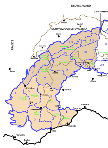
The SOIUSA categorization tries to overcome the division into cantons by grouping together orographically connected mountains. The canton-specific names are largely retained as subgroups.
- Graian Alps (No. 7): only a small part of the southwestern canton of Valais is in Switzerland
- Savoy Prealps (No. 8): only a small part in the southwestern canton of Valais and southeastern Vaud
- Valais Alps (No. 9)
- Lepontine Alps (No. 10). They include the Monte Leone-Sankt Gotthard Alps , the Ticino Alps and the Adula Alps
- Bernese Alps in the broader sense (No. 12). These consist of the Bernese Alps in the narrower sense, the Urner Alps and the Vaud Alps
- Glarus Alps in the broader sense (No. 13). These consist of the Urner-Glarus Alps and the Glarus Alps in the narrower sense
- Swiss Prealps (No. 14). They consist of the Bernese Pre-Alps , the Vaud and Friborg Pre-Alps , the Lucerne and Unterwaldner Pre-Alps , the Schwyz and Uri Pre-Alps and the Appenzell and St. Gallen Pre-Alps
- Lugano Prealps (No. 11). They consist of the Comer Prealps , partly in Switzerland and the Vareser Voralpen , also partly in Switzerland.
Eastern Alps to AVE

The eastern part of the Swiss Alps is assigned to different groups of the Eastern Alps according to the Alpine Club division of the Eastern Alps (AVE) :
- Western Eastern Alps
- Albula Alps
- Bernina group (Bernina and southern Bergell)
- Livigno Alps
- Platta group
- Plessur Alps (Arosa Mountains)
- Central Eastern Alps
- Southern Eastern Alps
Swiss Alps in times of climate change
The Swiss Alps are now massively affected by the effects of climate change . In 2019, only 1,463 Swiss glaciers were counted, which corresponds to a loss of 700 glaciers since the 1970s due to melting. Climate scientists are currently assuming that the majority of Alpine glaciers will have disappeared in the 21st century. Instead, numerous new lakes will be created. Also can be explained by the geomorphology demonstrate that the potential risk for humans and animals in the Alpine valleys has risen sharply since mountainsides by the massive ice melting of permafrost are increasingly losing stability, resulting in landslides and rockslides. The Swiss photographer Daniel Schwartz , who caused a sensation in 2017 with a series about the extent of the destruction of the glaciers by climate change, described it as follows: “It's no longer a mountain. That's an animal. One that has been peeled of fur and skin. His skeleton is now stuck in the rock. "
See also
- Swiss Alpine Club
- List of mountains in Switzerland
- List of valleys in Switzerland
- List of Swiss glaciers
- List of passports in Switzerland
literature
- Heinz Staffelbach: Handbook of the Swiss Alps. Plants, animals, rocks and weather. The nature guide . Haupt Verlag, Bern 2008, ISBN 978-3-258-07638-6 .
- Toni P. Labhart: Geology of Switzerland . Ott-Verlag, 7th edition, Bern 2005, ISBN 3-7225-0007-9 .
- Oskar Bär: Geography of Switzerland . Teaching material publisher of the Canton of Zurich, 1973.
- Eduard Imhof : Swiss World Atlas .
- Sergio Marazzi: Atlante Orografico delle Alpi. SOIUSA . Pavone Canavese (TO), Priuli & Verlucca editori, 2005. ISBN 978-88-8068-273-8 (Italian).
- Sergio Marazzi: La "Suddivisione orografica internazionale unificata del Sistema Alpino" (SOIUSA) - the complete article with detailed illustrations (pdf, Italian; 1.6 MB).
- Jürg Früh : Geography of Switzerland. Volume I, Fehr'sche Buchhandlung, St. Gallen 1930.
- Charles Knapp, Maurice Borel, Victor Attinger, Heinrich Brunner, Société neuchâteloise de géographie (editors): Geographical Lexicon of Switzerland . Volume 1: Aa - Emmengruppe . Verlag Gebrüder Attinger, Neuchâtel 1902, pp. 38-64, keyword Alps ( scan of the lexicon page ).
Web links
- Jean-François Bergier : Alps. In: Historical Lexicon of Switzerland .
- Swiss Alps in the Federal Administration
Individual evidence
- ↑ Similar systematics are still common in the French Alps, such as the Montagne de l'Ubaye around the Ubaye Valley. Naming mountain groups after the central valleys is one of the most original concepts of mountain structuring, which has led to the fact that many established mountain groups in the other Alpine regions still have different names from the other side, as is customary in the area.
- ↑ Christoph Bernoulli : Geognostic overview of Switzerland, together with a systematic index of all mineral bodies occurring in this country and their locations. Basel 1811
- ↑ Nature and Landscape Switzerland ( Memento of March 21, 2007 in the Internet Archive ) Retrieved on September 26, 2015.
- ↑ Club leader of the SAC , overview
- ↑ Préalpes de la chaine franco-suisse. Guide Club Alpin Suisse
- ↑ Guide des Alpes et Préalpes vaudoises. Guide Club Alpin Suisse
- ↑ Willy on the Maur: Central Switzerland Prealps. Schwyz Prealps. Unterwaldner Voralpen. Pilatus-Schrattenflue chain. Alpine guide / club guide, ISBN 3-85902-146-X
- ^ Oskar Allgaeuer: The pre-Alps between Bruenigpass and Thunersee. Lucerne Prealps. Bucher, Lucerne 1932, Edition Swiss Alpine Club
- ^ Oskar Allgaeuer: The pre-Alps between Bruenigpass and Thunersee. Unterwaldner Voralpen. Bucher, Lucerne 1930, Edition Swiss Alpine Club
- ↑ Säntis - Churfirsten. From Appenzell to the Walensee
- ↑ Martin Gerber: Berner Voralpen. From Gstaad to Meiringen. ISBN 3-85902-165-6
- ↑ SAC Club Guide Bernese Alps , overview
- ↑ Jürg Müller: Gemmi to Petersgrat Alpine guide / club guide. Bernese Alps 2nd 8th edition, SAC, 1993, ISBN 978-3-85902-132-7
- ^ Karl Hausmann: Tschingelhorn to Finsteraarhorn. Alpine guide / club guide. Bernese Alps 2nd 9th edition, Bergverlag Rother , 1997, ISBN 978-3-85902-162-4
- ↑ Ueli Mosimann: Grindelwald to the Grimsel. Alpine guide / club guide. Bernese Alps 5th 6th edition, Bergverlag Rother, 1996, ISBN 978-3-85902-155-6
- ↑ Maurice Brandt: From Trient to Gr. St. Bernhard. Club guide Valais Alps 1st SAC, 1999.
- ↑ SAC Club Guide Uri Alps Overview
- ^ Bernard Condrau: Tamina and Plessur Mountains. 1988, ISBN 978-3-85902-092-4
- ↑ Manfred Hunziker: Bündner Oberland and the Rhine forest area. 1996, ISBN 978-3-85902-154-9
- ^ Manfred Hunziker: Obverse - Misox - Calanca. 1994, ISBN 978-3-85902-140-2
- ↑ Bündner Alpen 3 map
- ^ Ruedi Meier: Southern Bergellerberge and Monte Disgrazia. 1990, 2006, ISBN 978-3-85902-252-2
- ^ Pierino Giuliani: Bernina Group. 1993, 2007, ISBN 978-3-85902-212-6
- ^ Manfred Hunziker: Albula (Septimer - Flüela). 1986, 2000, ISBN 978-3-85902-187-7
- ↑ Paul My Heart: Rätikon. 1989, ISBN 978-3-85902-099-3
- ^ Bernard Condrau: Silvretta and Samnaun. 1985, ISBN 978-3-85902-048-1
- ↑ Martin Perret: Engiadina Bassa / Val Müstair. Münstertal Alps and Umbrail Group. 1986, ISBN 978-3-85902-058-0
- ^ Bernard Condrau, Walter Candinas: Mittleres Engadin and Puschlav. Spöl to Bernina Pass and Puschlav on both sides 1984, ISBN 978-3-85902-068-9
- ↑ SAC Club Guide Ticino Alps. Overview
- ↑ a b c d https://www.nzz.ch/schweiz/klimawandel-in-den-alpen-wird-das-bergwandern-ditzt-riskanter-ld.1423265
- ↑ The glacier initiative wants to anchor the CO2 reduction in the constitution - the climate strikers are doing this too slowly. Neue Zürcher Zeitung, January 31, 2019, accessed on January 31, 2019 (Swiss Standard German).
- ↑ https://www.taz.de/Archiv- sucht/!5560240 /
Coordinates: 45 ° 56 ' N , 7 ° 52' E ; CH1903: six hundred and thirty-three thousand two hundred and twenty / 87352


