
Churfirsten
| Churfirsten | ||
|---|---|---|
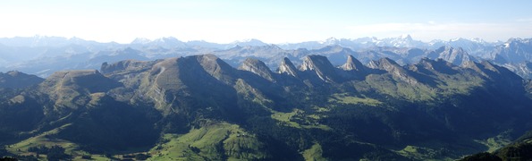
 Hinterrugg, Schibenstoll, Zuestoll, Brisi, Frümsel and Selun (from left to right) recorded below the Rotstein Pass |
||
| height | 2306 m above sea level M. | |
| location |
|
|
| Mountains | Appenzell Alps | |
| Dominance | 5.4 km → Gamsberg | |
| Notch height | 470 m ↓ Gulms | |
| Coordinates | 741008 / 224001 | |
|
||
 Churfirsten seen from the south over the Walensee |
||

The Churfirsten are - depending on how they are counted - six to thirteen mountains in the canton of St. Gallen in Switzerland , which together form a mountain range with a ridge that is interrupted several times . They belong to the Appenzell Alps and lie between the upper Toggenburg and the Walensee . In earlier centuries they were on the border with the dominion of Chur.
There is a small rock formation called «Churfirsten» at the Sipplinger Dreieck north of the Überlinger See.
description
The Churfirsten are a chain of relatively young limestone elevations . In the north they run out in relatively flat ridges to the Toggenburg. To the south, the chain falls almost vertically to Walenstadtberg and then to Lake Walen up to 419 m above sea level. M. from. The rocky southern flank was significantly shaped by the Rhine Glacier in the Würme Ice Age . The Churfirsten are the symbol of Toggenburg and distinctive points of the Sarganserland .
The rock cover of the summit structure of the Churfirsten stretches like a snake from the west (head of the snake) up over the entire back and has a strikingly curved tail end on the sickle ridge . The Sichelchamm is already southeast of the end of the Churfirsten chain on the 'Nideri' and continues in another mountain range with surprisingly constant summit heights.
The peaks

The "seven Churfirsten" as they u. a. mentioned in tourism advertising are from west to east: Selun ( 2205 m ), Frümsel ( 2263 m ), Brisi ( 2279 m ), Zuestoll ( 2235 m ), Schibenstoll ( 2234 m ), Hinterrugg ( 2306 m ) and Chäserrugg ( 2262 m ). The Wildenmannlisloch can be found on the Selun .
The non-“official” peaks further west are: Wart ( 2068 m ), Schäären ( 2171 m ), Nägeliberg ( 2163 m ), Leistchamm ( 2101 m ). The lowest number of six Churfirsten arises from the fact that the Chäserrugg is actually not even considered a secondary peak, because it is not separated from the Hinterrugg by a saddle at least 30 meters high ; it's only 14 meters. Gamserrugg , east of Chäserrugg, does not belong to the Churfirsten either.
The Chäserrugg with its summit restaurant is accessed by the funicular from Unterwasser to the Iltios and from there by the Iltios – Chäserrugg aerial cableway . "Chäserrugg" is also the name for the mountain ridge that slopes north to Stöfeli with a ski slope and ski lift in winter. The slope leads over the Stöfeli to the Iltios and is part of the Obertoggenburg ski area . Since 2016, a new gondola lift has been running from Espel ( 1262 m ) to the Stöfeli middle station ( 1682 m ) and on to the middle of the Chäserrugg ( 2070 m ). The old Stöfeli ski lift was dismantled. Signs tell skiers not to leave the slopes, as the area around the Chäserrugg is rocky and criss-crossed by karst holes .
Surname
In the past the name was often wrongly derived from the "seven electors " of the Holy Roman-German Empire . With its "collegial formation", the mountain range was reminiscent of the motif of the German electoral college, which has been popular since the Middle Ages , which is why the seven peaks were defined as the actual Churfirsten.
The name was given by the monastery of St. Gallen , which gave expression to its position as an imperial abbey . From the conflicts with the Toggenburgers , the mockery "Kuhfürsten" or "Kuhfirsten" arose. The first card by JJ Bühler from 1784 contains the designation "The VII Electors". This form of name still prevails in the 19th century and the Chäserrugg is usually recorded as "Kaiserruck". It was not until the Eschmann card from 1854 that the choice was made for “Churfirsten”.
photos

The Churfirsten are from Rautispitz there like a snake in the background Alpstein massif

Churfirsten and Obertoggenburg from the Schäferhütte on the Wildhauser Schafberg in Alpstein
Churfirsten from the Säntis

On the Selun

The summit cross of the Frümsel

On the Brisi

On the Zuestoll

On the Schibenstoll

Six Churfirsten in the sunset


Individual evidence
- ↑ wanderland.ch → Walensee ( Memento of the original from July 14, 2014 in the Internet Archive ) Info: The archive link was inserted automatically and has not yet been checked. Please check the original and archive link according to the instructions and then remove this notice.
- ↑ The difference in the Worm Ice Age Rheingletscher near Sargans (Canton St. Gallen) and the late glacial glacier levels in the Walensee valley and in the Rhine Valley ( Memento of the original from July 14, 2014 in the Internet Archive ) Info: The archive link was automatically inserted and not yet checked . Please check the original and archive link according to the instructions and then remove this notice.
- ↑ Schweizerisches Idiotikon, sv “Churfirst” ( Memento of the original from February 26, 2014 in the Internet Archive ) Info: The archive link was inserted automatically and has not yet been checked. Please check the original and archive link according to the instructions and then remove this notice.
literature
- Emil Zopfi (Ed.): Churfirsten - Over the Seven Mountains ( Mountain Monograph 14) Zurich 2006, ISBN 978-3-909111-22-0 .
- Clausdieter Schott : The VII Electors. Legal history and topography , in: Effects of European legal culture. Festschrift for Karl Kroeschell , Munich 1997, ISBN 3-406-42994-7 , pp. 1065-1092.
Web links
- All 7 Churfirsten in one day
- Tour reports and photos: Selun , Frümsel , Brisi , Zuestoll , Schibenstoll , Hinterrugg and Chäserrugg . So Nägeliberg and Schäären