
Sickle lamb
| Sickle lamb | ||
|---|---|---|
 Sickle-shaped folds on the sickle ridge |
||
| height | 2269 m above sea level M. | |
| location | Canton of St. Gallen | |
| Mountains | Churfirsten-Werdenberg | |
| Dominance | 0.75 km → Gamsberg | |
| Notch height | 170 m ↓ Scharte south of Scheffloch | |
| Coordinates | 745 916 / 222090 | |
|
||
| Type | Minor peaks | |
| rock | limestone | |

The Sichelchamm is a peak in the Swiss canton of St. Gallen above the eastern end of the Walensee . The municipal areas of Grabs in the Rhine Valley and Walenstadt in the Seeztal valley to the west meet at the summit , with the Gamsberg covering it from the Rhine valley side .
Characteristic
A clearly visible rock band, which stretches over the Churfirsten over the Walensee, forms a prominent fold in the western flank of the Sichelchamm; The mountain owes its name to these sickle-shaped parallel arches. The field name in this area is called “In den Gassen”. In the central zone of the fold there are other structures like a small free-standing vertical wall. Seen up close, the flank loses its defining element.
The chain runs further over the Gamsberg and Fulfirst to Alvier and Gauschla whose Vorgipfel Gonzen the conclusion of the Valley division of Sargans forms: the Rhine turns to the northeast and leaves the western also from, Rhine glacier created the Valley of Seez.
The chain with the Churfirsten continues from the Sichelchamm towards the west, the peaks remain high for the entire 15 km length between 2200 and 2380 meters, and then at the western end of the Selun they descend in a serpentine manner, see Churfirsten .

Sichelchamm, left, prominently above the eastern end of the Walensee
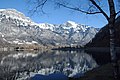
Winter picture with sickle lamb

