
Sargans
| Sargans | |
|---|---|
 |
|
| State : |
|
| Canton : |
|
| Constituency : | Sarganserland |
| BFS no. : | 3296 |
| Postal code : | 7320 |
| UN / LOCODE : | CH SAR |
| Coordinates : | 752 110 / 212 699 |
| Height : | 483 m above sea level M. |
| Height range : | 474–1822 m above sea level M. |
| Area : | 9.46 km² |
| Residents: | 6133 (December 31, 2018) |
| Population density : | 648 inhabitants per km² |
| Website: | www.sargans.ch |
 Sargans from the west |
|
| Location of the municipality | |
  |
|
Sargans [ˌsarˈgans] (stress on the second syllable; also in the local dialect, whereas in the south-eastern Swiss dialect of the surrounding area the older sounding Sargaas [ˌsarˈgaːs] , which reflects Dust's law , lives on) is a political municipality or a historical town in the Swiss canton of St. Gallen and the center of the Sarganserland .
geography
Sargans lies at the intersection of the Alpine Rhine Valley, which bends from southeast to northeast, and the Seeztal , which connects the Alpine Rhine Valley with Lake Zurich without any significant difference in altitude.
The lowest point is the train station at an altitude of 480 m above sea level. M. , the highest point of the municipality is on the Gonzen at an altitude of 1830 m above sea level. M. The northeastern district of Vild belongs to the municipality .
Due to its geographical location, Sargans is today a traffic junction, regional economic and cultural center and educational location with numerous schools.
Neighboring communities are Mels and Vilters-Wangs , with these together Sargans forms an agglomeration of around 20,000 inhabitants.
Place name
The name is mentioned in the year 765 as de Senegaune, later than in Senegaunis, in Sannegannis and similar, in 1284 as Sangans and from the 15th century in the current spelling. The interpretation of the name is uncertain. Possibly it is based on the Celtic-Roman personal name "Sanucus" expanded with the suffix -ānus, plural -ānes , which would mean "place where the clan of Sanucus lives". Such a personal name is documented in the Colonia Augusta Raurica , and a phonetic development from * Sanucānes to the historical forms of the Sanegans type is linguistically possible.
The place name is explained in folk etymology in a legend that says that the inhabitants of the settlement, which was then still nameless, sent a child to the river Saar on the plains with the wish to name their place after the animal that would then swim. It was a goose ...
history

The history and present of Sargans has always been determined by traffic. As a “double gate to the Alps” with entrances from the Seez and Rhine valleys, traces of prehistoric, Roman, medieval and modern settlements are combined in a small area. The railway, built in 1858/59, as well as modern roads and highways underline the good traffic situation, the open attitude and a diverse network of relationships between the Sargans in the near and far.
From the 1st to the 3rd century there was a Roman manor in Sargans. Ore was already being mined on the Gonzen at that time. The Gonzen iron mine was in operation until 1966 and can be visited today. For both Sargans and the Sarganserland, it has been an important economic factor for centuries.
In the year 765 AD Sargans was mentioned for the first time as "Senegaune". There is evidence of a Christian church in the 9th century, the first tower of the castle was built from 1100. Until 1798 the castle was the center of the County of Sargans and eponymous for the noble family of the Counts of Werdenberg-Sargans . They found the town or city of Sargans around 1260. The townspeople had privileges over the neighboring towns of the County of Sargans until 1798. In 1405 Sargans was besieged by them during the Appenzell Wars. At the beginning of February 1445 there was the siege of Sargans , during which it was attacked as part of the Old Zurich War and - with the exception of the castle - was destroyed to the ground. The town was destroyed again by a major fire in 1811 . Since summer 2007 the “Sarganser Kulturpfad” has been drawing attention to sights. In addition to the houses in the center, surrounded by moats and walls, the hamlets of Schwefelbad, Farb, Töbeli, Vild , Ratell and Prod also belong to the municipality of Sargans.
Sargans has been the capital of the Sarganserland in the newly founded canton of St. Gallen since 1803 . After the regulation of the Rhine and the amelioration of the Rhine plain, a strong population growth and an expansion of the settlement area began in the 20th century.
coat of arms

Today's municipal coat of arms shows a goose, interpreting the name according to folk etymology as "Sar-Gans" (" talking coat of arms ").
The former county of Sargans, on the other hand, had a blue shield with three gold stars as its coat of arms.
politics
The legislature of the municipality of Sargans is formed by the citizens' assembly , at which all Swiss nationals of age are entitled to vote. It usually meets once a year.
The executive is formed by the five-member municipal council. This currently consists of Jörg Tanner (glp, mayor ), Hans Bärtsch (CVP), Bernhard Hauser (SP), Christian Lamm and Roland Wermelinger (both independent).
Attractions

The most important Sarganser sight and landmark and symbol of the whole Sarganserland is the Sargans Castle , which since 1966 houses the «Museum Sarganserland». The museum was honored with the "Museum of the Year in Europe" award in 1984 and in 1987 was included in the list of the 37 most popular museums in the world. Another attraction is the Gonzen iron mine, which is now accessible as a show mine and makes an eventful tour “underground” possible.
The sights of Sargans are accessible on the informative Sargans culture trail.
Churches
The main Roman Catholic church is in an elevated position on the edge of the old town of St. Oswald & Cassian .
The Reformed Church of Sargans was built in 1959 in the north-west of the town .
At Vild , at the beginning of the mule path above Matug, there is the Vild Lady Chapel .
Culture
Sargans, a historical town since the middle of the 13th century, forms the backdrop for the Sargans Medieval Days, which have been held since 2009 . Under the aspect of “small but nice”, attempts are made to portray a market day around 1250 as authentically as possible. The implementation is in the hands of local initiators (current management: Mathias Bugg), with the participation of specialized groups from the Middle Ages. Organization: Municipality of Sargans with the Sarganser Kulturpfad and Sarganserland Historical Association. The Historia Sanegauns association, founded on March 27, 2015, is currently responsible for the organization.
education

Sargans has a canton school , founded in 1963 as the first rural secondary school in the canton of St. Gallen, which, in addition to the grammar school, also offers business and technical secondary schools. The canton school currently teaches around 750 students and has around 100 teachers. In addition to school operations, it develops a rich cultural life, especially with the adult education in Sarganserland, which has been established since 1976 (Rectors: 1963–1991 André Schwizer, 1991–2001 Sepp Dietrich, 2001–2020 Stephan Wurster).
Not far from the canton school is the regional sports facility (RSA), which is open for school sports, but also especially for club sports and events, and represents a regional meeting point. The sports hall was demolished in 2010, rebuilt and inaugurated in June 2012 as the “Sporthalle Riet”. Since November 2006, the “Eispark Sarganserland”, the first ice rink in the Sarganserland, has also been operated on the site during the winter months.
traffic
Sargans is a traffic junction, as the Rhine Valley, the Seeztal and the Chur Rhine Valley converge here. In road traffic there is a motorway triangle with the A3 and A13 . In rail transport strikes in Sargans the railway bridge brick-Sargans on the railway line from Chur to Rorschach .
The old Schollbergstrasse from Sargans to Trübbach , completed in 1492, is the first federal driveway. It has been restored and has been accessible as a hiking trail since 2014.
- gallery

City Church of Sargans
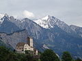
Sargans Castle with Vilan in the background, Regitzerspitze in the middle distance (above the tower), the highest point of the Fläscherberg
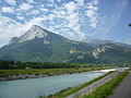
Gonzen with the Rhine (view from Fläsch under the Ellhorn, on the northwestern Fläscherberg)
Coat of arms of the Counts of Werdenberg-Sargans


Personalities
- Josef Anton Henne (1798–1870), historian and songwriter
- Johann Baptist Laule (1817–1895), painter
- Heinrich Seitter (1902–1991), botanist and honorary citizen of Sargans
literature
- Lucie Bolliger Ruiz: The place and field names of Sargans. 1984.
- Lucie Bolliger Ruiz: The Romanic place and field names of Sargans. In: Vox Romanica 49/50 (1990/91), pp. 165-270.
- Mathias Bugg: Sargans . In: Swiss city images. Urban iconographies (15th – 20th centuries). Edited by Bernd Roeck u. a. Zurich 2013, pp. 497–504 (Development of the city of Sargans based on image sources).
- Mathias Bugg: Sargans (city). In: Historisches Lexikon des Fürstentums Liechtenstein, Vol. 2, 2013, pp. 809–810.
- Mathias Bugg: Out and about on the Sarganser Kulturpfad. 2008.
- Mathias Bugg: Sargans Castle around 1900. 1999.
- Div. Authors: Art guide through Switzerland. Sargans, Volume 1, 2005.
- Benedikt Frei : The Roman manor of Sargans. 1971.
- Wolfgang Göldi: Sargans. In: Historical Lexicon of Switzerland .
- Johannes Huber: Catholic places of prayer in Sargans. 2002.
- Paul Hugger : The Gonzen. 2000 years of mining. 1991.
- Franz Perret : 1100 years of Sargans parish 850–1950. 1950.
- Erwin Rothenhäusler, Dora Fanny Rittmeyer, Benedikt Frei: The Art Monuments of the Canton of St. Gallen, Volume I: Sargans District. (= Art Monuments of Switzerland. Volume 25). Edited by the Society for Swiss Art History GSK. Bern 1951. DNB 750089172 .
- Anton Stucky: Sargan's school history. 1982.
- Werner Vogler (Ed.): Sargans in old views. 1991.
- Collection of Swiss Legal Sources , XIV. Department: The Legal Sources of the Canton of St. Gallen, Part Three: The Landscapes and Country Cities, Volume 2: The Legal Sources of the Sarganserland by Sibylle Malamud and Pascale Sutter, Basel 2013 (online) .
Web links

- Official website of the municipality of Sargans
- Website about Sargans Castle and Sarganserland Museum (accessed on January 21, 2011)
- Historical pictures of Mels and Sargans
- Wolfgang Göldi: Sargans. In: Historical Lexicon of Switzerland .
Individual evidence
- ↑ Permanent and non-permanent resident population by year, canton, district, municipality, population type and gender (permanent resident population). In: bfs. admin.ch . Federal Statistical Office (FSO), August 31, 2019, accessed on December 22, 2019 .
- ↑ a b Lexicon of Swiss municipality names . Edited by the Center de Dialectologie at the University of Neuchâtel under the direction of Andres Kristol. Frauenfeld / Lausanne 2005, p. 796 f.
- ^ Linguistic Atlas of German-speaking Switzerland, original material .
- ↑ Lucie Bolliger Ruiz: The Romanic place and field names of Sargans. In: Vox Romanica 49/50 (1990/91), p. 245.
- ^ Museum Sarganserland . Retrieved October 19, 2013.
- ^ Sarganser Kulturpfad . Retrieved October 19, 2013.
- ↑ Sargan's Middle Ages Day . In: medievalandmore . May 29, 2011. Retrieved October 14, 2011.
- ↑ Medieval Day in Sargans . comthurey-alpinum.ch. Retrieved October 13, 2011.
- ↑ May 21, 2011 - Medieval Day in Sargans . lively-geschichte.ch. September 23, 2010. Retrieved October 13, 2011.