
Motorway 13 (Switzerland)
| Autobahn 13 in Switzerland | ||||||||||||||||||||||||||||||||||||||||||||||||||||||||||||||||||||||||||||||||||||||||||||||||||||||||||||||||||||||||||||||||||||||||||||||||||||||||||||||||||||||||||||||||||||||||||||||||||||||||||||||||||||||||||||||||||||||||||||||||||||||||||||||||||||||||||||||||||||||||||||||||||||

|
||||||||||||||||||||||||||||||||||||||||||||||||||||||||||||||||||||||||||||||||||||||||||||||||||||||||||||||||||||||||||||||||||||||||||||||||||||||||||||||||||||||||||||||||||||||||||||||||||||||||||||||||||||||||||||||||||||||||||||||||||||||||||||||||||||||||||||||||||||||||||||||||||||
| |
||||||||||||||||||||||||||||||||||||||||||||||||||||||||||||||||||||||||||||||||||||||||||||||||||||||||||||||||||||||||||||||||||||||||||||||||||||||||||||||||||||||||||||||||||||||||||||||||||||||||||||||||||||||||||||||||||||||||||||||||||||||||||||||||||||||||||||||||||||||||||||||||||||
| map | ||||||||||||||||||||||||||||||||||||||||||||||||||||||||||||||||||||||||||||||||||||||||||||||||||||||||||||||||||||||||||||||||||||||||||||||||||||||||||||||||||||||||||||||||||||||||||||||||||||||||||||||||||||||||||||||||||||||||||||||||||||||||||||||||||||||||||||||||||||||||||||||||||||
 |
||||||||||||||||||||||||||||||||||||||||||||||||||||||||||||||||||||||||||||||||||||||||||||||||||||||||||||||||||||||||||||||||||||||||||||||||||||||||||||||||||||||||||||||||||||||||||||||||||||||||||||||||||||||||||||||||||||||||||||||||||||||||||||||||||||||||||||||||||||||||||||||||||||
| Basic data | ||||||||||||||||||||||||||||||||||||||||||||||||||||||||||||||||||||||||||||||||||||||||||||||||||||||||||||||||||||||||||||||||||||||||||||||||||||||||||||||||||||||||||||||||||||||||||||||||||||||||||||||||||||||||||||||||||||||||||||||||||||||||||||||||||||||||||||||||||||||||||||||||||||
| Operator: | Federal Roads Office | |||||||||||||||||||||||||||||||||||||||||||||||||||||||||||||||||||||||||||||||||||||||||||||||||||||||||||||||||||||||||||||||||||||||||||||||||||||||||||||||||||||||||||||||||||||||||||||||||||||||||||||||||||||||||||||||||||||||||||||||||||||||||||||||||||||||||||||||||||||||||||||||||||
| Start of the street: |
St. Margrethen ( 47 ° 27 ′ N , 9 ° 39 ′ E ) |
|||||||||||||||||||||||||||||||||||||||||||||||||||||||||||||||||||||||||||||||||||||||||||||||||||||||||||||||||||||||||||||||||||||||||||||||||||||||||||||||||||||||||||||||||||||||||||||||||||||||||||||||||||||||||||||||||||||||||||||||||||||||||||||||||||||||||||||||||||||||||||||||||||
| End of the road: |
Ascona ( 46 ° 10 ′ N , 8 ° 47 ′ E ) |
|||||||||||||||||||||||||||||||||||||||||||||||||||||||||||||||||||||||||||||||||||||||||||||||||||||||||||||||||||||||||||||||||||||||||||||||||||||||||||||||||||||||||||||||||||||||||||||||||||||||||||||||||||||||||||||||||||||||||||||||||||||||||||||||||||||||||||||||||||||||||||||||||||
| Overall length: | approx. 195 km | |||||||||||||||||||||||||||||||||||||||||||||||||||||||||||||||||||||||||||||||||||||||||||||||||||||||||||||||||||||||||||||||||||||||||||||||||||||||||||||||||||||||||||||||||||||||||||||||||||||||||||||||||||||||||||||||||||||||||||||||||||||||||||||||||||||||||||||||||||||||||||||||||||
|
Canton : |
||||||||||||||||||||||||||||||||||||||||||||||||||||||||||||||||||||||||||||||||||||||||||||||||||||||||||||||||||||||||||||||||||||||||||||||||||||||||||||||||||||||||||||||||||||||||||||||||||||||||||||||||||||||||||||||||||||||||||||||||||||||||||||||||||||||||||||||||||||||||||||||||||||
 |
||||||||||||||||||||||||||||||||||||||||||||||||||||||||||||||||||||||||||||||||||||||||||||||||||||||||||||||||||||||||||||||||||||||||||||||||||||||||||||||||||||||||||||||||||||||||||||||||||||||||||||||||||||||||||||||||||||||||||||||||||||||||||||||||||||||||||||||||||||||||||||||||||||
| A13 near Bad Ragaz | ||||||||||||||||||||||||||||||||||||||||||||||||||||||||||||||||||||||||||||||||||||||||||||||||||||||||||||||||||||||||||||||||||||||||||||||||||||||||||||||||||||||||||||||||||||||||||||||||||||||||||||||||||||||||||||||||||||||||||||||||||||||||||||||||||||||||||||||||||||||||||||||||||||
|
Course of the road
|
||||||||||||||||||||||||||||||||||||||||||||||||||||||||||||||||||||||||||||||||||||||||||||||||||||||||||||||||||||||||||||||||||||||||||||||||||||||||||||||||||||||||||||||||||||||||||||||||||||||||||||||||||||||||||||||||||||||||||||||||||||||||||||||||||||||||||||||||||||||||||||||||||||
The Swiss Autostrasse 13 or Autobahn 13 is a two-lane, sometimes four-lane national road (N13). After the A2, it forms the country's second most important north-south connection. Although located exclusively on Swiss territory in the cantons of Ticino , Graubünden and St. Gallen , it also plays an important role in the development of the Principality of Liechtenstein . The actual crossing of the Alps takes place on the road between Thusis and Soazza built in 1967.
history
Section St. Margrethen – Bad Ragaz
At the end of August 1962, the 5-kilometer N13 between Sargans and Bad Ragaz was opened to traffic, followed by the 18-kilometer section between St. Margrethen and Oberriet at the end of 1964. At that time, these two sections were two-lane motorways (2nd class national roads). The completion shortly after the federal government's decision to build a national road network on June 21, 1961 is due to the fact that the canton of St. Gallen was planning motorways on its own before the decision was made.
As of 1966, the section between Oberriet and Sargans, which was still missing at the time, was already planned or under construction. It was completed in the 1970s. The section between St. Margrethen and Haag was a car road, while the section between Haag and Sargans was a motorway. Little by little, the remaining sections of the road were converted into motorways. In 2002 the last expansion, the expansion of the Au to Diepoldsau autobahn into a motorway, was completed; it was the last construction site of the N13 as part of the network expansion and the national road network in the canton of St. Gallen. The expansion of non-directional motorways on motorways was felt to be urgent at the time, as the section of the motorway in the Rhine Valley was considered to be a “death stretch”, with 94 traffic fatalities between 1976 and 2002.
Bad Ragaz – Bellinzona section
The alpine crossing has a 2000 year history and was already committed in Roman times and before. It was in competition with the more heavily traveled Splügen Pass , around 15 kilometers to the east. After 1817, after a famine in the canton of Graubünden, the road construction was pushed ahead and from 1818 to 1822 the first continuously renewed road over the San Bernardino Pass was opened. A year-round connection for vehicles on this route only existed since 1967 with the opening of the San Bernardino Tunnel . On April 10, 1965, the tunnel tube of the San Bernardino tunnel between the villages of Hinterrhein and San Bernardino was broken through and opened to traffic on December 1, 1967. The 6.6 km long road tunnel for the first time enabled a year-round road connection for the southern Graubünden valleys Misox and Calancatal to the capital Chur and became part of the national road N13 (today A13). In 1969 the construction of the last section from Bärenburg to Reischen began. The section cost 29 million Swiss francs and was opened in 1973. This created a continuous road from Thusis to Soazza. The access routes to Thusis and Soazza were mastered on the cantonal roads.
On November 7, 2016, another section of the road was replaced; the passage through Roveredo became superfluous with a bypass in a tunnel, which had been under construction since 2008. The tunnel breakthrough was on November 30, 2012.
Bellinzona-Ascona section
The part between Ascona and a roundabout south of Gaggiole in Ticino is developed as a car road. This part was a cantonal road until 2020 before it was added to the national road network.
course

The A13 begins in Gallic santa- St.Margrethen following the A1 , is planned on the Vorarlberg side of another after the Bodensee Expressway S18 . It then leads through the entire Rhine Valley , along the border with Austria and Liechtenstein, to Sargans , where the A3 joins the A13.
The motorway then continues to the Graubünden capital Chur , although the two lanes on a section between Zizers and Chur did not run parallel due to the subsequent expansion of the original road. In 2017 the lane leading north was relocated to the further west. At Reichenau there is the possibility to turn off on the main road 19 in the direction of Flims - Disentis / Mustér - Andermatt - Brig . From the Reichenau junction, the A13 bypasses the Isla Bella floodplain area as a non-directional road in a tunnel, and then as a separate road through Domleschg to reach Thusis (around 600 m above sea level ).
From here the again non-directional car road to cross the Alps rises first through the Viamala Gorge and then crosses the Schams valley and the Roflaschlucht to the uppermost section of the valley, the Rheinwald . The formerly important Splügenpass branches off at Splügen and the road joins the last valley community, Hinterrhein , at around 1650 m above sea level. M. in the 6.6 km long San Bernardino tunnel.
After the tunnel, characterized by avalanche protection galleries and long hairpin bends, it goes over the Nanin and Cascella bridges down to Misox to Mesocco at 730 m above sea level. M. . From Thusis to Mesocco the distance is approx. 58 km with an altitude difference of over 1000 meters.
South of Mesocco, the road below Soazza becomes a motorway again until shortly before Roveredo GR . Until the opening of a bypass tunnel in 2016, the autostrasse cut through the center of Roveredo. The A13 continues out of the valley and joins the A2 shortly before the Ticino capital Bellinzona at an altitude of 240 m above sea level. M. at.
Between Ascona and a roundabout south of Gaggiole in Ticino , the A13 has been developed as a motorway. Locarno is bypassed with the 5 km long Mappo-Morettina tunnel . In this there is one lane for each direction.
Serious accidents
The originally largely non-directional section in the Rhine Valley from Sargans to St. Margrethen was for a long time considered a "deadline": there were repeated serious frontal collisions. In the years from 1979 to 2002 died on the former highway A13 96 people, five times more than usual in the Swiss national highway network. The risk of accidents has been reduced by expanding the entire route into a motorway.
On September 16, 2006, a fire broke out in the Viamala Tunnel after a frontal collision between a coach and a passenger car, in which nine people were killed. A second passenger car was involved in the collision. At least four other vehicles were affected in the tunnel.
After a coach burned out in the San Bernardino tunnel shortly before Pentecost weekend 2018, the tunnel had to be closed for several days.
Shifting heavy transit traffic to rail
As a transit route, the A13 must also be relieved by the ongoing efforts to shift traffic. During the closure of the Gotthard tunnel in 2006, half of the heavy traffic crossing the Alps in Switzerland drove on the San Bernardino main road H13, built in 1818, due to a construction site. Due to the steep inclines, the route is not suitable for transit traffic on the current road built in 1967. The introduction of an Alpine transit exchange is being discussed for the future .
photos

A13 near Maienfeld

A13 near Widnau
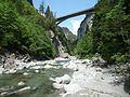
The bridge in Viamala designed by Christian Menn

A13 near Splügen

Entering the San Bernardino tunnel

A13 below Mesocco


Web links
- Photo series A13 on Autobahn.ch
- Photo series A13 on Autobahn-Bilder.de
- Andreas Simmen: San Bernardino - The Gotthard's little brother turns 50 In: Neue Zürcher Zeitung from October 6, 2017
Individual evidence
- ↑ How did the tunnel get its name? In: Espresso (radio broadcast) . Broadcast by Radio SRF 1 on July 16, 2018, 03: 29-04: 07
- ^ Werner Pfiffner: About the construction of the national highways in the canton of St. Gallen . In: Schweizerische Bauzeitung . tape 84 , no. 22 , 1966, pp. 407-409 , doi : 10.5169 / seals-68922 ( e-periodica.ch ).
- ↑ Continuous four-lane Rhine valley route: Milestone in St. Gallen motorway construction . In: Neue Zürcher Zeitung . August 19, 2002, ISSN 0376-6829 ( nzz.ch [accessed October 24, 2017]).
- ↑ Section of the A13 officially opened by Federal Councilor Leuenberger: Rhine valley "death stretch" defused . In: Neue Zürcher Zeitung . August 19, 2002, ISSN 0376-6829 ( nzz.ch [accessed October 24, 2017]).
- ↑ Bündner Monatsblatt Chronik 1973 ( Memento of the original from August 28, 2016 in the Internet Archive ) Info: The archive link was automatically inserted and not yet checked. Please check the original and archive link according to the instructions and then remove this notice.
- ↑ Federal Councilor Doris Leuthard opens the new Roveredo bypass , Federal Roads Office FEDRO, accessed on May 6, 2018
- ↑ Start of construction of the new A13 north lane Chur-Zizers. In: Southeastern Switzerland. October 10, 2014, accessed on May 25, 2015 : “The north lane was created in the 1950s. In the 1970s, the south lane was built as part of the national highway expansion - but not parallel to the existing north lane. "
- ↑ New Roveredo bypass opened , SRF, November 7, 2016
- ↑ On Pentecost Sunday, too, it jams in front of the Gotthard. In: look. May 20, 2018. Retrieved May 20, 2018 .
- ↑ A13, unsuitable for heavy traffic, to the Graubünden Civil Engineering Office (PDF; 383 kB)
- ^ Viamala bridge of the N 13: Project Christian Menn