
Splügen GR
| GR is the abbreviation for the canton of Graubünden in Switzerland and is used to avoid confusion with other entries of the name Splügen . |
| Splügen | ||
|---|---|---|
 |
||
| State : |
|
|
| Canton : |
|
|
| Region : | Viamala | |
| Political community : | Rheinwald | |
| Postal code : | 7435 Splügen 7436 Medels in the Rhine Forest |
|
| former BFS no. : | 3694 | |
| Coordinates : | 744 528 / 157482 | |
| Height : | 1457 m above sea level M. | |
| Area : | 60.49 km² | |
| Population density : | 6 inhabitants per km² | |
| Website: | www.rheinwald.ch | |
 Splügen GR |
||
| map | ||
|
||


Splügen (in local dialect [ ˈʃplyːg̊ə ], Rhaeto-Romanic Spleja / Spligia ) was a political municipality in the Viamala region in the Swiss canton of Graubünden until December 31, 2018 .
On January 1, 2019, Splügen merged with Hinterrhein and Nufenen to form the municipality of Rheinwald .
geography


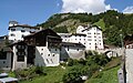
The village of Splügen is located at an altitude of 1,457 m in the Rhine Forest on the Hinterrhein and at the junction of the routes to the Splügenpass and San Bernardino passes . Both passes were already used as connecting routes to Italy in Roman times. The most striking hotel is the Hotel Bodenhaus , built in 1722 .
The Hüscherenbach flows from the side valley to the Splügen Pass into the Hinterrhein near Splügen.
Since January 1, 2006, the previously independent municipality of Medels in the Rheinwald has also belonged to Splügen . Medels is located between Splügen and Nufenen and was previously the smallest political municipality in the valley in terms of both area and population. Adjacent communities are Madesimo ( Italy ), Mesocco , Nufenen , Safien and Sufers .
The place Splügen has developed into a small winter sports resort and also attracts tourists because of the intact historic village center; In 1995, Splügen received the Wakker Prize , which is awarded by the Swiss Homeland Security for exemplary protection of the townscape. To the east of the village are the ruins of the former Splügen Castle . On the way to the castle, around 100 meters east of the Reformed Church , was the church of St. Urban and Vincentius until the beginning of the 19th century .
The Splügen Limestone Mountains rise north of Splügen .


coat of arms
Blazon : In red over a silver (white) bordered blue, wavy beam, a silver tin tower
The river band, which occurs as a motif in almost all Rheinwald communities, is supplemented by the pinnacle tower as a reference to the castle in Splügen. The colors of the coat of arms are derived from the coat of arms of the barons of Vaz .
Coat of arms of the former municipality of Medels in the Rheinwald: Blazon: In red over a silver (white) bordered blue wavy bar, the silver letter M Next to the first letter of the community, the wavy bar as a symbol for the valley.
history
The place name appears as Speluca in a list of the Carolingian emperors from 831, only preserved as a copy from the 16th century , in the 13th / 14th. In the 19th century it appears as Speluga / Spluͥgen / Spluͥga . It goes back to Latin spelunca 'cave, which is still preserved in dialects of Italian alliances as splüg , overhanging rock / cave.
The places in the Rhine Forest, originally located in the Romansh-speaking area, were settled by German-speaking Walsers from the south over the San Bernardino Pass in the late 13th century . From the late Middle Ages to the 19th century, the transport of goods was the main source of income for the local population; most of them lived directly or indirectly from the mule being .
In 1716 and 1751, the village of Splügen was largely destroyed by fires and rebuilt on the remaining foundation walls.
From 1818 to 1823 the mule tracks over the Splügen and the San Bernardino Pass were expanded almost simultaneously into so-called commercial roads, which led to an increase in the transit of goods and people. The reason was the rivalry between Piedmont and Austrian Lombardy , so that Lombardy expanded the Splügen Pass on its own account, while Piedmont only had to participate in the Graubünden project - the bridge dedicated to King Vittorio Emanuele south of San Bernardino was only a short landmark . The project of a rail connection through Graubünden had shifted to the Lukmanier Pass and was subject to the Gotthard Railway. With the opening of the Gotthard tunnel in 1882, many locals lost their work and income opportunities; The transport of goods fell from 14,000 tons to 1,000 tons within a short period of time. Many emigrated and sought their fortune in the USA or New Zealand.
At the time of the Second World War , the intention was to sink Splügen, Medels and Nufenen in a huge reservoir. The 700 meter long and 150 meter high dam would have been built near the castle ruins of Splügen ; a smaller dam at Sufers . Violent resistance from the population prevented the project and on November 29, 1946, the Rheinwald reservoir project was rejected by the Federal Council after years of legal dispute.
During the Second World War, the Splügen barrier was created in the village and near the castle .
A new chapter in the history of the pass village of Splügen began in 1967 with the opening of the road tunnel through the San Bernardino. Splügen benefited from the increased volume of traffic and developed into a winter and summer vacation spot. From then on it became very quiet on the Splügen Pass, which was closed in winter, which is why it is an excellent example for those interested in culture and history due to the preserved engineering structures on First Street. The Swiss got involved in the preservation of the historical townscape in 1973 by buying chocolate bars .
population
| Population development | |||||||||||||
|---|---|---|---|---|---|---|---|---|---|---|---|---|---|
| year | 1690 | 1850 | 1900 | 1930 | 1950 | 1980 | 1990 | 2000 | 2005 | 2010 | 2012 | 2014 | 2016 |
| Residents | 360 | 494 | 373 | 336 | 387 | 415 | 415 | 411 | 401 | 405 | 406 | 384 | 377 |
languages
The community was settled by Walsers around 1290 and has therefore been one of the German-speaking places in the canton of Graubünden for centuries. German is the only official language. The following table shows the development in Splügen (with Medels) over the past decades:
| Languages in Splügen | ||||||
| languages | 1980 census | 1990 census | 2000 census | |||
| number | proportion of | number | proportion of | number | proportion of | |
| German | 350 | 84.34% | 364 | 87.71% | 369 | 89.78% |
| Romansh | 30th | 7.23% | 18th | 4.34% | 8th | 1.95% |
| Italian | 20th | 4.82% | 9 | 2.17% | 11 | 2.68% |
| Residents | 415 | 100% | 415 | 100% | 411 | 100% |
Origin and nationality
Of the 401 residents of the (old) community at the end of 2005, 353 (= 88%) were Swiss nationals. Of the 446 inhabitants (including Medels in the Rheinwald), 395 (= 89%) were Swiss citizens.
traffic

Splügen is on the A13 motorway and is connected to the public transport network with the post bus line (Chur–) Thusis – Bellinzona. Buses operated by the Italian company STPS drive over the Splügen Pass to Valle San Giacomo and Chiavenna .
economy

Splügen is still characterized by agriculture. Four hotels and some restaurants offer accommodation and meals. A butcher, a Volg and the Splügen Dairy, where local products are on offer, are available for shopping . Tourism plays an important role, especially in winter: several cable cars lead to the Pizzo Tambo ski area .
regional customs
The Pschuuri is celebrated every year on Ash Wednesday .
Attractions
In addition to the well-preserved village image with its old houses, there are the following sights in and around Splügen:
- The Reformed Church of Splügen
- The parish hall
- The Bodenhaus and Weiss Kreuz hotels
- The splügen castle
- The former customs building
- The marble bridge on the road to the Splügen Pass
- The restored Splügen Gallery below the top of the pass
- Old tunnel with a pointed barrel above today's road over the Splügen Pass
- A popular hiking destination is the Upper Surettasee

View from the pass road
Stutzbach

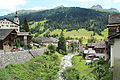
Splügen from the west
old part of the village to the right of the Stutzbach


literature
- Bündner Monatsblatt 4/2016: Battle of the Rheinwald : The end of the large Splügen / Rheinwald power plant
- Kurt Wanner: Splügen. In: Historical Lexicon of Switzerland . 2013 .
Web links
- Splügen GR on the ETHorama platform
- Official website of the municipality of Splügen
- Federal inventory ISOS: Splügen
- Splügen: ASTi, catalogo dei fondi fotografici
- Alfred Wyss: Splügen, a village complex worth preserving . Heimatschutz magazine 1973, issue 3
Individual evidence
- ↑ Andres Kristol: Splügen GR (Hinterrhein) in: Dictionnaire toponymique des communes suisses - Lexicon of Swiss municipality names - Dizionario toponomastico dei comuni svizzeri (DTS | LSG). Center de dialectologie, Université de Neuchâtel, Verlag Huber, Frauenfeld / Stuttgart / Vienna 2005, ISBN 3-7193-1308-5 and Éditions Payot, Lausanne 2005, ISBN 2-601-03336-3 , p. 848.
- ↑ Hinterrhein power plants
- ↑ Via Spluga
- ↑ Splügen Dairy ( Memento of the original from April 19, 2015 in the Internet Archive ) Info: The archive link was inserted automatically and has not yet been checked. Please check the original and archive link according to the instructions and then remove this notice.
- ↑ Tambo ski area ( Memento of the original from March 15, 2015 in the Internet Archive ) Info: The archive link was inserted automatically and has not yet been checked. Please check the original and archive link according to the instructions and then remove this notice.
- ↑ The parish hall
- ↑ The former customs building
- ↑ The tunnel with the pointed barrel
Andeer | Obverse | Casti-Wergenstein | Cazis | Domleschg | Donat | Ferrera | Flerden | Fürstenau | Wages | Masein | Mathon | Rheinwald | Rongellen | Rothenbrunnen | Sharans | Sils im Domleschg | Sufers | Thusis | Tschappina | Urmein | Zillis-Reischen . Former municipalities: Almens | Ausserferrera | Casti | Clugin | Donath | Feldis / Veulden | Hinterrhein | Innerferrera | Medels in the Rheinwald | Mutten | Nufenen | Piping | Patzen-Fardün | Pignia | Portein | Pratval | Prec | Reischen | Sledges | Sarn | Scheid | Splügen | Tartare | Tomils | Trans | Tumegl / Tomils | Wergenstein | Zillis .