Casti-Wergenstein
| Casti-Wergenstein | |
|---|---|
| State : |
|
| Canton : |
|
| Region : | Viamala |
| BFS no. : | 3703 |
| Postal code : | 7433 |
| Coordinates : | 751 733 / 165 665 |
| Height : | 1489 m above sea level M. |
| Height range : | 1019-3047 m above sea level M. |
| Area : | 25.62 km² |
| Residents: | 56 (December 31, 2018) |
| Population density : | 2 inhabitants per km² |
|
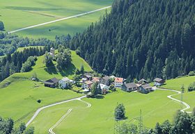
Casti village |
|
| Location of the municipality | |
Casti-Wergenstein ( Romansh Casti-Vargistagn ) is a municipality in the Viamala region of the Swiss canton of Graubünden .
coat of arms
Blazon : In silver (white) on black Three rock a red castle tower, beseitet of two six-pointed red stars
The coat of arms refers to the name of the municipality: the castle tower stands for Casti, the Dreifels for (Wergen) stone.
geography
The community consists of the widely separated districts of Casti (1125 m) and Wergenstein (1489 m) on the lower Schamserberg. Of the total municipal area of 2559 hectares, 1343 hectares are used for agricultural purposes (1275 hectares of which are Alpine farms), 998 hectares of unproductive area (mostly mountains), 203 hectares of forest and wood and 15 hectares of settlement area.
Casti-Wergenstein borders on Andeer , Clugin , Donat GR , Mathon GR , Safien and Sufers .
population
languages
The original language of the inhabitants is Sutselvisch , a Graubünden Romance dialect. The community remained almost monolingual until the First World War. Thereafter, Romansh began to decline by the Second World War (74% in 1941), but this was reversed by 1980: in 1970, 83% spoke Romansh. Since the 1980s, there has been a change of language due to the immigration of German-speaking people:
| Languages in Casti-Wergenstein | ||||||
| languages | 1980 census | 1990 census | 2000 census | |||
| number | proportion of | number | proportion of | number | proportion of | |
| German | 7th | 19.44% | 14th | 32.56% | 24 | 42.86% |
| Romansh | 29 | 80.56% | 29 | 67.44% | 31 | 55.36% |
| Residents | 36 | 100% | 43 | 100% | 56 | 100% |
Romansh and German are official languages on an equal footing. The official language according to the cantonal language law of 2006 is only Romansh.
nationality
Of the 61 residents at the end of 2005, all were Swiss citizens.
politics
The current mayor is Marco Dolf.
history
Casti was already settled in the early Middle Ages. A first church was built in the 12th century, a free farming community in the 13th century. The Reformation was introduced in the 1530s. Wergenstein was in the 6./7. Settled in the 18th century and introduced the Reformation shortly after Casti. In the church of Casti there are frescoes by the Waltensburg master .
Today's municipality was created in 1923 from the merger of the municipalities of Casti and Wergenstein.
Attractions
In addition to the church in Casti, the Wergenstein church is also a listed building.
The Center da Capricorns is a rural information and innovation center.
Wergenstein Church
literature
- Jürg Simonett: Wergenstein. In: Historical Lexicon of Switzerland .
Web links
Individual evidence
- ↑ Permanent and non-permanent resident population by year, canton, district, municipality, population type and gender (permanent resident population). In: bfs. admin.ch . Federal Statistical Office (FSO), August 31, 2019, accessed on December 22, 2019 .
- ↑ Language law of the Canton of Graubünden of October 19, 2006 (PDF; 274 kB).


