Ausserferrera
| Ausserferrera | ||
|---|---|---|
| State : |
|
|
| Canton : |
|
|
| Region : | Viamala | |
| Political community : | Ferrera | |
| Postal code : | 7444 | |
| Coordinates : | 752 966 / 157 355 | |
| Height : | 1316 m above sea level M. | |
| Area : | 31.51 km² | |
| Residents: | 46 (December 31, 2007) | |
| Population density : | 1 inhabitant per km² | |
| Website: | www.ferrera.ch | |
|
Ausserferrera |
||
| map | ||
|
|
||
Ausserferrera (Rhaeto-Romanic Farera and Feraila ) is a fraction of the municipality of Ferrera GR in the south of the former Hinterrhein district of the canton of Graubünden in Switzerland . On January 1, 2008, she was with the municipality Innerferrera to the municipality Ferrera merged .
coat of arms
Description: In silver, a black miner's hammer placed diagonally on the right. The significant mining in Ausser- und Innerferrera led to the choice of the miner's hammer as the coat of arms for both communities in the colors of the Gray League.
geography
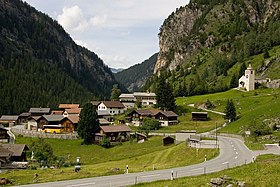
Ausserferrera is located on the Averser Rhine ( Romanesque : Ragn da Ferrera) in Val Ferrera . The village consists mostly of old wooden houses. The Cresta settlement, which is only inhabited in summer, is located on a terrace 350 m above the village. On the left side of the valley the local area extends up to the 2855 m high Hüreli, on the right side of the valley up to the 3060 m high Piz Grisch . 50% of the local area is unproductive, 20% is forested and 29% is used for agriculture.
Surname
Ausserferrera, Romanesque Farera, got its name from the iron mines that used to be operated here (Latin: ferraria ).
geology
The rock walls in Ausserferrera be of the Penninic rocks of Suretta- ceiling , in particular from Rofna- gneiss - formed - a porphyry gneiss. Triassic sedimentary rocks are wedged into the Rofna gneiss . The latter stand below the village of Ausserferrera as dolomite and pull up towards Cresta. The village of Ausserferrera lies on a steep debris flow - debris cone .
history
The early history of Ausserferrera was shaped by ore mining. Evidence shows that ore has been mined since the 16th century . Mining was the most intensive in the 19th century. Copper ore containing silver was mined, as evidenced by the remains of a furnace below Ausserferrera. As a result of mining and smelting , the valley was largely deforested.
In the 20th century, the development was characterized by the construction of electricity plants in the Hinterrhein area. During the work, a multiple number of people also lived in the valley. Today the community still benefits from the water interest from the Hinterrhein power plants .
population
Population development
The population development of Ausserferrera reflects the constant migration from the mountain area. The village experienced an upswing around 1850 thanks to mining and around 1960 with the construction of power plants.
| Population development | |||||||||||
|---|---|---|---|---|---|---|---|---|---|---|---|
| year | 1808 | 1850 | 1900 | 1910 | 1960 | 1970 | 1980 | 1990 | 2000 | 2005 | 2007 |
| Residents | 110 | 167 | 107 | 78 | 219 | 45 | 50 | 48 | 47 | 49 | 46 |
languages
The community was settled by Graubünden novels in the 11th century . The residents spoke Sutselvian . Until around 1900 the community was almost monolingual (1880 98.4%, 1900 98.13% Romanes). Romansh was the majority language until 1950 (1941 58. 8%). After that, a slow change in language began. German has been the most important language since 1970. In the 1990s, a complete language change began, as the following table shows:
| Languages in Ausserferrera GR | ||||||
| languages | 1980 census | 1990 census | 2000 census | |||
| number | proportion of | number | proportion of | number | proportion of | |
| German | 29 | 58.00% | 28 | 58.33% | 44 | 93.62% |
| Romansh | 19th | 38.00% | 17th | 35.42% | 1 | 2.13% |
| Italian | 0 | 0.00% | 2 | 4.17% | 1 | 2.13% |
| Residents | 50 | 100% | 48 | 100% | 47 | 100% |
Today, German is the only official language, although 23.4% of the population still understand Romansh.
Origin and nationality
Of the 49 residents at the end of 2005, 45 (= 91.84%) were Swiss citizens.
Culture and sights
The reformed village church of Ausserferrera dates - with the exception of possible 15th century components - from the year 1718. The oldest branch church in the valley is in the terraced settlement of Cresta . It was probably built around 1200.
Economy and Infrastructure
Ausserferrera offers few jobs in agriculture and forestry as well as in service companies. The village is connected to the main town of the Schams Andeer district by postbus courses .
literature
- Jürg Simonett: Ausserferrera. In: Historical Lexicon of Switzerland . 2016 .
Web links
- Ausserferrera on the ETHorama platform
Individual evidence
- ↑ Holiday Book of Switzerland, ed. by the Schweizer Rekakasse with the support of the Swiss Traffic Center, Bern 1977, p. 547


