Tschappina
| Tschappina | |
|---|---|
| State : |
|
| Canton : |
|
| Region : | Viamala |
| BFS no. : | 3669 |
| Postal code : | 7428 |
| Coordinates : | 748 765 / 172078 |
| Height : | 1500 m above sea level M. |
| Height range : | 1029–2998 m above sea level M. |
| Area : | 24.67 km² |
| Residents: | 130 (December 31, 2018) |
| Population density : | 5 inhabitants per km² |
| Website: | www.tschappina.ch |
|
Group of houses in Tschappina |
|
| Location of the municipality | |
Tschappina is a municipality in the Viamala region in the Swiss canton of Graubünden .
geography
Tschappina is located at the foot of Piz Beverin and is the starting point of the mule track over the Glaspass into Safiental . Tschappina is a scattered village . It is divided into the village parts of Untertschappina (1400 m above sea level), Obertschappina (1580 m above sea level) and the three fractions Obergmeind (1810 m above sea level), Ausserglas (1846 m above sea level) and Innerglas (1820 m above sea level). In the Obergmeind there is a small, avalanche-proof ski area with three ski lifts. In summer there are numerous hikes and mountain tours from Tschappina. The abandoned settlement of Masügg lies to the south above the village .
Tschappina is one of the eleven communities in the Beverin Nature Park .
coat of arms
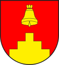
Blazon : In red over a golden (yellow) stepped gable a golden bell
The bell dedicated to Saint Theodul , to whom a chapel was dedicated , hangs above the stepped gable as a reference to the ascent to the Glaspass, also called Scala or Stäga .
history
The place name is first found in a document in 1396 as in Schipinen or in Stipinen and in 1448 as uff Tschuppinen . It corresponds to the Graubünden Romanic generic word Tschuppina, which means "cleared parcel" and is derived from Tschep " Tree trunk, chopping stick, thick piece of wood" (from Latin cipus "boundary stone, pile").
The place was settled in the 14th century by the most Alemannic- speaking Walsers from the Safien valley. Until the 20th century, contact with the Safi people across the Glaspass was closer than that with the Rhaeto-Romanic Heinzenberg and Domleschg . The road to Thusis in Domleschg was not built until 1900/1901.
After 1515 Tschappina introduced the Reformation . Until 1851 the community formed its own judicial community in the Gray League .
population
| Population development | ||||||||||||
|---|---|---|---|---|---|---|---|---|---|---|---|---|
| year | 1803 | 1850 | 1900 | 1950 | 1980 | 1990 | 2000 | 2005 | 2010 | 2012 | 2014 | 2016 |
| Residents | 330 | 251 | 209 | 209 | 156 | 140 | 151 | 160 | 141 | 137 | 128 | 128 |
languages
The place has belonged to the German-speaking communities of the Canton of Graubünden since the late Middle Ages (see chapter History). This is also shown in the table below:
| languages | 1980 census | 1990 census | 2000 census | |||
|---|---|---|---|---|---|---|
| number | proportion of | number | proportion of | number | proportion of | |
| German | 151 | 96.79% | 138 | 98.57% | 148 | 98.01% |
| Romansh | 3 | 1.92% | 2 | 1.43% | 2 | 1.32% |
| Residents | 156 | 100% | 140 | 100% | 151 | 100% |
Origin and nationality
Of the 160 residents at the end of 2005, 153 were Swiss citizens.
Attractions
The reformed village church is a listed building .
Personalities
- Reto Hänny (* 1947), writer
- Luzi Jenny (1925–2015), dialect writer
- Oscar Plattner (1922–2002), racing cyclist
literature
- Erwin Poeschel : The art monuments of the canton of Graubünden III. The valley areas Räzünser Boden, Domleschg, Heinzenberg, Oberhalbstein, Upper and Lower Engadine (= Swiss art monuments. Volume 11). Edited by the Society for Swiss Art History GSK. Bern 1940. DNB 760079625 .
- Jürg Simonett: Tschappina. In: Historical Lexicon of Switzerland . 2014 .
Web links
- Tschappina on the ETHorama platform
- Official website of the Tschappina municipality
Individual evidence
- ↑ Permanent and non-permanent resident population by year, canton, district, municipality, population type and gender (permanent resident population). In: bfs. admin.ch . Federal Statistical Office (FSO), August 31, 2019, accessed on December 22, 2019 .
- ^ Rhaetian name book . Arranged by Andrea Schorta. Volume II, Bern 1964, p. 94. According to this lexicon of Swiss community names . Edited by the Center de Dialectologie at the University of Neuchâtel under the direction of Andres Kristol. Frauenfeld / Lausanne 2005, p. 887.


