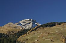
Piz Beverin
| Piz Beverin | ||
|---|---|---|
|
Piz Beverin seen from Heinzenberg |
||
| height | 2998 m above sea level M. | |
| location | Canton of Graubünden , Switzerland | |
| Mountains | Alps (Eastern Alps) | |
| Dominance | 4.1 km → Bruschghorn | |
| Notch height | 392 m ↓ Carnusapass | |
| Coordinates | 746 894 / 168603 | |
|
|
||
| Normal way | Over the southern slope | |


The Piz Beverin ( ) is one of the most distinctive and popular panoramic mountains in the Central Grisons region in Switzerland .
geography
location
The mountain forms the northern end of the Schamser ceiling between Schams and Safiental . In the east it flanks the Viamala . The mountain forms the natural border between the political communities Tschappina and Mathon GR .
height
According to Swisstopo (sheet 1235, 1: 25,000, 2003) the top of Piz Beverin is 2998 m above sea level. M.
geology
The Piz Beverin belongs together with the Splügener Kalkberge to the Schamserdecke and is of Penninic origin. Unlike the Splügen limestone mountains, which mainly consist of dolomite and marbled limestone from the Triassic period , the Beverin has a sequence of layers of limestone, marble and quartzite . The pubic cover was pushed onto the underlying Bündner slate when the Alps were folded .
fauna
Wolves
The wolf pack on Piz Beverin had 2019 includes early October, two parents and a total of nine pups. At the same time, the canton of Graubünden ordered the herd to be regulated, as one parent had torn at least 15 goats from protected flocks. Four young animals were shot by November 2019, one of which was previously seriously injured in a game accident .
history
Origin of the name
The name Beverin comes from "bovarinum", which in turn is derived from the Latin "bos" (cattle, ox). Thus the Beverin is the "Ochsenberg".
First ascent
Most of the routes are not known to have climbed the first time.
Routes to the summit
Piz Beverin can be reached via various easy (mountain hiking trails) to fairly difficult routes. The mountain is a popular ski and snowboard tour destination. It is usually approached from the Glaspass , from Mathon GR or from Wergenstein .
Summer routes
Through the west flank
The path is marked, steep and partly exposed. He is tricky in ice and wet conditions. The route is ice-free from around mid-June.
- Difficulty: T4 (marked white-blue-white)
- Time required: 3.5 hours from the Glaspass (1,846 m)
- Starting point: Glaspass (1,846 m)
Over the southern slope
Technically the easiest. Leads over the white-red-white marked mountain hiking trail to the Beverin gap. From there on the same route as through the western flank.
- Difficulty: T3 (marked white-red-white)
- Time required: 3 hours from Alp Tumpriv (2,114 m)
- Starting point: Mathon GR (1'547 m)
Over the southeast ridge
About the Beverin Pintg. The route is also accessible in winter and leads over a six meter high ladder.
- Difficulty: T3 (marked white-red-white)
- Time required: 3 hours from Alp Tumpriv (2,114 m) or from Mursenas (1,932 m)
- Starting point: Mathon GR (1'547 m)
Over the southwest ridge
From Carnusapass over the Runal to the saddle 2'625 m and then northwards to the gap. Then follow the route over the western flank.
- Difficulty: T4 (not marked)
- Time required: 1.5 hours from Carnusapass (2'605 m)
- Starting point: Mathon GR (1'547 m) or Wergenstein (1'487 m)
Over the northwest ridge
Not recommended route. The rock is very brittle and the (short) climbing spots are accordingly tricky. In addition, it must be expected that ibexes trigger rockfalls.
- Difficulty: ZS (not marked)
- Time required: 4 hours from the Glaspass (1,846 m)
- Starting point: Glaspass (1,846 m)
- First ascent: September 20, 1908 by Carl Frey
Over the east ridge
The direct route from Thusis . Hardly done today.
- Difficulty: T4 (not marked)
- Time required: 7 hours from Thusis (697 m), 3.5 hours from the Scherenkopf (2,117 m)
- Starting point: Thusis (697 m)
panorama
literature
- Manfred Hunziker: Club guide Bündner Alpen 2, From Lukmanier to Domleschg. SAC Verlag, 5th edition 1996, ISBN 3-85902-154-0
Web links
- Piz Beverin on the ETHorama platform
- Panorama from Piz Beverin
- Piz Beverin tour reports
- Tour description on www.heinzenberg.ch
Individual evidence
- ↑ Pack from Beverin - Now the fourth young wolf is also dead. In: srf.ch. November 25, 2019, accessed November 25, 2019 .


