
Carnusapass
| Carnusapass | |||
|---|---|---|---|
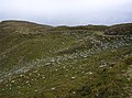
 Carnusapass in the gap to the left of Piz Tarantschun, seen from the north (Safien side) |
|||
| Compass direction | northwest | Southeast | |
| Pass height | 2605 m above sea level M. | ||
| Canton | Grisons | Grisons | |
| Watershed | (Carnusabach, Rabiusa , Vorderrhein , Rhine ) | ( Hinterrhein , Rhine ) | |
| Valley locations | Safien Platz / Safiental | Wergenstein / Schams | |
| expansion | Widened mule track | ||
| Mountains | Splügen limestone mountains | ||
| map | |||
|
|||
| Coordinates | 745 987 / 166691 | ||

The Carnusapass is a mountain pass in the Adula Alps in the canton of Graubünden . At an altitude of 2605 m above sea level. M. it connects the places Safien and Wergenstein . A mule track leads over the pass . On both sides of the top of the pass, the path is noticeably developed with hairpin bends, which are usually shortened by hikers because they are too flat for them. The expansion was possibly related to Army trains during World War II. The pass lies between the Piz Tarantschun ( 2769 m ) in the southwest and the Runal ( 2705 m ) in the northeast. Piz Beverin lies further to the northeast .
Expansion on the Wergenstein side
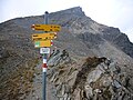
Pass height


Albrun | Antrona | Augstbord | Balme | Barna | Bocchetta di Val Maggia | Boeuf | Bunder bark | Carmenna | Carnusa | Casanna | Chaschauna | Chésery | Cheville | Chräzeren | Chrüzli | Corno | Cristallina | Cou | Diesrut | Durand | Duranna | Encel | Euschels | Ferret Grand | Ferret Petit | Foo | Fórcola | Fuorcla Surlej | Fuorcla da Patnaul | Furcletta | Futschöl | Goat path | Gemmi | Giümela | Gredigs Fürggli | Greina | Semolina | Grünenberg | Güner Lückli | Gurin Furggu | Heidel | Heubützli | Hörnligrat | Illsee | Yoke | Jorat | Kinzig | Boxes | Kleine Scheidegg | Lona | Soldering | Lys | Maienfelder Furgga | Meidpass | Menouve | Monte Moro | Muretto | Naret | Niemet | Panixer | Pontimia | Rawil | Redorta | Riseten | Rotstein | Saas | Safierberg | Saflish | San Giacomo | San Jorio | Saddle | Scaletta | Schlappiner yoke | Schnidejoch | Schonegg | Schwialp | Segnes | Septimer | Sertig | Soladier | Soreda | Stallerberg | Strela | Surene | Susanfe | Tamier | Theodule | Tomül | Torrent | Trescolmen | Trütlisberg | Urdenfürggli | Valserberg | Zeblasjoch | Between mountains