Muretto Pass
| Muretto Pass | |||
|---|---|---|---|
|
View to the Murettopass (facing south) |
|||
| Compass direction | North | south | |
| Pass height | 2562 m slm | ||
| region | Canton of Graubünden , Switzerland | Sondrio Province , Italy | |
| Watershed | Orlegna , Mera | Mallero | |
| Valley locations | Maloja | Chiesa in Valmalenco | |
| expansion | trail | ||
| Mountains | Bernina Alps | ||
| map | |||
|
|
|||
| Coordinates , ( CH ) | 46 ° 20 '56 " N , 9 ° 44' 1" O ( 776 650 / 135 631 ) | ||
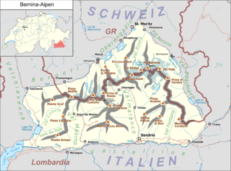
The 2,562 m high Muretto ( ital . Passo del Muretto ) located between the Bernina range and the southern mountains of Bergell . A hiking trail connects the Engadine Malojapass over the Valmalenco with Sondrio in Valtellina .
history
A raid from Valmalenco that led over the Murettopass has been handed down as early as 1375 . After troops from the Engadine invaded Valtellina in 1618 , two years later refugees from the Valtellina took the opposite route.
In the middle of the 19th century the pass lost its previous meaning. This was due to new customs regulations in Switzerland after 1848 and the high burden on Swiss products from the customs of the Austrian Kingdom of Lombardy-Veneto . While in 1814 70,000 Saum wines were brought from the Valtellina to Switzerland at Muretto , along with all sorts of other regional products, after 1848 it was only a little cattle and other agricultural products. But even before that, traffic on the Muretto suffered a severe setback when a storm in 1834 destroyed large parts of the route and was not soon restored. Ultimately, this was probably the reason why the Muretto did not have a customs post, since their demand was measured against the current traffic. In the second half of the 19th century, the advance of the glaciers from Pizzo dei Rossi and Monte del Forno threatened to make the path impassable. The early editions of the Dufour map show that the route on the Italian and Swiss sides had to be over the glacier. However, by 1890 at the latest, the pass was again free of ice.
Ultimately, the path was poorly restored so that it was safe for pedestrians and cattle drives. That has not changed to this day, which is why today only hikers and mountain bikers use the path. Pedestrians can cover the pass relatively comfortably in 5 to 6 hours.
literature
- Martin Bundi: Murettopass. In: Historical Lexicon of Switzerland . March 9, 2017 .
Individual evidence
- ↑ Steffan Bruns: Alpine passes - history of the alpine pass crossings. From the Inn to Lake Garda . 1st edition. tape 3 . L. Staackmann Verlag, Munich 2010, ISBN 978-3-88675-273-7 , p. 109 .

