
Fuorcla Surlej
| Fuorcla Surlej | |||
|---|---|---|---|
 Bernina range from Fuorcla Surlej |
|||
| Compass direction | west | east | |
| Pass height | 2753 m above sea level M. | ||
| Canton | Grisons | Grisons | |
| Watershed | Ova da Roseg → Inn | Ova da Schinellas → Inn | |
| Valley locations | Sils in the Engadin / Segl | Pontresina | |
| map | |||
|
|||
| Coordinates | 784 536 / 144797 | ||

The Fuorcla Surlej is a pass and a mule track in the Swiss Alps . It connects the Upper Engadin with the Val Roseg , both in the canton of Graubünden . It is an often used transition with a hiking trail (marked white-red-white) from Sils in Engadin / Segl or Surlej to Pontresina (Val Roseg). From Fuorcla Surlej you have a good view of the Bernina group and its glaciers.
Fuorcla Surlej can be reached from Surlej with the Piz Corvatsch cable car. The Murtèl middle station ( 2698 m above sea level ) is around 1½ kilometers from Fuorcla Surlej. In summer the Coazhütte can be reached on a hiking trail from the valley station in around 2 ½ hours.
gallery
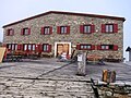
Mountain house Fuorcla Surlej

Fuorcla Surlej, view of the Bernina range
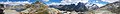
Fuorcla Surlej, panorama
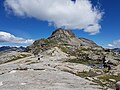
Fuorcla Surlej, Munt Arlas

Fuorcla Surlej, Piz Tschierva

Fuorcla Surlej, Bernina Group


Web links
Individual evidence
Albrun | Antrona | Augstbord | Balme | Barna | Bocchetta di Val Maggia | Boeuf | Bunder bark | Carmenna | Carnusa | Casanna | Chaschauna | Chésery | Cheville | Chräzeren | Chrüzli | Corno | Cristallina | Cou | Diesrut | Durand | Duranna | Encel | Euschels | Ferret Grand | Ferret Petit | Foo | Fórcola | Fuorcla Surlej | Fuorcla da Patnaul | Furcletta | Futschöl | Goat path | Gemmi | Giümela | Gredigs Fürggli | Greina | Semolina | Grünenberg | Güner Lückli | Gurin Furggu | Heidel | Heubützli | Hörnligrat | Illsee | Yoke | Jorat | Kinzig | Boxes | Kleine Scheidegg | Lona | Soldering | Lys | Maienfelder Furgga | Meidpass | Menouve | Monte Moro | Muretto | Naret | Niemet | Panixer | Pontimia | Rawil | Redorta | Riseten | Rotstein | Saas | Safierberg | Saflish | San Giacomo | San Jorio | Saddle | Scaletta | Schlappiner yoke | Schnidejoch | Schonegg | Schwialp | Segnes | Septimer | Sertig | Soladier | Soreda | Stallerberg | Strela | Surene | Susanfe | Tamier | Theodule | Tomül | Torrent | Trescolmen | Trütlisberg | Urdenfürggli | Valserberg | Zeblasjoch | Between mountains