
Passo della Greina
| Passo della Greina / Pass Crap / Greinapass | |||
|---|---|---|---|
 View of the Greina plateau to the southwest |
|||
| Compass direction | west | east | |
| Pass height | 2354 m above sea level M. | ||
|
|
|
|
|
| Watershed | Brenno | In there Sumvitg | |
| Valley locations | Olivone | Sumvitg | |
| expansion | trail | ||
| Mountains | Adula Alps | ||
| map | |||
|
|||
| Coordinates | 716 543 / 163243 | ||

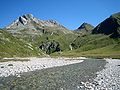
The Passo della Greina ( Rhaeto-Romanic , German Greinapass ) lies on the border between the Swiss cantons of Ticino in the west and Graubünden in the east at an altitude of 2354 m above sea level. M. in the Adula Alps . Together with the Lukmanier Pass , it was already used by the Romans .
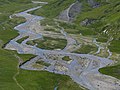
Greina plateau
The Greina region, in Graubünden Romanesque Plaun la Greina , is a plateau approximately six kilometers long and one kilometer wide at an altitude of around 2200 meters, through which the meandering Rein da Sumvitg flows in the northern part . The untouched natural landscape became known in 1948/49 and 1985, when protests were made across the country against a hydroelectric power plant project with a reservoir in the Greina. Due to the higher possible gradient, the water of the area belonging to the northern catchment area of the Rhine on the southern side of the Alps would have been turbined. The first concession was awarded in 1916, and construction was scheduled to start in 1991 for the last project. It was withdrawn on December 22, 1986.
The biotope diversity of the plain is extraordinary and unique. In 1996 the Greina level was included in the federal inventory of landscapes and natural monuments of national importance as a protection zone .
Popular bases for hikes are the Terrihütte , built in 1925 , owned by the Piz Terri section of the Swiss Alpine Club in a separate area chamber north of the plain, and the Motterasciohütte , owned by the Ticino section in the south of the Greina plain. West of the Greina Pass is the Capanna Scaletta of the Società Alpinistica Ticinese SAT.
The Greina plain was to become part of the Parc Adula planned for 2015 . He failed in the vote.
The fourth stage of the Alpine Passes Trail (national route 6 of the Swiss hiking trails ) leads through the plain and over the pass .
Accesses
There are various approaches and tour options in the area. In summer, Greina and Terrihütte can be reached on hiking trails from the Grisons side from Vrin (PostBus) via Pass Diesrut, from Rabius (train station) through Val Sumvitg and via a somewhat steep ascent at Crest la Greina. In 2018, a 65-meter-long suspension bridge was built at the lower end of the Greina, spanning the Rein da Sumvitg at a height of 40 meters. This shortened the connection between Terrihütte and Greina by an intermediate climb.
From the Ticino side, the start is in Olivone (PostBus) or Campo . From there it goes either along the Lago di Luzzone to the Motterasciohütte and further over the Pass Crap, or the Val Camadra up to the Pass la Greina.
The regular Postbus routes are extended in summer by the “Bus Alpin”: from Vrin to Puzzatsch, from Rabius to Runcahez and from Olivone to Pian Geirett in Val Camadra.
gallery
Meander of the Rein da Sumvitg
View to the northeast, on the right behind the ascent to Pass Diesrut

View to the southwest
Greina Glacier

Pass Diesrut before descending to Vrin


See also
- Shipping canal projects in the Alps , via u. a. the unrealized Gotthard, Greina and San Bernardino canals
Web links
Individual evidence
- ↑ a b Spelling & height according to SwissTopo (maps of Switzerland)
- ↑ Capanna Scaletta. Retrieved May 29, 2020 .
- ↑ Punt la Greina suspension bridge. In: surselva.info. Retrieved May 29, 2020 .
- ↑ Bus alpin , accessed on May 29, 2020.
Albrun | Antrona | Augstbord | Balme | Barna | Bocchetta di Val Maggia | Boeuf | Bunder bark | Carmenna | Carnusa | Casanna | Chaschauna | Chésery | Cheville | Chräzeren | Chrüzli | Corno | Cristallina | Cou | Diesrut | Durand | Duranna | Encel | Euschels | Ferret Grand | Ferret Petit | Foo | Fórcola | Fuorcla Surlej | Fuorcla da Patnaul | Furcletta | Futschöl | Goat path | Gemmi | Giümela | Gredigs Fürggli | Greina | Semolina | Grünenberg | Güner Lückli | Gurin Furggu | Heidel | Heubützli | Hörnligrat | Illsee | Yoke | Jorat | Kinzig | Boxes | Kleine Scheidegg | Lona | Soldering | Lys | Maienfelder Furgga | Meidpass | Menouve | Monte Moro | Muretto | Naret | Niemet | Panixer | Pontimia | Rawil | Redorta | Riseten | Rotstein | Saas | Safierberg | Saflish | San Giacomo | San Jorio | Saddle | Scaletta | Schlappiner yoke | Schnidejoch | Schonegg | Schwialp | Segnes | Septimer | Sertig | Soladier | Soreda | Stallerberg | Strela | Surene | Susanfe | Tamier | Theodule | Tomül | Torrent | Trescolmen | Trütlisberg | Urdenfürggli | Valserberg | Zeblasjoch | Between mountains