Swiss hiking trails
| Swiss hiking trails | |
|---|---|
 Logo of the Swiss hiking trails
|
|
| sport | hike |
| Founded | 1934 |
| president | Werner Luginbühl |
| Board | Adèle Thorens Goumaz, Jürg Balsiger, Fulvio Sartori, Damian Tomaschett, Gabrielle Bakels |
| Association headquarters | Bern |
| Homepage | https://www.wandern.ch/ |
The Swiss hiking trails (formerly the Swiss working group for hiking trails , abbreviation SAW) is the umbrella organization of the cantonal hiking trail associations in Switzerland and Liechtenstein . Under the name Wanderland Schweiz , the hiking trails are also part of the SwitzerlandMobility project . Switzerland has a network of uniformly marked hiking trails with a length of over 65,000 km (2019), of which 14,000 km are hard surface and 21,000 km are mountain trails.
Tasks and facts
The SAW supports the cantonal hiking trail associations, coordinates the creation of hiking trails that cross cantonal and national borders and defines uniform criteria for trail marking . At the moment (2019) the Swiss network of hiking trails covers a total length of over 65,000 km. The SAW hiking trails have been managed together with SwitzerlandMobility since 2008. SwitzerlandMobility intends to increase tourism in Switzerland . Since the Swiss hiking trails are an important part of Swiss “tourist sports”, they are incorporated into SwitzerlandMobility in order to achieve more precise classification and numbering of the hiking trails → signage (further below) .
In cooperation with the Federal Office for Topography , hiking maps on a scale of 1: 50,000 are produced, and the magazine “Wanderland Schweiz” is published four times a year.
Facts for 2018: 80% of the Swiss population used the network of hiking trails, half of which hike regularly. The cantonal hiking trail organizations have a total of 49,391 members. Every year 1,500 volunteers help maintain the network of trails, which costs around 800 francs per kilometer of hiking trail every year.
Signaling
Hiking trail categories
The following route categories are distinguished:
Hiking trails
Hiking trails have no special requirements. Steep passages are overcome with steps and crash sites are secured with railings.
Hiking trails are marked by yellow signposts, yellow directional arrows and yellow rhombuses.
Cultural routes
Cultural trails (themed hiking trails) have no special requirements.
Cultural routes are marked by brown signposts, brown directional arrows and brown rhombuses.
Mountain hiking trails
Mountain hiking trails are mostly steep and narrow and partly exposed, but particularly difficult passages are secured with ropes or chains. Sturdy shoes with non-slip soles, equipment appropriate to the weather and the carrying of topographic maps are required.
Mountain hiking trails are marked by yellow signposts with white-red-white tips, white-red-white direction arrows and white-red-white colored lines.
Alpine hiking trails
Alpine hiking trails lead partly through untracked terrain, over snowfields and scree slopes and can also contain short climbing areas. Structural precautions and safeguards cannot be expected. In addition to equipment for mountain hiking trails, an altimeter and compass are required, and rope and ice ax are required for glacier crossings. Route guide literature is recommended.
Alpine hiking trails are marked by blue signposts with white-blue-white tips, white-blue-white direction arrows and white-blue-white colored lines.
Winter hiking trails
Winter hiking trails are hiking trails that are only signposted during the winter months. They have no special requirements, but there is a risk of slipping on snow.
As part of SwitzerlandMobility , the winter hiking trails in Switzerland were uniformly marked with pink-red signposts and pink-red posts.
Signage
The signs for hiking trails are uniformly marked “yellow”, for mountain hiking trails “white / red / white” and for alpine mountain routes with increased requirements “white / blue / white”. In 2008 the hiking trails in Switzerland were re-signposted. The routes have been renumbered, national routes have been given a single-digit number and regional routes have been given a two-digit number. Local hiking trails were given a name or a three-digit number.
A distinction is made between different types of signposts:
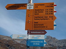
- A main signpost shows the location and altitude on a white field and the destinations with marching times on yellow arrows, with the closest destination on a route at the top and the more distant route destination at the bottom. Several routes can be displayed on a signpost; they are separated from one another by a horizontal line.
- In the case of branches, only the various destinations are listed without marching times.
- At the fork in the road, the hiking trail is marked with a yellow signpost “hiking trail”, a yellow diamond sign or a painted yellow diamond, for mountain hiking trails with white-red-white stripes.
The times indicated for the journey hours are the same for all of Switzerland: the official red sock trot calculates a rate of 4.2 km per hour with surcharges and reductions depending on the incline or decline , not including breaks.
The international hiking trails also receive the logo of the trail (as can be seen in the picture on the right), here for example the logo of the ViaJacobi (Way of St. James).
In addition to the existing signage, yellow direction indicators with green route fields are installed to mark national, regional and local routes. This type of signage has been used on cycle routes for several years.
The aim of the division is to make planning easier for the hikers. A national route takes about a month, regional routes are intended for two to three days, local routes can be mastered in one day. As highlights sections whose attraction factor is greatly improved by a beautiful view or the location on a lake are called.
Themed hiking trails have brown signs
Examples of hiking trails
National hiking trails
National routes (with a single-digit number) cross a large part of Switzerland, and their starting points and destinations are mostly in the border area.
- 1. Via Alpina (formerly "Alpine Pass Route"): Vaduz - Montreux (26 days)
- 2. Trans Swiss Trail : Porrentruy - Mendrisio (32 days)
- 3rd Alpine Panorama Trail (formerly Trans Swiss Trail 2): Rorschach - Geneva (22 days)
- 4. ViaJacobi (part of the Way of St. James ): Constance / Rorschach - Geneva (20 days)
- 5. Jurahöhenweg : Dielsdorf - Nyon (18 days)
- 6. Alpine passes trail : Chur - St-Gingolph
- 7. ViaGottardo : Basel - Gotthard - Chiasso (27 days)
Regional hiking trails
Regional routes lead across several cantons .
Examples (with two-digit) route number:
- 21. Lötschberg route
- 22. Appenzellerland culture trail : Degersheim - Rheineck
- 24. Thurweg : Wildhaus - Wattwil - Bischofszell - Rüdlingen
- 26. Eastern Switzerland Wine Route : Schaffhausen - St. Gallen
- 27. Swiss Tour Monte Rosa : Saas-Fee - Grächen ( Balfrin Höhenweg) - Zermatt ( Europaweg )
- 34. Klettgau-Rhein-Weg : Hallau - Randen - Schaffhausen
- 35. Walserweg Graubünden : San Bernardino - Fire in the Vorarlberg Montafon
- 36. Chemin du vignoble : Martigny - Leuk
- 37. Berner Voralpenweg : Gstaad - Spiez
- 47. Zurich-Zugerland-Panoramaweg : Zurich - Zug
- 55. Via Suvorov : Airolo - Ilanz
- 50. Via Spluga : Thusis - Chiavenna
- 51. Furka -Höhenweg: Oberwald - Andermatt
- 56. Lötschberg panorama trail : Kiental - Fafleralp
- 58. Chemin des bites
- 60. ViaRhenana : Kreuzlingen - Eglisau
- 65. Napfbergland border path : Napf
- 72. Prättigauer Höhenweg : Landquart - Klosters
- 77. ViaGottardo (east arm) : Bargen - Schaffhausen - Bülach - Zurich - Zug - Küssnacht am Rigi
- 79. Thurgauer Panoramaweg : Amriswil - Bischofszell - Wil
- 84. Lake Zurich circular route : Zurich, Manegg - Horgen - Richterswil - Etzel - Pfäffikon SZ - Tuggen - Schmerikon - Rapperswil - Stäfa - Küsnacht ZH - Zurich, Burgwis
- 86th Rhine Falls — Zurich Oberland : Schaffhausen - Wattwil (Ricken)
- 99. Swiss Path : Lake Lucerne
Local hiking trails
Local routes (with a three-digit number) represent an outstanding hiking trail of a place / region.
Examples:
- Beaver path
- St. Gallen Bridge Path
- Whale trail
- Wild hay path
- Schächentaler Höhenweg
- Barefoot path Jakobsbad - Gontenbad
- Joke Trail. This crosses the communities Wolfhalden, Walzenhausen and Heiden .
- Emmetten wildlife observation trail
- Lötschentaler Höhenweg
- Höhenweg
- Ämtlerwäg
- Strada alta in Ticino
International hiking trails
- The European hiking trail E1 crosses Switzerland from Konstanz to Lugano .
- The Via Alpina and the red and green paths of the Via Alpina cross Switzerland or meander along the border with Austria and Italy .
- The Way of St. James (ViaJacobi), which crosses Switzerland from Konstanz / Rorschach to Geneva, is part of the European network of the Way of St. James.
- The Via Francigena runs through Switzerland between Sainte-Croix and Great St. Bernhard .
Historic transit routes
- Via Spluga from Thusis over the Splügenpass to Chiavenna (4 days)
More hiking trails
- Cultural Trail of the Alps : St-Gingolph - Müstair
- Star trails to the Rütli: In 1991, for the 700th anniversary of the Swiss Confederation, ten star trails on existing hiking trails from the state borders to the Rütli were developed. (see example on the picture on the right)
- Swiss Path from Rütli to Brunnen SZ (2 days)
- Strada Alta Leventina ( Ticino ): from Airolo to Biasca (3 days)
- Via Engiadina ( Engadin ): Maloja - Martina (10 days)
- Senda Sursilvana ( Vorderrheintal ): Oberalppass - Chur (6 days)
- Bear trek ( Bernese Oberland ): Meiringen - Gsteig
- Toggenburger Höhenweg : Wildhaus - Wil SG (~ 87 km; 5 days)
history
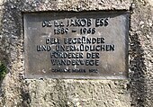
At the beginning of the 20th century, hiking through nature and the mountains also became popular among the Swiss population. With the advent of the car, however, hikers on the streets were increasingly on the defensive. After a school trip on the Klausenpassstrasse, the teacher Johann Jakob Ess (1889–1968) suggested the creation of special hiking routes. However, as the number of these routes increased, so did the variety of their signaling. So in 1933 Ess again founded the Zurich Working Group for Hiking Trails , this time together with Otto Binder, the then secretary of the Pro Juventute Foundation and the Federation of Swiss Youth Hostels . One year later, in 1934, the Swiss Working Group for Hiking Trails (SAW) followed. A uniform signpost for the whole of Switzerland - yellow boards, black lettering - was laid down on the day it was founded.
In 1972, ETH professor Hugo Bachmann gathered various personalities around him to ensure “that people on foot can stay on their way and that they can find their way again: humane, safe paths, without traffic hazard, noise and Exhaust gases, footpaths and hiking trails. So that we can not only drive around the environment as motorists, but also experience it as pedestrians. "
In order to be able to achieve this goal, the hiking trails had to be anchored in the federal constitution. To this end, they launched a popular initiative . The “popular initiative to promote Swiss footpaths and hiking trails” was submitted in 1974 with 123,000 valid signatures. The initiative group was subsequently formed as an association under the name ARF - Working Group on Legal Bases for Footpaths and Hiking Trails (today Foot Traffic Switzerland ). The ARF's popular initiative was rejected by the Federal Council. Thanks to tough lobbying and the great personal commitment of the ARF members, the association managed to get parliament to approve a counterproposal in 1978. The initiative was withdrawn in favor of the counter-proposal.
In the referendum of February 18, 1979, the counter-proposal was approved by the people with 78% yes-votes. All cantons, with the exception of the canton of Valais, accepted the counter-proposal. Based on this, in 1987 the Federal Council put the federal law on footpaths and hiking trails passed by parliament and the ordinance on footpaths and hiking trails into force. Based on this, the Federal Roads Office (FEDRO) issued rules for the uniform signaling of hiking trails in 2005. The existing regulations were largely adopted, but the uniform use of the Astra Frutiger Standard font on the signposts is now also mandatory. However, many signposts are now labeled in Helvetica . After long negotiations, FEDRO stuck to its demand, but set the transition period so that it exceeded the expected natural lifespan of most signs, so that this regulation will not incur any additional costs.
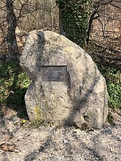
A hiking trail was laid out on the Pfannenstiel from 1972 to 1978 in honor of Jakob Ess . On September 13, 1978, a memorial stone was unveiled by the Meilem municipal council at the Vorderen Pfannenstiel . In 1962, the Medical Faculty of the University of Zurich awarded Jakob Ess an honorary doctorate. Ess came from a farming family in the Thurgau village of Neuwilen . From 1924 until his retirement in 1955 he taught at Meilen Secondary School.
Awards
- 2012 Volunteer Award of the Swiss Non-Profit Society for the innovative corporate volunteering project and exemplary volunteering.
See also
Web links
- Official website of Swiss hiking trails
- Official website for Wanderland Switzerland
- Detailed guides of the national routes
- Hiking in Switzerland on swisshiking.ch
- www.wandersite.ch private website with Swiss hiking tips: day hikes, multi-day tours, winter hikes, trekking tours
- www.gelbezeiten.ch private website with photos of hiking trail signs with time information
- www.travelita.ch private website with photos and reports on hikes in Switzerland
Individual evidence
- ↑ Gönnerinfo magazine «amirando» 2019: Our work in focus. Editor Swiss hiking trails [1]
- ↑ Homepage: SwitzerlandMobility Winter
- ↑ Hiking site: Sternwege zum Rütli , accessed on December 4, 2008
- ↑ Hiking site: Via Engiadina - Engadiner Höhenweg , accessed on December 4, 2008
- ↑ www.wandern.ch Internet presence of Schweizer Wanderwege , formerly SAW
- ^ Federal Constitution of the Swiss Confederation: Article 88 - Footpaths and hiking trails
- ↑ Fussverkehr.ch: History
- ↑ Pfannenstiel.ch


