
Via Spluga

The Via Spluga is a Swiss cultural hiking trail that leads on the historic Alpine transit route from Thusis ( 720 m ) in Switzerland over the Splügen Pass ( 2114 m ) to Chiavenna ( 325 m ) in Italy .
geography
The Via Spluga passes the Schams (Romansh Schons ), Rheinwald and Val San Giacomo valleys over a length of 65 km, follows the Hinterrhein and Liro rivers through the Viamala , Roffla and Cardinello gorges .
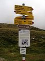
The route is usually covered in four daily stages:
- 1st hiking day: Thusis - Andeer , 15 km, 690 m ascent, 420 m descent, 4 hours (route "Lost Hole") or 6 hours (route east flank Traversina: Via Traversina )
- 2. Hiking day: Andeer - Splügen GR , 15 km, 840 m ascent, 360 m descent, 4 ½ hours
- 3rd hiking day: Splügen - Isola , 17 km, 770 m ascent, 940 m descent, 6 ½ hours
- 4th day of hiking: Isola - Chiavenna, 18 km, 260 m ascent, 1200 m descent, 6 ½ hours
There are overnight accommodations available in the stage towns.
history
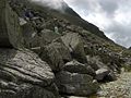
As early as the Bronze Age , a mule track led across the Alps on the Via Spluga , as the rock drawings on the Carschenna , a bypass route for the impassable Viamala Gorge, prove.
The Romans preferred the right-hand access to the Viamala from Sils im Domleschg via Hohen Rätien Castle and the Church of St. Albin opposite the left-hand one from Masein via Rongellen . They conquered the Viamala on the left with several half- galleries carved out of the rock . Around the area of today's road bridge, a wooden bridge directed traffic back to the right bank of the Rhine, via Reischen to Zillis .
In the Middle Ages , long-distance traffic shifted from the Splügen Pass to the Septimer Pass, which was sponsored by the Chur bishop . In 1473, the communities of Thusis, Masein and Cazis, together with other cooperatively organized ports in Viamalabrief , decided to expand their transit route and make it drivable. With the relocation of the transit road from Domleschger to the Heinzenberger valley side on the left bank of the Rhine and the improvement of the Viamala passage, the actual development of the transit and mule route began.
In 1738/39, with the construction of the Wildenbrücken, the most dangerous part of the Viamalastrasse was relocated to the right side of the river (today's cantonal road). On December 6, 1800, 15,000 soldiers of Marshal Macdonald's “Armée des Grisons” (“Army of Graubünden”) crossed the Splügen Pass and the Cardinello Gorge (navigable mule track since 1643, final expansion in 1709) towards Chiavenna.
In 1821–1823 the road that had previously led above Thusis over the Upper Boden to Rongellen was relocated to the eastern slope of the Crapteig through the Lost Hole . With that the whole Viamala was defeated. 1818–1823 the commercial road over the Splügen Pass was created.
With the opening of the Gotthard Railway in 1882, the transit traffic over the Splügen and San Bernardino Passes, which was handled by horse-drawn carriages and carriages, suddenly came to a standstill. The transit of goods over the two passes collapsed from 14,000 tons in 1856 to 1,000 tons in 1883.
Years of crisis and war prevented the implementation of a Splügen and San Bernardino railway project. The emerging gasoline engine led to the first project for a San Bernardino road tunnel in 1927. This was opened to traffic on December 1, 1967 as the first national road Alpine tunnel. Since then, the Splügen Pass has lost its former importance.
The Via Spluga cultural and long-distance hiking trail was opened on July 7, 2001 with a historic parade.
Pictures - from north to south

19th century marble bridge

Historical mule track on the rise
Pass height
After the pass

Montespluga, Italy

Val San Giacomo / Valchiavenna


Places and attractions on Via Spluga
- Thusis ⊙
- Sils im Domleschg ⊙
- Hohen Rätien Castle ⊙
- Carschenna ⊙
- Traversine footbridge ⊙
- “Lost Hole”, the first road in the Graubünden Alps (built 1818–1823, today car-free) ⊙
- Via Mala Gorge ⊙
- Zillis ⊙
- St. Martin Zillis Church ⊙
- Donat ⊙
- Andeer ⊙
- Roffla Gorge ⊙
- Crestawald Fortress Museum ⊙
- Sufers ⊙
- Splügen Castle ⊙
- Splügen ⊙
- Splügen Pass ⊙
- Montespluga ⊙
- Cardinello Gorge ⊙
- Isola ⊙
- Campodolcino ⊙
- Vho ⊙
- Gallivaggio ⊙
- San Giacomo Filippo ⊙
- Chiavenna ⊙
Web links
- Official website of Via Spluga
- Travel information Via Spluga
- Traversine footbridge
- Roffla Gorge
- Crestawald Fortress Museum
Individual evidence
- ↑ Wanderland 50 Via Spluga
- ↑ Lost Hole on ETHorama