
Hinterrhein
| Hinterrhein | ||
 Alpine, Front and Rear Rhine |
||
| Data | ||
| Water code | CH : 283 | |
| location | Switzerland | |
| River system | Rhine | |
| Drain over | Rhine → North Sea | |
| source |
Rheinwaldhorn , Güferhorn , Rheinquellhorn 46 ° 29 ′ 55 ″ N , 9 ° 3 ′ 45 ″ E |
|
| Source height | approx. 2400 m above sea level M. | |
| confluence | at Reichenau with the Vorderrhein to the Rhine Coordinates: 46 ° 49 '24 " N , 9 ° 24' 28" E ; CH1903: 750 244 / 187 683 46 ° 49 '24 " N , 9 ° 24' 28" O |
|
| Mouth height | 584 m above sea level M. | |
| Height difference | approx. 1816 m | |
| Bottom slope | approx. 28 ‰ | |
| length | 64.9 km (with Dischmabach 72 km) | |
| Catchment area | 1698 km² | |
| Drain at the mouth |
MQ 1961-1980 |
59.6 m³ / s |
| Discharge at the Fürstenau A Eo gauge : 1577 km² Location: 13 km above the mouth |
NNQ (1979) MNQ 1974–2016 MQ 1974–2016 Mq 1974–2016 MHQ 1974–2016 HHQ (1981) |
2.64 m³ / s 23.3 m³ / s 39.5 m³ / s 25 l / (s km²) 60.5 m³ / s 713 m³ / s |
 The Hinterrhein in Splügen |
||

| ||
Source and mouth of the Hinterrhein
|
The Hinterrhein , in the Rhaeto-Romanic idiom Sutsilvan Rein Posteriur , is one of the source rivers of the Rhine and is located in the Swiss canton of Graubünden . It rises on the slopes of the Rheinwaldhorn , Güferhorn and Rheinquellhorn and unites near Reichenau with the Vorderrhein to form the river now known as the Rhine.
geography
Course and valley landscape
The valley of the Hinterrhein consists of three terrain chambers from top to bottom: the Rheinwald with Splügen as the largest village, the Schams with Andeer and the Domleschg / Heinzenberg region with Thusis . In between are the once feared traffic obstacles of the Roffla Gorge above the Schams and the Viamala below.
The origin of the Hinterrhein can be reached in around four hours on foot from the village of Hinterrhein via the Zapporthütte SAC ( 2276 m ). The uppermost part of the valley is connected to Ticino via the San Bernardino Pass ; The historic Splügen Pass leads from Splügen to Chiavenna in the Italian province of Sondrio . From Thusis the road branches off to Davos , respectively to the Julier Pass and the Albula Pass .
The Hinterrhein is at 64 kilometers and a maximum, measured over the Dischmabach as the longest flow path, 72 kilometers in length slightly shorter than the Vorderrhein with, measured over the Rein da Medel , about 76 kilometers. However, with a water flow of 59.6 m³ / s, it is larger than the Vorderrhein, which carries 53.8 m³ / s. On the question of the source of the Rhine, see Rheinquelle .
The Albula is the most important tributary of the Hinterrhein. With natural runoff, which is currently not present in both rivers due to the use of hydropower, the Albula at the confluence in Fürstenau is even larger with an average of 29.1 m³ / s than the Hinterrhein, which has 27.3 m³ / s of water there.
Tributaries
- Usser Teiltobel Bach (left)
- Höhbergtobel (left)
- Weissbach (left)
- Grattobel (right)
- Brunstbach (left)
- Schgräjendbach (right)
- Maseggbach (right)
- Plattenbach (left)
- Räppierbach (left)
- Kappelbach (right)
- Altnerschbach (left)
- Areuabach (right)
- Hoflibach (left)
- Chratzlibach (right)
- Függschtobelbach (left)
- Tambobach (right)
- Hüscherabach (right)
- Stutzbach (left)
- Strahlentobelbach (right)
- Wissbach (left)
- Steilerbach (left)
- Töbeli (left)
- Surettabach (right)
- Lungbach (left)
- Averser Rhine ( Ragn da Ferrera , second largest tributary, right)
- Ual da Pignia (right)
- Fundogn (left)
- Ual da Suden (left)
- Plattera (left)
- Ual da Reischen (right)
- Nolla (left)
- Albula ( Alvra , largest tributary, right)
- Scharanser Tobel (right)
- Caznerbach (left)
- Almenser Tobel (right)
- Tomilser Bach (right)
- Val da Treps (right)
gallery

View from the Rheinwaldhorn 3402 m to the east, "Ursprung" with the young Hinterrhein and further towards the Hinterrheintal

Hinterrhein village (Graubünden) with Marschol, Rheinquell and Höhberghorn. The San Bernardino Pass can be seen in the upper left part
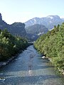
The Hinterrhein between Thusis and Sils in Domleschg with the Hohe Rätien

Hinterrhein near Rhäzüns
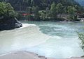
Confluence of the Hinterrhein (right) and Vorderrhein (left) near Reichenau

_mit_Marschol-,_Rheinquell-_und_H%C3%B6hberghorn.jpg)


Web links
- Hinterrhein on the ETHorama platform
- River map for the fishing statistics (PDF file; 2.18 MB)
Individual evidence
- ↑ a b Geoserver of the Swiss Federal Administration ( information )
- ↑ Federal Office of Topography : Topographical river analyzes in the headwaters of the Rhine ( memento of the original from April 2, 2015 in the Internet Archive ) Info: The archive link was inserted automatically and has not yet been checked. Please check the original and archive link according to the instructions and then remove this notice. (PDF; 2.8 MB), Bern 2011
- ↑ Topographical catchment areas of Swiss waters: area outlets. Retrieved May 30, 2019 .
- ↑ a b Hydrological Atlas of Switzerland of the Federal Office for the Environment FOEN, Table_54
- ↑ Fürstenau measuring station 1974–2016 (PDF) Federal Office for the Environment FOEN
- ↑ Hiking Switzerland: Via Spluga, the cultural and historical hiking trail
- ↑ The flow paths of the Albula-Landwasser-System belonging to the Hinterrhein system are longer and richer in water than the Hinterrhein itself.
Rivers with a total length of more than 30 km:
Aare |
Albula |
Allaine |
Old Rhine |
Arbogne |
Areuse |
Swiss stone pine |
Birs |
Brenno |
Broye |
Calancasca |
Doubs |
Drance de Bagnes |
Thinning |
Emme |
Engelberger Aa |
Ergolz |
Glâne |
Smooth |
Glenner (Glogn) |
Hinterrhein |
Inn (En) |
Julia (Gelgia) |
Kander |
Little Emme |
Landquart |
Land water |
Langete |
Limmat |
Linth |
Lorze |
Maggia |
Mentue |
Moësa |
Muota |
Murg |
Necker |
Orbe |
Petite Glâne |
Plessur |
Rabiusa |
Reuss |
Rhine |
Rhone |
Saane |
Schüss (Suze) |
Seez |
Scythe |
Sihl |
Simme |
Sitter |
Sorne |
Suhre |
Talent |
Tamina |
Ticino (Ticino) |
Thur |
Töss |
Venoge |
Verzasca |
Vispa |
Vorderrhein |
Wigger |
Wyna