
Limmat


|
Tributaries and hydraulic structures
|
The Limmat (Zurich German Limet [lɪmət] , older Limig [lɪmɪg] , in the Aargau lower reaches still today Limmig [lɪmːɪg] ) is a river in Switzerland . It forms the 36-kilometer-long lower section of the Linth- Limmat river system that begins near Zurich . It flows into the Aare and is its second largest tributary .
River course
The upper reaches of the river rises as Linth in the canton of Glarus in the Tödi massif . Since the river was corrected in the Lint plain in the 19th century , it has flowed into Lake Walen and from there through the Lint Canal into Lake Zurich , of which it is the main tributary. The Linth Canal forms the border between the cantons of Glarus, St. Gallen and Schwyz .
The river takes the name Limmat from Zurich, where it leaves Lake Zurich. It flows then through the Limmat leaves in Oetwil am the Canton of Zurich and crosses at Baden a Jura transverse valley . In the canton of Aargau , the Limmat flows into the Aare in the so-called “ Moated Castle of Switzerland ” near Gibstorf and Untersiggenthal opposite Lauffohr .
The surface of the water at the point where the Limmat leaves Lake Zurich has changed significantly over time. Up until the Middle Ages, to the south of the old town of Zurich, as far as the area of today's Münsterhof, there were wet bank zones and bays of the lake that were only gradually covered by debris from the Sihl and artificial embankments. In the 19th century, the landing stages for ships were still within the area previously protected by the city walls. With the construction of the quay facilities , the city gained wide open spaces at the newly designed lower lake basin with Bürkliplatz , and the beginning of the course of the Limmat has since been at the quay bridge, which was built between 1882 and 1884 . Because of this bridge, the seagoing ships can no longer enter the Limmatraum as they used to and therefore anchor at the new ship landing in front of Bürkliplatz.
After the Limmat has left Lake Zurich, it flows through the historic center of Zurich between the Limmatquai on the right and the Stadthausquai, the Schipfe and the Bahnhofquai on the left. After the Quaibrücke, the Münsterbrücke , the Rathausbrücke , the Rudolf-Brun-Brücke , the Mühlesteg , the Bahnhofbrücke and the Walchebrücke cross the river in the area of the old town . In a wide curve, the course of the river below the Walchebrücke changes from north to more west. At Platzspitz , the Limmat takes on the Sihl , the largest tributary. This is the first time that the Limmat's hydropower is used, which, with a total gradient of 78 meters, provides a very high energy potential . Some of the water falls over the Drahtschmidli weir , which is used to regulate Lake Zurich, the rest is fed to the Letten power station . The Werdinsel was created in Zurich-Altstetten through the construction of an upper water canal for the Höngg power plant .
The river forms several loops in the broad Limmat valley west of Zurich. In Dietikon there is another power plant. Below that are the Dietiker Altllauf , remnants of the primeval meadow landscape , which were placed under nature protection in 1930. After crossing the border with the canton of Aargau, the Limmattal narrows between Heitersberg in the south and Altberg in the north. From Würenlos the river to the narrow and seven kilometer long Wettingen reservoir is dammed. After the Wettingen power plant , the river lies in a deep cut in the moraine landscape and passes the Klus between the Heitersberg and the Lägern near Baden . Below the rapids at the bathing area of Baden, the valley widens again a little, the river crosses the floodplain between the villages, which are located on gravel terraces. Below Baden and Turgi are more old power plants: the plant Oederlin in Ennetbaden, the power plant Kappelerhof , the boat mill in Untersiggenthal, the power plant Turgi and just before the confluence with the Aare to the left of the KW Gebenstorf and right the power plant Stroppel .
The largest tributaries of the Limmat are the Sihl and the Reppisch , which flow into Dietikon. The Sihl, which at times also had estuary arms leading directly into Lake Zurich, dammed the Limmat in Zurich in the 1st millennium BC with rubble brought in. As a result, the level of Lake Zurich rose significantly, and the discharge of the Limmat shifted to the north. By removing the debris at the mouth of the Sihl in Roman times , the water level of Lake Zurich fell sharply. In late and post-Roman times, no more rubble was removed, the Limmat was dammed again, and the lake level rose again for several centuries. In the course of the early Middle Ages , the Sihl was regulated again, so that at the latest since the year 853, when the Fraumünster was founded, the lake level was at today's level.
origin of the name
The earliest evidence of the river name is ad fluvium Lindimacum (771), de ripa Lindimagi fluminis (820?), Iuxta fluvium Lindemaci (before 840) and cis Lindimacum (870). Forms on -agt are attested from the 15th and 16th centuries, those on -at only after 1500. The dialectal sound Lim (m) ig is closer to the original than the written Limmat .
There are several interpretations:
- Joachim Vadian and John Stumpf , scholars of humanism suggested before, Lindma (g) t as a composition of Linth and Maag to interpret, so the two rivers then converging in the Linthebene, with "Maag" a name for the Walen leaving Seez be should. Recently, this interpretation has also been shared by German names researchers Bruno Boesch (1963) and Albrecht Greule (1973). Whether the outflow from the Walensee was actually called “Maag” is, however, controversial in name research. Incidentally, such a double name, a Dvandva compound (“Linth and Maag”), would be “highly conspicuous” ( Albrecht Greule ) for a water body name .
- Johann Ulrich Hubschmied , who liked to see mythological beings in river names, traced the name back in 1930 to a Gallic * Lento-magos , which means "great dragon".
- Felix Stähelin rejected Hubschmied's interpretation in 1935, especially since “neither * lento-s ‹ bendable, worm ›nor * mago-s ‹gross› are really attested for the Gallic language”, and brought, Adolf Bacmeister , Michael Richard Buck , Rudolf Much and Ernest Following Muret , the meaning , which also goes back to the Celtic , «level by the water, marshy level, Seefeld», composed of * lindo «water» and * magos «level», comes back into play. The river would have taken on the name that originally referred to the area around the river. This interpretation is supported by two inscriptions from Roman times found in 2013 in the Seewiese near Kempraten , on which the name Lindomagus is recorded. However, this Lindomagus was located near today's Rapperswil and thus in the area of the upper Lake Zurich and not the current Limmat River.
The other terms Aa and See, which are occasionally found in late medieval and early modern sources for the part of the Limmat located within the city of Zurich, are (semi) appellative and not to be understood as names; Aa or Ache is an old word for «stream, river».
traffic
Even before the turn of the century, the Limmat served as a waterway for transporting goods. After the Roman conquest around 15 BC. The Limmat was located on the border of the Roman provinces Raetia ( Raetia ) and Germania superior (Upper Germany). At today's Weinplatz in vicus Turicum (Zurich), goods from the traffic of goods were reloaded via the Alpine route, from Lake Walen via Centum Prata (Kempraten) on Lake Zurich, from sea to river vessels for transport on the Limmat.
Today, the Limmat is only navigable from Lake Zurich to Platzspitz and the first weir that regulates the amount of runoff from the lake. Over long distances, however, it can only be used by Limmatschifffahrt passenger boats. In the past, however, it served as a public waterway up to the estuary, and between Zurich and Baden also for the “ Badenfahrten ”. Traders in particular began their journeys in Biäschen - small boats - on the Linth and Walensee and sold their goods in the confluence of the Rhine. The “ millet trips” that the people of Zurich have made several times since 1456 via the Limmat, Aare and Rhine to Strasbourg are legendary . Since the construction of the power plants, it has no longer been possible to travel by transport ships because the river in Zurich - am Letten and in Höngg - Dietikon, Wettingen, Baden and Turgi is blocked for regulation and energy generation through dams and weirs. Only small boats can cross the obstacles using the boat ramps.
Today the Limmat shipping is part of the local public transport of the city of Zurich. Limmat ships operate from April to October in the upper part of the Limmat and the lake basin. The stations of the Limmat ships are seen upstream: State Museum at the main train station , Limmatquai , Storchen and Bürkliplatz . The route runs right through the old town under six bridges and a footbridge. The Limmat lines belong to the tariff association of the Zürcher Verkehrsverbund .
In Zurich there are boat stands on the Limmat, which are managed by the Zurich port administration. Private boats are not allowed to drive on the section from Münsterbrücke to Lettenwehr.
The Zurich – Dietikon section is often used by rubber dinghies in the summer months ; A popular entry point is the staircase in the Wipkingerpark. The weir is not navigable Höngg and must portage be. Exit opportunities are indicated on the left bank.
From Zurich main station to the bridge at Stilli below the confluence with the Aare, marked hiking trails follow the river, mostly right on the banks of the Limmat (hiking time: around 9.5 hours). From Höngg to Schönenwerd, the riverside paths are also designed as “ barrier-free paths ”. In the Wettingen-Baden area, the official hiking trails coincide with the culture trail , below Baden with the industrial culture trail Limmat-Wasserschloss , which provides information on historical hydraulic engineering systems and other technical and historical objects near the river. At Untersiggenthal , the Limmat Gorge has such steep bank areas that the hiking trail has to switch to the gravel terrace; In addition, he leads around the factory premises at the " Schiffmühle ".
bridges
From Lake Zurich to the Aare, the Limmat is crossed by over 80 bridges. The structures that exist today date from the 19th and 20th centuries, and some of them are among the region's most important technological and historical monuments. The oldest still existing river bridges are the wooden bridge of Baden near the Landvogteischloss and the wooden bridge Wettingen-Neuenhof , which were built as replacement structures for the older crossings destroyed in the coalition wars. The oldest existing Limmat bridges in Zurich are the Münsterbrücke, the Letten viaduct and the Aussersihl viaduct from the 19th century. In 1859 the Limmat Bridge on the NOB line from Turgi to Koblenz was put into operation.
Military history
For centuries, in addition to a few ferries (such as at Fahr Monastery , Oetwil and below Wettingen Monastery ), only the two bridges in Zurich and Baden crossed the river, which was therefore of great military importance as a traffic obstacle.
The course of the Limmat therefore shaped several historical events: At the time of the Regensberg feud , Zurich destroyed the city of Glanzenberg, which was built by the barons of Regensberg on the riverbank . With the conquest of the Habsburg city of Baden by the Confederates in 1415 and the siege of Baden in the Second Villmerger War in 1712, the situation on the river made it difficult for the attackers to take action. In the First Battle of Zurich , the Limmat separated the opposing armies, and in the Second Battle of Zurich , the surprising crossing of the river by the French army with boats and on a pontoon bridge was a tactical measure that was decisive for the course of the war.
In the Second World War , the Swiss Army finally built the so-called Limmatstellung from Zurich to Turgi , some of the fortifications of which are still preserved today.
Flood
The mean annual flood of the Limmat at the measuring point Limmat - Baden, Limmatpromenade (2243) is 368.58 m³ / s. The highest annual peak ever measured was registered in 1999 and was 660 m³ / s.
| Annuality (years) | 2 | 5 | 20th | 30th | 50 | 100 |
|---|---|---|---|---|---|---|
| Discharge (m³ / s) | 356 | 429 | 476 | 547 | 579 | 623 |
| Note to HQN: the number corresponding to the high water flow (HQ = H ochwasser q uantität) in m³ / s, which - repeated with the specified return period (n = number of years) - the average. | ||||||
swim
Bathing in the Limmat is prohibited in the Zurich city area from the Quaibrücke to the Letten Canal. There are four public municipal bathing facilities available: the Frauenbad on Stadthausquai a little below the Quaibrücke, the Upper and Lower Letten river baths on the Letten Canal, and the Au-Höngg outdoor pool on the Werdinsel with swimming in the Limmat Canal .
The Limmat Swimming has been taking place in downtown Zurich since 1945 as an annual popular sports event. The two-kilometer swim begins at the Frauenbad and ends in the Upper Letten river pool.
The ten meter high Kornhausbrücke near Letten is used for cliff jumping .
Naming
- Limmat was the name of the first locomotive in Switzerland. It operated from 1847 for the Swiss Northern Railway / Spanish Brötli Railway between Zurich and Baden.
- Limmat is the name of a large motor ship in the Lake Zurich fleet .
- A column with articles from Zurich in the satirical magazine Nebelspalter was called Limmatspritzer .
- Limmat Verlag in Zurich was founded in 1975.
photos

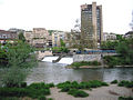
The young Limmat in Zurich at the second bridge
Confluence with the Sihl in Zurich

Limmatraum in Zurich around 1910 with the upper and lower Mühlesteg and the women's bathing establishment in the middle of the river

Confluence of the Aare (left) and Limmat (right)


Web links
- Martin Illi: Limmat. In: Historical Lexicon of Switzerland .
Individual evidence
- ↑ a b c Geoserver of the Swiss Federal Administration ( information )
- ↑ a b Evaluations of the water network. (XLSX) FOEN , December 2013, accessed on August 9, 2017 (listing of Swiss rivers> 30km).
- ↑ Modeled mean annual discharge. In: Topographical catchment areas of Swiss waters: sub-catchment areas 2 km². Retrieved September 8, 2017 .
- ↑ Baden measuring station, Limmatpromenade 2016 (PDF) Federal Office for the Environment FOEN
- ↑ Dölf Wild: Zurich City under water - interaction between nature and people in Zurich's early days . In: City of Zurich, Office for Urban Development (Ed.): Archeology and Monument Preservation. Report 2006–2008 . gta Verlag, Zurich 2008, ISBN 978-3-85676-238-4 , p. 21–23 ( online (PDF 507 kB)).
- ↑ StiASG , Urk. III 307. Online at e-chartae , accessed on June 19, 2020 (see third line)
- ↑ a b c d Albrecht Greule: Pre- and early Germanic river names on the Upper Rhine. A contribution to the naming of waters in Alsace, northern Switzerland and southern Baden. Winter, Heidelberg 1973, pp. 129-132.
- ^ Albrecht Greule: German water names book. Etymology of the water body names and the associated area, settlement and field names. De Gruyter, Berlin / Boston 2014, p. 315 f .; here, however, he also considers Felix Staehelin's interpretation to be possible.
- ↑ The name Maag is first attested to in Vadian (16th century), which is very late for a river name. Hans Jacob Leu actually names the discharge in his General Helvetic or Swiss Lexicon (XIX. Theil, Zurich 1764, p. 98, article Wallenstadter- or Wallen-See ) like the upper course “ Seez ”.
- ↑ Jakob Früh: Geography of Switzerland. Volume I. Fehr, St. Gallen 1930, p. 406; again in the Small Bund 1931, No. 48, p. 381.
- ^ Felix Stähelin: Pre-Roman Switzerland in the light of historical evidence and linguistic facts. In: Zeitschrift für Schweizerische Geschichte 15, 1935, pp. 337–368, here p. 352.
- ^ Albrecht Greule: German water names book. Etymology of the water body names and the associated area, settlement and field names. De Gruyter, Berlin / Boston 2014, p. 315 f., Also takes up this interpretation and thinks about whether it was originally a name of the area with the meaning of 'Linth level'. In his article Limmat in the Deutscher Gewässernamenbuch he still primarily assumes a “copulative composition of the river names Linth and Maag”.
- ^ The legal sources of the canton of St. Gallen. Editorial tradition, new project, practical application. 153. Neujahrsblatt, 2013. Edited by the Historical Association of the Canton of St. Gallens. St. Gallen 2013, p. 86.
- ↑ Martin Illi: Limmat. In: Historical Lexicon of Switzerland .
- ↑ Information on small shipping on the Limmat on the website of the Canton of Aargau, accessed on October 11, 2018.
- ↑ Order of the Directorate of the Police of the Canton of Zurich (14/1981)
- ↑ Eberle, Iwona. Rubber boat guide Switzerland. Thun: Werd Verlag, 2015. ISBN 978-3-85932-742-9
- ↑ Order of the Directorate of the Police of the Canton of Zurich (19/1981)
- ↑ Limmat-Uferweg on schweizmobil.ch, accessed on October 11, 2018
- ↑ Flood probabilities (annual flood), Limmat - Baden, Limmatpromenade. (PDF) Federal Office for the Environment FOEN, Hydrology Department, accessed on January 29, 2014 .
- ↑ Measuring point: Limmat - Baden, Limmatpromenade (2243), on FOEN hydrodata
- ↑ General Police Ordinance of the City of Zurich (APV) .
Rivers with a total length of more than 30 km:
Aare |
Albula |
Allaine |
Old Rhine |
Arbogne |
Areuse |
Swiss stone pine |
Birs |
Brenno |
Broye |
Calancasca |
Doubs |
Drance de Bagnes |
Thinning |
Emme |
Engelberger Aa |
Ergolz |
Glâne |
Smooth |
Glenner (Glogn) |
Hinterrhein |
Inn (En) |
Julia (Gelgia) |
Kander |
Little Emme |
Landquart |
Land water |
Langete |
Limmat |
Linth |
Lorze |
Maggia |
Mentue |
Moësa |
Muota |
Murg |
Necker |
Orbe |
Petite Glâne |
Plessur |
Rabiusa |
Reuss |
Rhine |
Rhone |
Saane |
Schüss (Suze) |
Seez |
Scythe |
Sihl |
Simme |
Sitter |
Sorne |
Suhre |
Talent |
Tamina |
Ticino (Ticino) |
Thur |
Töss |
Venoge |
Verzasca |
Vispa |
Vorderrhein |
Wigger |
Wyna