
Spreitenbach
| Spreitenbach | |
|---|---|
 |
|
| State : |
|
| Canton : |
|
| District : | to bathe |
| BFS no. : | 4040 |
| Postal code : | 8957 |
| UN / LOCODE : | CH SPB |
| Coordinates : | 669 989 / 252336 |
| Height : | 417 m above sea level M. |
| Height range : | 380–713 m above sea level M. |
| Area : | 8.60 km² |
| Residents: | 12,087 (December 31, 2019) |
| Population density : | 1405 inhabitants per km² |
|
Proportion of foreigners : (residents without citizenship ) |
50.4% (December 31, 2019) |
| Website: | www.spreitenbach.ch |
 View from the Käferberg |
|
| Location of the municipality | |
  |
|
Spreitenbach ( Swiss German : ˈʃpræːitəˌbɑχ ) is a municipality in the Swiss canton of Aargau . It belongs to the Baden district and is located southeast of the district capital in the central Limmat Valley , right on the border with the canton of Zurich .
geography
The village is halfway between Baden and Zurich on the south side of the Limmat . The settlement area extends over the wide plain between the foot of the Heitersberg and the river bank. The old village center of Spreitenbach, through which the Dorfbach flows, is located on the southern edge of the settlement and has largely retained its original character. To the north of this is the modern part with spacious residential areas, high-rise buildings, commercial zones, sports facilities and shopping centers. In the far north, separated from the rest of the settlement by the motorway and the railway line, in a loop of the Limmat is the extensive industrial zone Neuhard. The Kessel-Spreitenbach hydropower plant was built on the river in 1867 to operate a spinning mill. Since the Wettingen power plant was built , the Limmat near Spreitenbach has been in its storage area. The river bank in the municipality belongs partly to the area of the protected floodplain landscape on the Limmat. The Limmattal marshalling yard extends across the eastern part of the plain . The AEW operates the Hardrütenen substation near the Limmat .
The village stream takes in several streams in the old village center, which arise in the steep forest area on the north slope of the Heitersberg; including the Wilebach, the Ägelseebach and the Tobelächerbach. The Chlosterweiher (or Franzosenweiher ) is located on Wilebach, in the immediate vicinity of the municipal border with Dietikon . The Altes Bad biotope is made up of a pond and a wetland with a wealth of plants. The municipality has designated this area with the adjacent forest as a nature reserve. The pond got its name because the Napoleonic troops camped there before they crossed the Limmat at Fahr Monastery . The hamlet of the same name is located around two kilometers west of the village on the high plateau of the Heitersberg in a large clearing.
The area of the municipality is 860 hectares , of which 306 hectares are forested and 338 hectares are built over. The highest point is the Berg forest area near the Heitersberg pass at 672 m above sea level. M. , the deepest point is 385 m above sea level. M. on the Limmat. Neighboring communities are Würenlos in the north, Oetwil an der Limmat in the northeast, Dietikon in the east, Bergdietikon and Bellikon in the south, Remetschwil in the west and Killwangen in the northwest.
history
Various archaeological finds indicate settlement during the Mesolithic and Neolithic . Spreitinbach was first mentioned in a document in 1124. The place name comes from the Old High German (ze demo) spreiten bahhe and means "by the brook that is spreading". In addition to numerous monasteries, the knights of Schönenwerd (near Dietikon ) were particularly important landowners. Between 1274 and 1287, they had to sell all their goods to the Wettingen monastery , which became the most important landlord of the village. The Habsburgs were sovereigns and holders of blood jurisdiction .
In 1415 the confederates conquered Aargau. Spreitenbach was now part of the Dietikon office in the county of Baden , a common rule . In 1541 the Wettingen monastery acquired lower jurisdiction from the Effinger family . In 1670 and 1785, village fires destroyed numerous houses. In March 1798 the French took Switzerland and proclaimed the Helvetic Republic . Spreitenbach was initially a municipality in the short-lived canton of Baden , since 1803 it has belonged to the canton of Aargau.


On August 9, 1847, Switzerland's first railway line, the Swiss Northern Railway between Zurich and Baden , went into operation. The Spreitenbachers advocated a route far away from the village, because they feared negative effects on agriculture. For this reason, the next train station is still in neighboring Killwangen , although this municipality has around seven times fewer inhabitants. The industrialization began relatively late, in 1862 with the opening of a cotton mill.
Until the mid-1950s, Spreitenbach was a farming village with a few small businesses and a glider airfield . But then a building boom set in that is second to none. Since cohabitation was prohibited in the canton of Zurich at the time , the demand for living space in the canton of Aargau and in particular in Spreitenbach increased significantly. The general housing shortage due to the strong population growth intensified this development. «Neu-Spreitenbach» was designed on the drawing board and then partially implemented into reality. A satellite city was planned . High-rise estates and extensive commercial and industrial zones were built. In the mid-1960s, the planners assumed a population of 35,000 and 20,000 jobs in the final stage. Due to the oil crisis and the subsequent economic downturn in the 1970s, the visions could only partially be implemented. In 1981 a new building zone plan came into effect, which resulted in less dense settlement and a move away from high-rise construction.
In 1970, the first shopping center in Switzerland in the style of an American shopping mall was opened, the "Shopping Center Spreitenbach". In addition, the first high-rise buildings were built. In 1974 a second, even larger shopping center followed, the “Tivoli”. The two shopping centers have merged since 2001 and have appeared as Shoppi Tivoli since 2010 . Spreitenbach has long been regarded as a prime example of the unchecked urban sprawl of the Swiss Plateau in the 20th century. Since 1960 the population of the municipality has increased more than sixfold. Hardly any other municipality in the canton of Aargau has seen such great growth.


Attractions
The following buildings are protected by homeland or cultural property :
- Catholic Church of Cosmas and Damian , new Roman Catholic Church
- Old parity church , Evangelical Reformed village church
- Hasel church center , with the evangelical-reformed parish hall
- Former Catholic rectory, Ratzengasse 10
- former catholic school house, Ratzengasse 16
- 16th century granary, now a local museum
As a special feature, the old parity, now Reformed church still carries a cross on the church tower, while the new Roman Catholic church carries a rooster on the church tower. The Bruno Weber sculpture park by the sculptor Bruno Weber is located in the municipality of Spreitenbach, the main entrance on the border with Dietikon. Therefore, the description of the approach and access can usually be found under Dietikon and not under Spreitenbach.
photos

Parish hall

village street

Old rectory

Spitzwiesenstrasse
Schoolhouse Seefeld

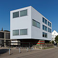
Schoolhouse Boostock


Boostock gym

Country road
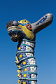
Spinning top sculpture by Bruno Weber
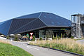
Environmental arena

Reformed Cross Church Haslen

Block of flats on Poststrasse


coat of arms
The blazon of the municipal coat of arms reads: "Square of blue with a crowned yellow leopard head and of red with a six-pointed white star." On the coat of arms of the municipality seal from 1872 a linden tree and a fir tree were depicted. The coat of arms used today goes back to a recommendation by the local chronicle and was introduced after 1930. It is shown on a map of the canton of Zurich from 1667. The leopard's head refers to the Lords of Schönenwerd, the star to the Wettingen Monastery, the former court lord.
population
The population developed as follows:
| year | 1487 | 1780 | 1850 | 1900 | 1930 | 1950 | 1960 | 1970 | 1980 | 1990 | 2000 | 2010 |
| Residents | approx. 90 | 383 | 669 | 913 | 1064 | 1173 | 1964 | 5978 | 7198 | 8315 | 9127 | 10,927 |
On December 31, 2019, 12,087 people lived in Spreitenbach, the proportion of foreigners was 50.4%, making it by far the highest in the canton of Aargau (more than double the cantonal average). In the 2015 census, 31.2% described themselves as Roman Catholic and 10.7% as Reformed ; 58.1% were non-denominational or of other faiths. In the 2000 census, 72.1% stated German as their main language, 7.0% Italian , 6.1% Serbo-Croatian , 4.8% Albanian , 2.3% Turkish , 1.2% Spanish and 1.1% each. French and Portuguese .
Politics and law
The assembly of those entitled to vote, the municipal assembly , exercises legislative power. The executing authority is the five-member municipal council . He is elected by the people in the majority procedure, his term of office is four years. The parish council leads and represents the parish. To this end, it implements the resolutions of the municipal assembly and the tasks assigned to it by the canton. The Baden District Court is responsible for litigation in the first instance . Spreitenbach belongs to the Friedensrichterkreis IV (Wettingen).
In the 2019 Swiss parliamentary elections, the share of the vote in Spreitenbach was: SVP 35.3%, SP 19.9%, CVP 10.6%, FDP 10.3%, glp 8.1%, Greens 7.5%, BDP 2, 6%, EVP 2.5%, team 65+ 1.9%.
Spreitenbach introduced the residents' council in 1974 , but abolished it in 1985 and returned to the "proper community organization" with community assembly.
A partnership has existed between Spreitenbach and the Italian city of Bra in the province of Cuneo since 1988 .
economy


Due to its excellent traffic situation in the west of the agglomeration of Zurich, Spreitenbach is an important business location. According to the corporate structure statistics (STATENT) collected in 2015, there are around 8,200 jobs, of which 1% in agriculture, 17% in industry and 82% in the service sector.
Numerous well-known companies have settled here. The most famous are doubts (potato chips), Bridgestone (tires), Johnson & Johnson (pharmaceuticals and cosmetics), Nestlé (food), Miele (household appliances), Chiquita (Banana producer) and the Migros belonging Magazine zum Globus (Retail) Limmatdruck Zeiler (Media and packaging) and ITRIS (medical technology and IT services). The large shopping center Shoppi Tivoli and the furniture store IKEA (whose branch opened in 1973 was the first outside Scandinavia) form the backbone of the service industry.
In 2008 the municipality of Spreitenbach was awarded the “ energiestadt ” label . In 2012 the Umwelt Arena was opened, an exhibition and event building for environmental technology.
traffic
The community is located on the busy main road 3 from Zurich to Baden . The Dietikon connection to the A1 motorway is two kilometers east of the village. In 2008, Spreitenbach was given its own half-connection, but it is only accessible from and in the direction of Bern . The railway line runs through Spreitenbach through the Limmattal , which branches off at Killwangen into the lines to Baden and Basel or to Aarau and Bern (with the Heitersberg tunnel ). The largest marshalling yard in the country, the Limmattal marshalling yard, was built near Spreitenbach and the neighboring town of Dietikon around 1978 (commissioning of the last expansion stage) .
Spreitenbach is accessed by several bus routes. Lines 2 and 4 of the RVBW run via Killwangen, Neuenhof to Baden train station (line 4 via Wettingen ). Line 10 connects the Härdli industrial area from the Killwangen-Spreitenbach train station . A Limmat Bus line runs from Killwangen via Spreitenbach and Dietikon to Schlieren . There is a connection to the Zurich S-Bahn at the Killwangen-Spreitenbach and Dietikon stations . On weekends there is a night S-Bahn ( Winterthur - Zurich HB - Baden - Brugg - Lenzburg - Aarau ) and a night bus from Baden to Dietikon. From 2022, Spreitenbach is also to be opened up by the Limmattalbahn between the Zurich Altstetten and Killwangen-Spreitenbach stations.
education
In Spreitenbach there are nine kindergartens and eight schoolhouses in which all levels of compulsory elementary school are taught ( primary school , secondary school , secondary school and district school ).
The closest grammar schools are the Baden Cantonal School and the Wettingen Cantonal School .
literature
- Andreas Steigmeier : Spreitenbach. In: Historical Lexicon of Switzerland .
- Peter Hoegger: The art monuments of the canton of Aargau . Ed .: Society for Swiss Art History . Volume VII: District of Baden II. Birkhäuser Verlag, Basel 1995, ISBN 3-909164-44-7 , p. 111-131 .
Web links
Individual evidence
- ↑ Cantonal population statistics 2019. Department of Finance and Resources, Statistics Aargau, March 30, 2020, accessed on April 2, 2019 .
- ↑ Cantonal population statistics 2019. Department of Finance and Resources, Statistics Aargau, March 30, 2020, accessed on April 2, 2019 .
- ↑ a b Beat Zehnder: The community names of the canton of Aargau . In: Historical Society of the Canton of Aargau (Ed.): Argovia . tape 100 . Verlag Sauerländer, Aarau 1991, ISBN 3-7941-3122-3 , p. 402-404 .
- ↑ The Limmat
- ^ National map of Switzerland, sheet 1090, Swisstopo.
- ↑ Website about the Limmattal marshalling yard
- ↑ Standard area statistics - municipalities according to 4 main areas. Federal Statistical Office , November 26, 2018, accessed on June 4, 2019 .
- ↑ Local museum
- ^ Joseph Galliker, Marcel Giger: Municipal coat of arms of the Canton of Aargau . Lehrmittelverlag des Kantons Aargau, book 2004, ISBN 3-906738-07-8 , p. 279 .
- ↑ Population development in the municipalities of the Canton of Aargau since 1850. (Excel) In: Eidg. Volkszählung 2000. Statistics Aargau, 2001, archived from the original on October 8, 2018 ; accessed on June 4, 2019 .
- ↑ Resident population by religious affiliation, 2015. (Excel) In: Population and Households, Community Tables 2015. Statistics Aargau, accessed on June 4, 2019 .
- ↑ Swiss Federal Census 2000: Economic resident population by main language as well as by districts and municipalities. (Excel) Statistics Aargau, archived from the original on August 10, 2018 ; accessed on June 4, 2019 .
- ↑ circles of justice of the peace. Canton of Aargau, accessed on June 19, 2019 .
- ↑ Results of the National Council elections 2019 - Canton Aargau. Retrieved August 2, 2020 .
- ^ Federal Statistical Office : NR - Results parties (municipalities) (INT1). In: Federal Elections 2019 | opendata.swiss. August 8, 2019, accessed August 1, 2020 .
- ↑ Urs Hofmann : The residents' council: loss of democracy or gain in democracy? (PDF, 62 kB) Department of Economics and Home Affairs, March 14, 2016, accessed on June 27, 2019 .
- ^ Twin town Bra. Municipality of Spreitenbach, accessed on June 19, 2019 .
- ↑ Statistics of the corporate structure (STATENT). (Excel, 157 kB) Statistics Aargau, 2016, accessed on June 4, 2019 .
Bathing | Bellikon | Bergdietikon | Birmenstorf | Things of honor | Ennetbaden | Fislisbach | Freienwil | Gibstorf | Killwangen | Künten | Mellingen | Mägenwil | Neuenhof | Niederrohrdorf | Oberrohrdorf | Obersiggenthal | Remetschwil | Spreitenbach | Stetten | Turgi | Untersiggenthal | Wettingen | Wohlenschwil | Würenlingen | Würenlos
Former municipalities: Büblikon | Dättwil | Kempfhof | Oberehrendingen | Oetlikon | Rohrdorf | Unterehrendingen
Canton of Aargau | Districts of the Canton of Aargau | Municipalities in the Canton of Aargau