Oetlikon
| Oetlikon | ||
|---|---|---|
| State : |
|
|
| Canton : |
|
|
| District : | to bathe | |
| Residential municipality : | Würenlos | |
| Postal code : | 5436 | |
| Coordinates : | 670 742 / 255 764 | |
| Height : | 417 m above sea level M. | |
|
Oetlikon |
||
| map | ||
|
|
||
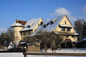
Oetlikon is a hamlet belonging to the municipality of Würenlos in the canton of Aargau . Until 1900 Oetlikon was an independent municipality. The hamlet is located in the Furttal between Hüttikon and Würenlos. The place name was first mentioned in 1040 in a document in the form of Otilingung .
history
In the 13th century there was a ministerial family in the service of the Kyburgers who named themselves after the hamlet. The manorial system and the lower jurisdiction lay with the Wettingen Monastery or its abbot . With the French invasion of Switzerland and the beginning of the Helvetic Republic in 1798, the old rulership structures were abolished. After the canton of Aargau was founded in 1803, Oetlikon was an independent municipality. In 1896 the school community Oetlikon was merged with the school communities of Kempfhof and Würenlos. In 1900 the cantonal government ordered the merger of the community with Würenlos.
Attractions
Web links
- Patrick Zehnder: Oetlikon. In: Historical Lexicon of Switzerland .


