
Mägenwil
| Mägenwil | |
|---|---|
 |
|
| State : |
|
| Canton : |
|
| District : | to bathe |
| BFS no. : | 4032 |
| Postal code : | 5506 |
| UN / LOCODE : | CH MGW |
| Coordinates : | 659 595 / 251421 |
| Height : | 422 m above sea level M. |
| Height range : | 383-563 m above sea level M. |
| Area : | 3.48 km² |
| Residents: | 2121 (December 31, 2019) |
| Population density : | 609 inhabitants per km² |
|
Proportion of foreigners : (residents without citizenship ) |
23.5% (December 31, 2019) |
| Website: | www.maegenwil.ch |
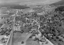
 View of Mägenwil |
|
| Location of the municipality | |
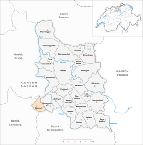  |
|
Mägenwil ( Swiss German : ˌmæɡəˈʋiːl ) is a municipality in the Swiss canton of Aargau . It belongs to the Baden district and is located between Mellingen and Lenzburg .
geography
The village is located in the south of the flat Birrfeld on a terminal moraine that was created in the Würme Ice Age when the Reuss Glacier retreated and has numerous boulders . The Birrfeld, in turn, is bounded by the steep north slope of the Wagenrain , an elongated range of hills between the Reuss valley and the Bünztal valley . In the northernmost section of the Wagenrain there are numerous abandoned quarries , in which shell limestone was once mined. The Mägenwiler Muschelkalk was formed 21 to 17 million years ago through the fossilization of mussels and snails; at that time the area of Mägenwil lay on the coast of a sea. About one kilometer east of the village center is the Eckwil district, which has completely merged with Mägenwil.
The area of the municipality is 348 hectares , of which 111 hectares are forested and 113 hectares are built over. The highest point is at 560 meters on the Meiengrün, the lowest at 409 meters on the northern municipal boundary. Neighboring communities are Birrhard in the north, Wohlenschwil in the east, Hägglingen in the south, Othmarsingen in the west and Brunegg in the north-west.
history
At the time of the Romans there was a legion camp in nearby Vindonissa ( Windisch ) . In the area south of Mägenwil, the Romans have been mining shell sandstone in quarries since the 1st century AD, which was very popular with engineers and sculptors because of its good malleability and was mainly used for sculptures, columns and milestones. Around 400 the Romans withdrew across the Alps.
In the 8th century, Alemanni immigrants founded a farming settlement. In a complaint, the place was first mentioned in a document in 893 as Maganwilare . In this document, the Fraumünster in Zurich listed people from the lower nobility who had illegally appropriated taxes, including those from Mägenwil and the surrounding area. The place name comes from the Old High German Maginwilari and means "Hofsiedlung des Mago". The hamlet of Eckwil was founded in the 11th century and was first mentioned in writing in 1271. By the 13th century, the Counts of Kyburg rose to become the dominant power in Aargau. When the family died out, their possessions passed to the Habsburgs in 1273 . The Königsfelden monastery in Windisch was an important landowner .
In 1415 the confederates conquered Aargau. Mägenwil now belonged to the Free Offices , a common rule . The villages of Mägenwil, Büblikon and Wohlenschwil as well as the hamlet of Eckwil formed the Büblikon office, which was administered by a subordinate. In 1529 the population converted to the Reformation , but in 1531, after the defeat of the Reformed towns in the Second Kappel War, they had to accept the Catholic denomination again. Mägenwil was on the denominational border, so that there were repeated disputes about the demarcation of the border between the powerful Bern and the Catholic places. The limit could not be finally determined until 1603. In March 1798 the French took Switzerland and proclaimed the Helvetic Republic . Mägenwil was then a municipality in the short-lived canton of Baden , since 1803 it has belonged to the canton of Aargau.
In the second half of the 19th century, many residents became impoverished, which is why the community urged them to emigrate overseas. The announcement of the national railway to build a railway line through Mägenwil came at just the right time. The community participated in the share capital and offered the community forest as security. The Zofingen – Wettingen line began operating on September 6, 1877. But just a year later, the company filed for bankruptcy. In order to pay off the debts, Mägenwil had to clear large areas of forest. This fiasco weighed on the community finances for decades.
From the 1960s onwards, the construction of the motorway led to a new surge in development. Numerous companies settled here and the population has more than tripled to this day. In 1963 it was planned to build an oil refinery on the newly emerging motorway . Mägenwil was not averse to this project for financial reasons, but bitter resistance arose in the surrounding communities and the cantonal government , which led to the project being abandoned in 1965. The opening of the Heitersberg tunnel on May 22, 1975 resulted in an increase in traffic on the old national railway, as it meant that the detour via Baden and Brugg was no longer necessary .
Attractions


The Loreto Chapel, built in Baroque style in 1699, is located on Lettenstrasse in Oberdorf . Individual late baroque buildings from the 18th and early 19th centuries have been preserved in the village center.
coat of arms
The blazon of the municipal coat of arms reads: "In red, yellow poppy capsule on a yellow stem with yellow leaves." The coat of arms, which was first shown on the community seal in 1872, was created due to a folk etymological misinterpretation of the place name, because in the local dialect the poppy is called Mägi .
population
The population developed as follows:
| year | 1799 | 1850 | 1900 | 1930 | 1950 | 1960 | 1970 | 1980 | 1990 | 2000 | 2010 |
| Residents | 339 | 511 | 450 | 573 | 633 | 700 | 760 | 943 | 1291 | 1551 | 1963 |
On December 31, 2019, 2,121 people lived in Mägenwil, the proportion of foreigners was 23.5%. In the 2015 census, 33.4% identified themselves as Roman Catholic and 24.2% as Reformed ; 42.4% were non-denominational or of other faiths. In the 2000 census, 88.7% stated German as their main language, 1.9% each Albanian and Serbo-Croatian , 1.5% Italian and 1.3% Turkish .
Politics and law
The assembly of those entitled to vote, the municipal assembly , exercises legislative power. The executing authority is the five-member municipal council . He is elected by the people in the majority procedure, his term of office is four years. The parish council leads and represents the parish. To this end, it implements the resolutions of the municipal assembly and the tasks assigned to it by the canton. The Baden District Court is responsible for litigation in the first instance . Mägenwil belongs to the judges' circle V (Mellingen).
economy
According to the company structure statistics (STATENT) collected in 2015, there are around 2,600 jobs in Mägenwil, 1% of them in agriculture, 19% in industry and 80% in the service sector. Numerous larger companies have settled in two industrial zones north of the railway line and on the western edge of the village. The best known are the Swedish household appliance company Electrolux , the electronics company Ascom and the electronics retailer Competec . The number of inbound and outbound commuters is roughly the same.
Up until around 1930, the mining of Mägenwil shell limestone was of great economic importance. The facades of many important buildings in Switzerland are made of Mägenwiler stone, for example the headquarters of the National Bank in Zurich or the Federal Court in Lausanne .
traffic

Mägenwil has excellent connections. The village is located on the A1 between Zurich and Bern , Switzerland's most important motorway, just a few kilometers from the Birrfeld motorway triangle, where the A3 branches off to Basel . Kantonsstrasse 268 leads to Mellingen , Kantonsstrasse 279 to Lenzburg and Kantonsstrasse 280 to Brugg .
The station is on the main SBB route between Zurich and Bern . On December 12, 2004, the national railway line to Wettingen was shut down. Instead, Mägenwil has since been replaced by the extended line S3 resp. Served since December 2018 by the S11 of the Zurich S-Bahn , which runs directly through the Heitersberg tunnel to Zurich. The village is also accessed by a post bus line to Baden and by two RBL bus lines via Möriken and Othmarsingen to Lenzburg train station . On weekends, night buses run from Baden via Mellingen and Mägenwil to Bremgarten and from Lenzburg via Mägenwil to Othmarsingen.
education
The community has a kindergarten and a school house where primary school is taught. All upper levels ( Realschule , Secondary School and District School ) can be attended in Mellingen . The closest grammar schools are the Baden Cantonal School and the Wettingen Cantonal School .
Personalities
- Max Rohr (1890–1980), politician
literature
- Andreas Steigmeier : Mägenwil. In: Historical Lexicon of Switzerland .
- Andreas Steigmeier : Mägenwil and Wohlenschwil, history of two neighboring communities . Ed .: Residential communities Mägenwil and Wohlenschwil. 1993.
- Peter Hoegger: The art monuments of the canton of Aargau . Ed .: Society for Swiss Art History . Volume VI: District of Baden I. Birkhäuser Verlag, Basel 1976, ISBN 3-7643-0782-X .
Web links
Individual evidence
- ↑ Cantonal population statistics 2019. Department of Finance and Resources, Statistics Aargau, March 30, 2020, accessed on April 2, 2019 .
- ↑ Cantonal population statistics 2019. Department of Finance and Resources, Statistics Aargau, March 30, 2020, accessed on April 2, 2019 .
- ↑ a b Beat Zehnder: The community names of the canton of Aargau . In: Historical Society of the Canton of Aargau (Ed.): Argovia . tape 100 . Verlag Sauerländer, Aarau 1991, ISBN 3-7941-3122-3 , p. 261-262 .
- ^ National map of Switzerland, sheet 1090, Swisstopo.
- ↑ Standard area statistics - municipalities according to 4 main areas. Federal Statistical Office , November 26, 2018, accessed on June 1, 2019 .
- ^ History of the Mägenwil Chapel. Katholischer Kapellenverein Mägenwil, accessed on June 2, 2012 .
- ↑ Hoegger: The monuments of Canton Aargau, Volume VI: District Baden I. S. 378-381.
- ^ Joseph Galliker, Marcel Giger: Municipal coat of arms of the Canton of Aargau . Lehrmittelverlag des Kantons Aargau, book 2004, ISBN 3-906738-07-8 , p. 207 .
- ↑ Population development in the municipalities of the Canton of Aargau since 1850. (Excel) In: Eidg. Volkszählung 2000. Statistics Aargau, 2001, archived from the original on October 8, 2018 ; accessed on June 1, 2019 .
- ↑ Resident population by religious affiliation, 2015. (Excel) In: Population and Households, Community Tables 2015. Statistics Aargau, accessed on June 1, 2019 .
- ↑ Swiss Federal Census 2000: Economic resident population by main language as well as by districts and municipalities. (Excel) Statistics Aargau, archived from the original on August 10, 2018 ; accessed on June 1, 2019 .
- ↑ circles of justice of the peace. Canton of Aargau, accessed on June 19, 2019 .
- ↑ Statistics of the corporate structure (STATENT). (Excel, 157 kB) Statistics Aargau, 2016, accessed on June 1, 2019 .
Bathing | Bellikon | Bergdietikon | Birmenstorf | Things of honor | Ennetbaden | Fislisbach | Freienwil | Gibstorf | Killwangen | Künten | Mellingen | Mägenwil | Neuenhof | Niederrohrdorf | Oberrohrdorf | Obersiggenthal | Remetschwil | Spreitenbach | Stetten | Turgi | Untersiggenthal | Wettingen | Wohlenschwil | Würenlingen | Würenlos
Former municipalities: Büblikon | Dättwil | Kempfhof | Oberehrendingen | Oetlikon | Rohrdorf | Unterehrendingen
Canton of Aargau | Districts of the Canton of Aargau | Municipalities in the Canton of Aargau