
Obersiggenthal
| Obersiggenthal | |
|---|---|
 |
|
| State : |
|
| Canton : |
|
| District : | to bathe |
| BFS no. : | 4038 |
| Postal code : | 5415 Hertenstein AG 5415 Nussbaumen AG 5415 Rieden AG 5416 Kirchdorf AG |
| UN / LOCODE : | CH NBB (Nussbaumen near Baden) |
| Coordinates : | 664 326 / 259 921 |
| Height : | 380 m above sea level M. |
| Height range : | 336–619 m above sea level M. |
| Area : | 8.36 km² |
| Residents: | 8637 (December 31, 2019) |
| Population density : | 1033 inhabitants per km² |
|
Proportion of foreigners : (residents without citizenship ) |
31.2% (December 31, 2019) |
| Website: | www.obersiggenthal.ch |
_IMG_9782_ShiftN.jpg) Walnut trees |
|
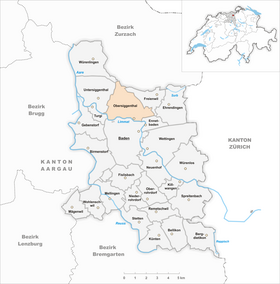
| Location of the municipality | |
  |
|
Obersiggenthal ( Swiss German : ˈɔbərsiɡəˌtɑːl ) is a municipality in the Swiss canton of Aargau . It belongs to the Baden district , is located north of the district capital Baden on the Limmat and consists of the districts of Nussbaumen, Kirchdorf , Rieden and Hertenstein.
geography

The community is located on the eastern side of the Siggental, a gravel terrace on the northern bank of the Limmat, which expands towards the northwest. In the north of the forms Tafeljura belonging Siggenberg a natural border with the Surbtal while the Limmat the town Baden separates. In the east, still in the Klus von Baden, lies the district of Rieden, on the steep slope above the hamlet of Hertenstein ( 482 m above sea level ). Nussbaumen, the center of the municipality, is in the beginning of the valley widening. The westernmost is Kirchdorf, about one kilometer from the river. The hamlet of Tromsberg ( 490 m above sea level ) is located on the slope above Kirchdorf . While Rieden and Nussbaumen have grown together, there is still a gap between Nussbaumen and Kirchdorf.
The municipal area is 836 hectares , of which 358 hectares are forest and 176 hectares are built over. The lowest point is on the Limmat at the ship mill ( 340 m above sea level ), the highest point in the Ebne area ( 618 m above sea level ). Neighboring communities are Endingen and Lengnau in the north, Freienwil in the north-east, Ennetbaden in the east, Baden in the south, Turgi in the south-west, Untersiggenthal in the west and Würenlingen in the north-west. The entire municipal boundary is about seven kilometers long.
history
People settled northwest of Kirchdorf as early as the Neolithic around 5000 years ago. Also in Kirchdorf, archaeologists discovered a Celtic grave from the Latène period and the remains of a Roman manor. The manor consisted of at least two utility buildings that were used from the second half of the 1st to the early 3rd century. The main building has not yet been found, but is believed to be in the area of the church.
In 1150 the Elchingen Monastery near Ulm sold its property in Siggenthal to the St. Blasien Monastery . The Habsburgs were the patrons of the monastery and the holders of blood jurisdiction . The place name Sikental can be found in the Habsburg land register from 1303/08 . It comes from the Old High German Sikkintale and means "Valley of the Sikko". In 1415 the Swiss conquered Aargau and Siggenthal was now part of the Siggenamt in the county of Baden , a common rule . After lengthy disputes, Kirchdorf and Nussbaumen pushed through the creation of their own community. Therefore, in 1695, the separation into Unter- and Obersiggenthal took place.
In March 1798 the French took Switzerland and proclaimed the Helvetic Republic . Obersiggenthal was initially a municipality in the short-lived canton of Baden , since 1803 it has belonged to the canton of Aargau. It was not until 1850 that the villagers managed to buy themselves out of the interest obligation of the St. Blasien monastery. In 1854 the first factory was built in Rieden , which used the hydropower of the Limmat. After the important company BBC (now ABB ) was founded in Baden in 1892 , the population skyrocketed. In 1900 it was 1504, a hundred years later it was five times as much.
Attractions

coat of arms
The blazon of the municipal coat of arms reads: "Three crossed white keys in red, the middle one with a double beard." The coat of arms is first shown on the municipal seal in 1872. It refers to the heavenly keys of the patron saint of the church of Kirchdorf, Saint Peter . The number of keys is an indication of the villages of Kirchdorf, Nussbaumen and Rieden that make up the community.
population
The population developed as follows:
| year | 1780 | 1850 | 1900 | 1930 | 1950 | 1960 | 1970 | 1980 | 1990 | 2000 | 2010 |
| Residents | 631 | 1183 | 1504 | 2193 | 2856 | 4508 | 6623 | 7442 | 7335 | 7561 | 8191 |
On December 31, 2019, 8,637 people lived in Obersiggenthal, the proportion of foreigners was 31.2%. In the 2015 census, 37.5% described themselves as Roman Catholic and 18.9% as Reformed ; 43.6% were non-denominational or of other faiths. 80.7% stated German as their main language in the 2000 census , 4.8% Serbo-Croatian , 2.6% Italian , 1.8% English , 1.6% each of Albanian and Turkish , 1.2% French , 0, 9% Spanish and 0.7% Portuguese .
Politics and law
legislative branch
Instead of a usual in smaller communities Municipal Assembly represented the company since 1974, chosen by the voters Obersiggenthaler local parliament, the Einwohnerrat , the concerns of the population. It consists of 40 members who are each elected for four years by proportional representation. He is responsible for approving the tax rate , the budget, the annual accounts, the annual report and the loans. It also issues regulations, controls the conduct of office of the executive and decides on naturalizations . The residents' councils can submit parliamentary proposals ( motion , postulate , small questions ).
The graphic on the right shows the composition of the residents' council after the election on September 24, 2017. In the last six elections, the parties achieved the following number of seats:
| Political party | 1997 | 2001 | 2005 | 2009 | 2013 | 2017 |
|---|---|---|---|---|---|---|
| CVP | 10 | 11 | 12 | 12 | 11 | 11 |
| SVP | 9 | 11 | 10 | 11 | 10 | 9 |
| SP | 7th | 8th | 8th | 7th | 7th | 8th |
| FDP | 9 | 7th | 8th | 6th | 6th | 6th |
| Green | 2 | 3 | 3 | |||
| EPP | 2 | 2 | 2 | 2 | 2 | 2 |
| BDP | 1 | 1 | ||||
| SD | 1 | |||||
| Boy list | 3 |
Various elements of direct democracy can also be found at the level of the resident community . The population is entitled to optional and compulsory referendums as well as the popular initiative .
executive
The executing authority is the five-member municipal council . He is elected by the people for four years in a majority process . The municipal council leads and represents the community of residents. To this end, it implements the resolutions of the residents' council and the tasks assigned to it by the canton.
Judiciary
The Baden District Court is responsible for litigation in the first instance . Obersiggenthal belongs to the Friedensrichterkreis III (Baden).
economy
According to the corporate structure statistics (STATENT) collected in 2015, Obersiggenthal has around 1950 jobs, of which 2% are in agriculture, 22% in industry and 76% in the service sector. Obersiggenthal is primarily a residential community; most of the employed people are commuters and work in neighboring Baden .
traffic

The busy canton road 295 leads through Obersiggenthal from Baden through the lower Limmat valley to Würenlingen . The Siggenthaler Brücke has been crossing the Limmat since September 2002 and connects Nussbaumen directly with Baden; it is 247 meters long and has an arch span of 115 meters.
The community is connected to the public transport network by two bus routes operated by the RVBW bus company . Line 2, which runs every 15 minutes at peak times, starts in Untersiggenthal and runs over the Schiefe Brücke via Ennetbaden to Baden, Wettingen and Spreitenbach . Line 6 also starts in Untersiggenthal during peak times (at the Landschreiber during off-peak times in Obersiggenthal) and goes to Baden and Rütihof . On weekends there is a night bus from Baden via Obersiggenthal to Würenlingen.
education
There are four kindergartens and four primary schools . The secondary school , the secondary school and the district school are run in the Obersiggenthal upper school center (OSOS) . The closest grammar schools are the Baden Cantonal School and the Wettingen Cantonal School .
Personalities
- Walter Drack (1917–2000), archaeologist and monument conservator
- Liliane Juchli (* 1933), religious sister
literature
- Patrick Zehnder: Obersiggenthal. In: Historical Lexicon of Switzerland .
- Sarah Brian Scherer: Kirchdorf (AG). In: Historical Lexicon of Switzerland .
- Peter Hoegger: The art monuments of the canton of Aargau . Ed .: Society for Swiss Art History . Volume VII: District of Baden II. Birkhäuser Verlag, Basel 1995, ISBN 3-909164-44-7 , p. 89-110 .
Web links
Individual evidence
- ↑ Cantonal population statistics 2019. Department of Finance and Resources, Statistics Aargau, March 30, 2020, accessed on April 2, 2019 .
- ↑ Cantonal population statistics 2019. Department of Finance and Resources, Statistics Aargau, March 30, 2020, accessed on April 2, 2019 .
- ↑ a b Beat Zehnder: The community names of the canton of Aargau . In: Historical Society of the Canton of Aargau (Ed.): Argovia . tape 100 . Verlag Sauerländer, Aarau 1991, ISBN 3-7941-3122-3 , p. 331-332 .
- ^ National map of Switzerland, sheet 1070, Swisstopo.
- ↑ Standard area statistics - municipalities according to 4 main areas. Federal Statistical Office , November 26, 2018, accessed on June 8, 2019 .
- ^ Martin Hartmann, Hans Weber: The Romans in Aargau . Verlag Sauerländer, Aarau 1985, ISBN 3-7941-2539-8 , p. 192-193 .
- ^ Joseph Galliker, Marcel Giger: Municipal coat of arms of the Canton of Aargau . Lehrmittelverlag des Kantons Aargau, book 2004, ISBN 3-906738-07-8 , p. 241 .
- ↑ Population development in the municipalities of the Canton of Aargau since 1850. (Excel) In: Eidg. Volkszählung 2000. Statistics Aargau, 2001, archived from the original on October 8, 2018 ; accessed on June 8, 2019 .
- ↑ Resident population by religious affiliation, 2015. (Excel) In: Population and Households, Community Tables 2015. Statistics Aargau, accessed on June 8, 2019 .
- ↑ Swiss Federal Census 2000: Economic resident population by main language as well as by districts and municipalities. (Excel) Statistics Aargau, archived from the original on August 10, 2018 ; accessed on June 8, 2019 .
- ↑ Minutes of the general renewal elections of the residents' council 2018/2021. (PDF; 1.1 MB) City of Zofingen, September 24, 2017, accessed on October 2, 2017 .
- ↑ circles of justice of the peace. Canton of Aargau, accessed on June 18, 2019 .
- ↑ Statistics of the corporate structure (STATENT). (Excel, 157 kB) Statistics Aargau, 2016, accessed on June 8, 2019 .
- ↑ Siggenthal is getting closer to Baden. Neue Zürcher Zeitung , September 4, 2002, accessed on June 8, 2019 .
Bathing | Bellikon | Bergdietikon | Birmenstorf | Things of honor | Ennetbaden | Fislisbach | Freienwil | Gibstorf | Killwangen | Künten | Mellingen | Mägenwil | Neuenhof | Niederrohrdorf | Oberrohrdorf | Obersiggenthal | Remetschwil | Spreitenbach | Stetten | Turgi | Untersiggenthal | Wettingen | Wohlenschwil | Würenlingen | Würenlos
Former municipalities: Büblikon | Dättwil | Kempfhof | Oberehrendingen | Oetlikon | Rohrdorf | Unterehrendingen
Canton of Aargau | Districts of the Canton of Aargau | Municipalities in the Canton of Aargau