
Gibstorf
| Gibstorf | |
|---|---|
 |
|
| State : |
|
| Canton : |
|
| District : | to bathe |
| BFS no. : | 4029 |
| Postal code : | 5412habenstorf 5412 Vogelsang AG |
| Coordinates : | 660 581 / 259 058 |
| Height : | 376 m above sea level M. |
| Height range : | 326-565 m above sea level M. |
| Area : | 5.65 km² |
| Residents: | 5460 (December 31, 2019) |
| Population density : | 966 inhabitants per km² |
|
Proportion of foreigners : (residents without citizenship ) |
26.9% (December 31, 2019) |
| Website: | www.habenstorf.ch |
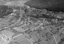
 View to the north on Gibstorf, in the background the Lower Aare Valley |
|
| Location of the municipality | |
  |
|
Gebenstorf ( Swiss German : Gäbischtorf, ɡæbiʃˌtɔrf ) is a municipality in the Swiss canton of Aargau . It belongs to the Baden district and is located in the middle between Baden and Brugg . Until 1884 the village of Turgi belonged to Gibstorf before it became its own municipality.
geography

The community is located near the moated castle of Switzerland , where three of the five largest rivers in Switzerland - Aare , Limmat and Reuss - come together. About one kilometer north of the village center, the Reuss flows into the Aare, and another kilometer further away is the mouth of the Limmat. The old village center lies on a terrace between the east bank of the Reuss and the western slope of the Gibstorfer Horn, an elevation of the Table Jura . The valley of the Hölibach , which flows into the Reuss to the west of the village center, takes up a large part of the southern community area. In the loop of the river Reuss lies the young district called Reuss , which has grown together with Gibstorf.
Aare and Limmat form a 900 meter long and 300 meter wide peninsula on which the village of Vogelsang is located. The peninsula is cut through by a man-made power station canal that served as an energy source for a former cotton mill. At the mouth of the Aare and Limmat there are three islands formed from sediments .
The area of the municipality is 565 hectares , of which 227 hectares are forested and 157 hectares are built over. The highest point is 561 m above sea level. M. on the Chörnlisberg, part of the Gibstorfer Horn, the deepest at 328 m above sea level. M. north of Vogelsang at the confluence of the Aare and Limmat rivers. Neighboring communities are Untersiggenthal in the north, Turgi in the northeast, Baden in the east, Birmenstorf in the south, Windisch in the west and Brugg in the northwest.
history
From the 1st century AD, the Roman road led from the legionary camp Vindonissa to Aquae Helveticae (today Baden ) through what is now the municipality. This knowledge has been secured since 1534: At that time a farmer in Wil (now part of Turgi ) found a Roman milestone while plowing his field , which is now on display in the National Museum Zurich . Roman soldiers' graves came to light in the Vogelsang district. The tombstone of a soldier of Legio XI Claudia is walled up in the reformed church.
A village emerged in the 8th century when Alemannic settlers settled here. The districts of Reuss and Vogelsang as well as the two "Berghöfe" Schwabenberg and Petersberg on the Gibstorfer Horn were built between 1000 and 1200. The first mention of the village as Gobistorf took place in 1247 when the Habsburgs bought the village's church. The place name comes from the Old High German Gebinesthorf and means "village of the Gebin". In 1330, the Habsburgs transferred their property and their rights inhabenstorf to the Königsfelden monastery in Windisch , with the exception of blood jurisdiction . On December 26, 1351, before the battle of Dättwil , the village was sacked by the people of Zurich.
In 1415 the Confederates conquered Aargau and Gibstorf now formed its own office in the County of Baden , a common rule . During the Reformation of 1529, around half of the population converted to the new denomination. After the Second Kappel War of 1531, the Reformation in the county of Baden was largely reversed. But Gibstorf was one of the few exceptions that remained religiously mixed. Both denominations shared the Church of St. Margaretha for centuries. In September 1769, Johann Heinrich Pestalozzi and Anna Schulthess married there. In June 1889 the Margaretenkirche had to be demolished because of dilapidation and both denominations built their own places of worship. The Catholic parish church was consecrated in 1889, the Reformed church in November 1891.
In March 1798 the French took Switzerland and proclaimed the Helvetic Republic . Gibstorf was initially a municipality in the short-lived canton of Baden , since 1803 it has belonged to the canton of Aargau. Industrialization took hold in 1826 when the Bebié brothers built their first factory in the open fields in Turgi , far from the village. A proletarian industrial workers' settlement emerged out of nowhere, the inhabitants of which came from all parts of Switzerland and from neighboring countries. On September 29, 1856, a train station was opened there on the Baden - Brugg line.
The contrast between the long-established Gibstorfern and the colorfully mixed Turgemer grew bigger and bigger. Although Turgi now had more inhabitants, its inhabitants were regularly outvoted at community meetings, as the population of the new village had a high proportion of young people and foreigners who were not entitled to vote. The situation only eased when Turgi separated from Gibstorf on January 1, 1884 and formed an independent community. In the meantime, however, numerous industrial companies had also settled in Gibstorf, above all in Vogelsang.
After the outbreak of the Second World War , the Swiss Army established and occupied the first army position with the Limmat position in October 1939 . The barrier point at Gibstorf, with numerous bunkers and anti-tank barriers, most of which still exist today, was one of several lines of defense staggered downwards from the border. It had to stop a possible breakthrough of the German armed forces in the narrow point between Bruggerberg and Gibstorfer Horn . From 1940 to 1943 around 300 Polish soldiers who had fled the German Wehrmacht lived in an internment camp near Gibstorf. Because of its excellent traffic situation between Brugg and Baden, from 1950 on, Gibstorf developed into a preferred place of residence. As in the 19th century, the community experienced a surge in growth and gradually changed from an industrial village to a residential community for commuters. The population doubled within fifty years.
Attractions
_IMG_6764.jpg)
_IMG_6784.jpg)
coat of arms
The blazon of the municipal coat of arms reads: "Split from red with a white pruning knife and from white with a red ploughshare ." The first image of the coat of arms appeared on the municipal seal in 1872. The vine knife and the ploughshare were once the most important branches of the community, viticulture and agriculture.
population
The population developed as follows:
| year | 1798 | 1850 | 1900 | 1930 | 1950 | 1960 | 1970 | 1980 | 1990 | 2000 | 2010 |
| Residents | 630 | 1796 | 1574 | 1955 | 2110 | 2728 | 3539 | 3610 | 4079 | 4182 | 4664 |
As of December 31, 2019, 5,460 people lived in Gibstorf, the proportion of foreigners was 26.9%. In the 2015 census, 32.7% described themselves as Roman Catholic and 22.4% as Reformed ; 44.9% were non-denominational or of other faiths. In the 2000 census, 83.3% stated German as their main language, 4.8% Italian , 2.3% Albanian and Serbo-Croatian , 1.0% French , 0.8% English and Portuguese and 0.7% Turkish .
Politics and law
The assembly of those entitled to vote, the municipal assembly , exercises legislative power. The executing authority is the five-member municipal council . He is elected by the people in the majority procedure, his term of office is four years. The parish council leads and represents the parish. To this end, it implements the resolutions of the municipal assembly and the tasks assigned to it by the canton. The Baden District Court is responsible for litigation in the first instance . Gibstorf belongs to the Friedensrichterkreis V (Mellingen).
economy
According to the company structure statistics (STATENT) collected in 2015, there are around 1700 jobs in Gibstorf, of which 2% are in agriculture, 30% in industry and 68% in the service sector. Most of the workers are commuters and work in the nearby towns of Brugg and Baden .
The BAG in Vogelsang, which existed from 1909 to 1998, was one of the largest manufacturers of lights in Switzerland for several decades. The former BAG power plant produces electricity as a power plant into the AEW Energie supply network . After production ceased, the BAG handed over a large collection of documents and products from the company's history to the State Archives of the Canton of Aargau and the Museum Aargau. In the meantime, the successor company BAG Immobilien is reactivating the former factory site in Vogelsang.
traffic
The main road 3 between Brugg and Baden runs through the village . It has been crossing the Reuss between Windisch andhabenstorf since 1799 and 1832 on a road bridge, which is still called the "Zollbrücke" in memory of the former customs office; the new prestressed concrete bridge dates from 1982. And a small, concreted footbridge from 1916 leads below the Reuss weir at the former Kunz spinning mill across the river. In the Vogelsang district, a bridge each spans the Aare and the Limmat. The Baden-West connection to the A1 motorway is around four kilometers south-east near Dättwil .
The Brugg-Baden railway line crosses the Reuss on the Turgi bridge and crosses the municipality of Gibstorf, which, however, has no longer had its own train station since the separation from Turgi.
Gibstorf is the terminus of an RVBW bus line to Baden train station and Würenlos . This is also where the post bus line begins via Turgi and Untersiggenthal to Würenlingen . Another post bus line runs from Brugg train station via Gibstorf to Mellingen Heitersberg train station (connection to the Zurich S-Bahn ). On the weekends, a night bus runs from Baden via Gibstorf and Birmenstorf back to Baden.
The end point of the canoe route on the Reuss, which begins in Bremgarten , is at Gibstorf.
education
Gibstorf has four kindergartens and three school houses in which the primary school , the secondary school and the secondary school are housed. The district school can be attended in Turgi . The closest grammar schools are the Baden Cantonal School and the Wettingen Cantonal School .
Personalities
- Albrecht Rengger (1764–1835), politician
- Karl Killer (1878–1948), politician
- Meinrad Busslinger (* 1952), molecular biologist and immunologist
- Daniel Gygax (* 1981), soccer player, grew up in Gibstorf
- Tanja Bachmann (* 1981), singer of the pop group TinkaBelle , from Vogelsang
literature
- Andreas Steigmeier : Gibstorf. In: Historical Lexicon of Switzerland .
- Dominik Sauerländer, Andreas Steigmeier: Prosperity is only shared by a few - From the history of the community of Gibstorf . Ed .: Residential community Gibstorf. Gibstorf 1997, DNB 953201538 .
- Peter Hoegger: The art monuments of the canton of Aargau . Ed .: Society for Swiss Art History . Volume VII: District of Baden II. Birkhäuser Verlag, Basel 1995, ISBN 3-909164-44-7 , p. 35-52 .
Web links
Individual evidence
- ↑ Cantonal population statistics 2019. Department of Finance and Resources, Statistics Aargau, March 30, 2020, accessed on April 2, 2019 .
- ↑ Cantonal population statistics 2019. Department of Finance and Resources, Statistics Aargau, March 30, 2020, accessed on April 2, 2019 .
- ↑ a b Beat Zehnder: The community names of the canton of Aargau . In: Historical Society of the Canton of Aargau (Ed.): Argovia . tape 100 . Verlag Sauerländer, Aarau 1991, ISBN 3-7941-3122-3 , p. 171-172 .
- ↑ a b National map of Switzerland, sheet 1070, Swisstopo.
- ↑ Standard area statistics - municipalities according to 4 main areas. Federal Statistical Office , November 26, 2018, accessed on June 4, 2019 .
- ^ Martin Hartmann, Hans Weber: The Romans in Aargau . Verlag Sauerländer, Aarau 1985, ISBN 3-7941-2539-8 , p. 170 .
- ^ Joseph Galliker, Marcel Giger: Municipal coat of arms of the Canton of Aargau . Lehrmittelverlag des Kantons Aargau, book 2004, ISBN 3-906738-07-8 , p. 163 .
- ↑ Population development in the municipalities of the Canton of Aargau since 1850. (Excel) In: Eidg. Volkszählung 2000. Statistics Aargau, 2001, archived from the original on October 8, 2018 ; accessed on June 4, 2019 .
- ↑ Resident population by religious affiliation, 2015. (Excel) In: Population and Households, Community Tables 2015. Statistics Aargau, accessed on June 4, 2019 .
- ↑ Swiss Federal Census 2000: Economic resident population by main language as well as by districts and municipalities. (Excel) Statistics Aargau, archived from the original on August 10, 2018 ; accessed on June 4, 2019 .
- ↑ circles of justice of the peace. Canton of Aargau, accessed on June 18, 2019 .
- ↑ Statistics of the corporate structure (STATENT). (Excel, 157 kB) Statistics Aargau, 2016, accessed on June 4, 2019 .
- ↑ Documentation BAG (PDF)
- ↑ Pirmin Kramer: Former Vogelsang industrial area is to become a modern residential area. Aargauer Zeitung , April 1, 2014, accessed on June 4, 2019 .
- ^ Josef Killer: Bridges in Aargau. Bridges from Roman times to 1940. In: Schweizer Ingenieur und Architekt, 105, 1987, p. 641.
- ↑ No longer secure: Reussbrücke will be blocked immediately on: srf.ch, accessed on September 9, 2019.
- ↑ Reuss canoe route at www.kanuland.ch
Bathing | Bellikon | Bergdietikon | Birmenstorf | Things of honor | Ennetbaden | Fislisbach | Freienwil | Gibstorf | Killwangen | Künten | Mellingen | Mägenwil | Neuenhof | Niederrohrdorf | Oberrohrdorf | Obersiggenthal | Remetschwil | Spreitenbach | Stetten | Turgi | Untersiggenthal | Wettingen | Wohlenschwil | Würenlingen | Würenlos
Former municipalities: Büblikon | Dättwil | Kempfhof | Oberehrendingen | Oetlikon | Rohrdorf | Unterehrendingen
Canton of Aargau | Districts of the Canton of Aargau | Municipalities in the Canton of Aargau