
Switzerland's moated castle

As the water castle of Switzerland the area in the triangle of is Brugg , Windisch , Gebenstorf , Turgi , Stilli and Untersiggenthal called on the southern edge of the Jura, where the three of the Alps coming rivers Aare , Reuss and Limmat join the district Vogelsang at Gebenstorfer. From there, the Aare flows northwards through a wide transverse valley of the Jura and reaches the Rhine near Koblenz .
Hydrology
The outflow of the three combined bodies of water below the Limmat estuary averages 555 m³ of water per second. The Aare contributes 315 m³ / s, the Reuss 140 m³ / s and the Limmat 100 m³ / s. In the event of floods, the amount of water can almost triple.
geography
From the river systems of the Aare, the Reuss and the Limmat with the more important tributaries Zihl , Saane , Emme , Sarner Aa and Linth , the water from 40% of the total area of Switzerland flows together in the canton Aargau . The catchment area includes Central Switzerland , the Bernese Oberland , the Freiburg Pre-Alpine Area, large parts of the Mittelland cantons of Aargau, Neuchâtel , Vaud , Solothurn and Zurich , the Canton of Glarus and the western regions of the Canton of St. Gallen . Below the moated castle, the Aare is the most water-rich river that flows exclusively through Swiss territory; at the confluence with the Rhine in Koblenz it carries 50% more water than this.
The moated castle is surrounded at the four "angles" by ridges that tower above the river valleys by 150 to 200 meters. B. the Bruggerberg (518 m) above Brugg.
natural reserve
In 1989 the Great Council of the Canton of Aargau protected the floodplain landscape with the so-called moated castle decree. The area is considered a floodplain of national importance . It is classified in the category of important Swiss landscapes .
technology
Several hydropower plants have been built in the vicinity of Brugg and numerous bridges cross the rivers. The industrial culture path Limmat – Wasserschloss provides information about the technological history of the region .
photos

View of the moated castle from Gibstorfer Horn

The confluence of the Aare and Reuss rivers, view from the railway bridge over the Reuss

The Limmatspitz nature reserve from Pro Natura Aargau at the confluence of the Aare and Limmat rivers

View of the moated castle from Bruggerberg
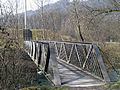
Footbridge on the Limmatspitz built by Field Division 5


_IMG_6765.jpg)


Web links
Individual evidence
- ↑ Documentation Aare floods. ( Memento from November 30, 2016 in the Internet Archive )
- ↑ Aare flood protection report.
- ↑ Flood statistics at Brugg gauge.
- ↑ Untersiggenthal measuring station 2013.
- ↑ Decree on the protection of the Aare – Reuss – Limmat estuary.
Coordinates: 47 ° 29 ′ 42 " N , 8 ° 14 ′ 12" E ; CH1903: six hundred and sixty thousand one hundred and thirty / 260,785