Sarner Aa
|
Sarner Aa Sarneraa, Giswileraa (upper course), Dreiwässerkanal |
||
|
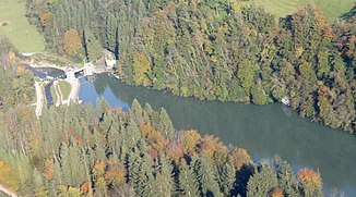
Aerial view of the Wichelsee with the outflow of the Sarner Aa |
||
| Data | ||
| Water code | CH : 712 | |
| location | Switzerland | |
| River system | Rhine | |
| Drain over | Reuss → Aare → Rhine → North Sea | |
| source | in Lungernsee 46 ° 48 ′ 47 ″ N , 8 ° 10 ′ 12 ″ E |
|
| Source height | 688 m above sea level M. | |
| muzzle | in the Alpnachersee coordinates: 46 ° 57 ′ 6 " N , 8 ° 17 ′ 43" E ; CH1903: 665 211 / 200414 46 ° 57 '6 " N , 8 ° 17' 43" O |
|
| Mouth height | 434 m above sea level M. | |
| Height difference | 254 m | |
| Bottom slope | 24 ‰ | |
| length | 10.4 km | |
| Catchment area | 336.21 km² | |
| Discharge at the mouth of the A Eo : 336.21 km² |
MQ Mq |
12.67 m³ / s 37.7 l / (s km²) |
| Left tributaries | Giswiler Lauibach , Grosse Schliere | |
| Right tributaries | Little Melchaa , Big Melchaa | |
| Flowing lakes | Sarnersee | |
| Reservoirs flowed through | Wichelsee | |
The Sarner Aa (rarely also Sarneraa ) is an approximately 10 kilometer long tributary of Lake Lucerne in the canton of Obwalden in central Switzerland .
course
The Sarner Aa rises from the Lungernsee , which it leaves overturned. In a small forest near Mutzenloch , it then comes to the surface for the first time.
The hydropower in the area of the 190 m high valley between the Lungernsee and Giswil is used by the Lungerersee power station. That is why the runoff from the Lungernsee near Kaiserstuhl is routed underground through a pressure tunnel. After the hydropower in the underground power plant center Unteraa was used to generate electricity, the river in Aaried, the valley floor south of Giswil, comes to light again. From here it is called Aa or Aawasser in its middle course . It flows through Giswil and joins the Giswil Lauibach from the west. As a three-water canal , the river flows into the Sarnersee after 2 km north of Giswil . The Small Melchaa flows since the completion of the flood control project in 2015 is no longer in the three-water channel, but directly into the Sarnersee.
Another important tributary is the Grosse Melchaa , which flows into the Sarnersee between Sachseln and Sarnen . Until the diversion for flood protection reasons in 1880, the Grosse Melchaa did not flow into Lake Sarnen, but along the outskirts of Sarnen and flowed north of Sarnen into the Sarner Aa.
In the lower reaches north of the Sarnersee the river is now called Sarner Aa . It flows canalised and straightened in the Sarneraatal to the north-northeast through Sarnen and the Wichelsee , which is under nature protection. From the barrage of the Wichelsee, most of the water flows through a 1,860 m long pressure tunnel with a net gradient of 23 m to the Eichi low-pressure run-of-river power plant and from there flows back into the river bed. Before that, the Sarner Aa takes in the water of the Grosse Schliere from the left . It then flows along the western foot of the Mueterschwanderberg and flows into the Alpnachersee east of Alpnachstad .
Flood
During the floods in August 2005 , the Sarner Aa flooded large areas below the Sarner lake. In order to prevent such events, the Sarner Aa is to be increased to a capacity of 150 m³. In order to achieve this protection goal, the people of Obwalden decided in a referendum on September 26, 2010 that the two project variants “Sarneraa with flood relief tunnel east” and “Sarneraa deepened and widened” should be worked out on the same planning level. In 2014, the government council decided in favor of the “Sarneraa with flood relief tunnel east” variant and then submitted a corresponding bill for the planning, construction and implementation of this variant to the cantonal council, which it approved. On September 28, 2014, the Obwalden electorate also said yes to the proposal.
See also
Web links
Individual evidence
- ↑ a b Geoserver of the Swiss Federal Administration ( information )
- ↑ Hydrological Atlas of Switzerland of the Federal Office for the Environment FOEN, Table_13
- ↑ a b Modeled mean annual discharge. In: Topographical catchment areas of Swiss waters: sub-catchment areas 2 km². Retrieved August 31, 2017 .
- ↑ Flood protection Obwalden - Kleine Melchaa ( Memento of the original from December 3, 2014 in the Internet Archive ) Info: The archive link has been inserted automatically and has not yet been checked. Please check the original and archive link according to the instructions and then remove this notice. Website of the Building and Spatial Development Department of the Canton of Obwalden, accessed May 4, 2017
- ↑ Flood protection Obwalden - Sarner Aa Website of the building and spatial development department of the canton Obwalden, accessed on May 4, 2017
