
Lungerersee
| Lungerersee | ||
|---|---|---|

|
||
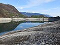
| Lungernsee: View from the Kaiserstuhl | ||
| Geographical location | Obwalden , Switzerland | |
| Tributaries | Lauibach , Eibach , (Melchaa) | |
| Drain | Sarner Aa | |
| Places on the shore | Lounging | |
| Data | ||
| Coordinates | 655 320 / 183737 | |
|
||
| Altitude above sea level | 689 m above sea level M. | |
| surface | 2.01 km² | |
| scope | 10.317 km | |
| Maximum depth | 68 m | |
|
particularities |
Natural reservoir |
|

|
||

The Lungerersee , also Lungernsee , more rarely written Lungerensee , is a natural reservoir in the canton of Obwalden . The lake can be reached from the Brünig Pass or from Lucerne through the Sarneraatal . Lungern and its districts Kaiserstuhl-Bürglen and Obsee are located on the lake .
history
In order to preserve new land for the community, which has little cultivated land, the idea of lowering the lake was discussed as early as 1700. In the 18th century, the deepening of the lake was tackled. The village was divided into those who opposed and supporters of subsidence, the "wet" and the "dry". It took from 1790 to 1836, after hard work, until a 420 meter long tunnel was completed. With its help, the lake was restored from its original level of 675 m above sea level. M. at 657 m above sea level. M. lowered. This enabled 170 hectares of land to be gained. To mark the 175th anniversary of this event, Luke Gasser and Riodi Gasser shot the documentary “Härdepfel im See”.
In 1921, just 85 years later, the lake was dammed again for the operation of a power station and the additional land was lost again, see also the section Lowering the Lungernsee in the article on Lungern. The construction of the dam was carried out in two stages. Construction began in 1921, the first damming in autumn 1921 and the start of operations in 1922. In 1926, the damming to today's level took place in the second stage.
In March 1999, two bodies cemented in oil drums were found on the bank at low tide. The murderer from western Switzerland did not know that the lake level is lower in winter and that a broad strip of shore is no longer under water.
tourism
The lake is marketed as a «fishermen's paradise». In Lungern there is a seaside resort and a sailing school. At the southern end of the lake there is a campsite right by the lake. In 2004 there were plans to build a water ski lift for wakeboarders in the lake in order to stimulate tourism in the region. However, the plans did not materialize. A disadvantage for the tourist use of the lake is that the water level is much lower in winter because of the electricity production. On the cantonal road to the Brünig Pass, there is a lookout point at Chälrütirank , from which the lake and large parts of the Sarneraatals as far as Pilatus and Lopper can be seen.
Use for electricity generation
The Lungerersee has been used to generate electricity since it was dammed in 1921. After a net gradient of 190 meters, the water in the reservoir in the Unteraa power plant (formerly Lungererseewerk) in Giswil drives three turbines that generate electricity for the public power grid and to operate the Zentralbahn . A fourth turbine turbines the water of the Melchtäler in the so-called back pressure operation, respectively. Siphon operation in the Lungerersee. Due to the lower inflow in winter, the water level in the Lungerersee drops by up to 40 meters and rises again in spring when the snow melts. In the winter months, the usable gradient in machine group 4 is even increased in accordance with the lower sea level and thus valuable additional energy is generated with the same process water. The concession agreement for the Obwalden electricity company (EWO) stipulates that the lake level must be between 648.74 and 688.74 meters, with a level between 687.50 and 688.50 meters to be maintained in the summer months. If the level is violated, the Obwalden electricity company has to pay a fine.
gallery

Low water in winter near Obsee
Low water with dam and Mönch

View across the lake to the north

Looking north across the lake on a postcard from the period 1890 to 1900

View across the lake to the south on a postcard from the period 1890 to 1900


See also
Web links
- Edy von Wyl: Lungernsee. In: Historical Lexicon of Switzerland .
- Level of the Lungersee (last 7 days) on the website of the Obwalden electricity company
- Management of Lungerersee on the website of the Obwalden electricity company
Individual evidence
- ↑ a b c d Seen (Federal Office for the Environment FOEN). Retrieved January 18, 2020 .
- ↑ The “wet” and the “dry”, addition to the article Stabiler Lungerersee-Spiegel is possible ( Memento from March 18, 2012 on WebCite ), article from ONZ Obwalden and Nidwalden Zeitung from May 2, 2011. Archived from the original online Version on March 18, 2012.
- ↑ Lungers celebrate their lake, memory of lowering 175 years ago ( memento from March 18, 2012 on WebCite ), article in the ONZ Obwalden and Nidwalden newspaper from January 10, 2011. Archived from the original online version on March 18, 2012.
- ↑ Open the cinema doors with the Härdepfel, Lungern celebrated 175 years of subsidence ( memento from March 18, 2012 on WebCite ), article by ONZ Obwalden and Nidwalden Zeitung from September 13, 2011. Archived from the original online version on March 18, 2012.
- ^ Website Fischerparadies Lungern of Lungerersee AG
- ↑ GDB 752.51 - Concession to utilize the hydropower of the Lungerersee and the Small and Large Melchaa (PDF; 248 kB) from July 12, 1983
Swiss lakes with an area of over 1 km² (without artificial reservoirs ):
Aegeri | Baldeggersee | Lake Biel | Lake Constance | Lake Brienz | Lake Geneva | Greifensee | Hallwilersee | Lac de Joux | Lake Poschiavo | Langensee | Lauerzersee | Lake Lugano | Lungerersee | Lake Murten | Lake Neuchâtel | Oeschinensee | Pfäffikersee | Sarnersee | Sempachersee | Silsersee | Lake Silvaplana | Lake Thun | Lake Lucerne | Walensee | Lake Zug | Lake Zurich
Swiss reservoirs with a content of over 10 million m³:
Albignasee |
Arnensee |
Lac de Barberine |
Lago Bianco |
Lac Brenet |
Lago dei Cavagnöö |
Lac de Cleuson |
Lai da Curnera |
Davosersee |
Lac des Dix |
Lac d'Emosson |
Engstlensee |
Gelmersee |
Gigerwaldsee |
Göscheneralpsee |
Lake Gruyère |
Griessee |
Grimselsee |
Lac de l'Hongrin |
Klingnau Reservoir |
Klöntalersee |
Lake Lei |
Limmerensee |
Lake Livigno |
Lake Lucendro |
Lungerersee |
Lake Luzzone |
Lai da Marmorera |
Mattmarksee |
Lac de Mauvoisin |
Lac de Moiry |
Lac de Montsalvens |
Lac de Moron |
Muttsee |
Lai da Nalps |
Lake Naret |
Oberaarsee |
Lac de Pérolles |
Lake Poschiavo |
Raeterichsbodensee |
Lake Ritóm |
Lac de Salanfe |
Lago del Sambuco |
Schiffenensee |
Sihlsee |
Lai da Sontga Maria |
Sufnersee |
Lac des Toules |
Lake Tremorgio |
Lac de Tseuzier |
Lac du Vieux Emosson |
Lake Vogorno |
Wägitalersee |
Wohlensee |
Zervreila Lake