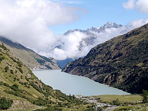
Lac des Toules
| Lac des Toules | |||||||||
|---|---|---|---|---|---|---|---|---|---|
|
|||||||||
|
|
|||||||||
| Coordinates | 581 367 / 85059 | ||||||||
| Data on the structure | |||||||||
| Lock type: | Arch dam | ||||||||
| Height above valley floor: | 86 m | ||||||||
| Height above the river bed : | 75 m | ||||||||
| Crown length: | 460 m | ||||||||
| Operator: | Sté Forces Motrices du Grand-St-Bernard | ||||||||
| Data on the reservoir | |||||||||
| Water surface | 61 ha | ||||||||
| Reservoir length | 2 km | ||||||||
| Storage space | 20.15 million m³ | ||||||||
| Catchment area | 37.6 km² | ||||||||
The Lac des Toules is a reservoir in the Swiss canton of Valais in the municipality of Bourg-St-Pierre , which is mainly formed by the Dranse d'Entremont river . The associated Les Toules dam was completed in 1963. The water level reaches an average height of 1810 m above sea level. M.
location
The reservoir extends from the south to the north where the dam is located. Alongside the upper reaches of the La Dranse , the Torrent des Erbets stream from the Combe des Planards flows from the west and the Torrent de Pieudet from the east with water from the Mont Vélan massif . The water surface of the reservoir has no branches into the side valleys because of the steep slopes.
reachability
The reservoir can be reached from the Swiss side via Martigny through the Val d'Entremont and is located on the national road 21, which leads over the Great Saint Bernard to the Aosta region . The last larger place below the reservoir is Bourg-St-Pierre . When the water level is high, the reservoir extends close to the entry lanes to the Grosser St. Bernhard tunnel . National road 21 runs above the eastern bank and is protected there by a gallery . A dirt road runs on the western side.
literature
- Office fédéral de topographie (ed.): Carte Nationale de la Suisse. Mont Blanc, Grand Combin . Assemblage 1: 50,000, 1999.
- Federal Office of Topography, swisstopo (ed.): Carte Nationale de la Suisse. Feuille 292, Courmayeur . 1: 50,000, 2003.
Web links
- the Lac des Toules at the Swiss Dam Committee


