Val d'Entremont
| Val d'Entremont | ||
|---|---|---|
|
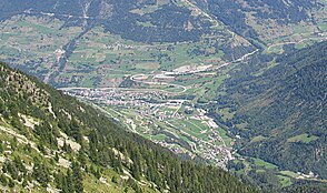
Junction between the Val d'Entremont (above) and the Val Ferret (below) near Orsières . |
||
| location | Switzerland | |
| Waters | Dranse d'Entremont , Lac des Toules | |
| Mountains | Valais Alps (Alps) | |
| Geographical location | 581.5 thousand / 90594 | |
|
|
||
| Type | Trough valley | |
| length | 30 km | |
The Val d'Entremont is a valley in Switzerland in the Entremont district in Valais . With the Great St. Bernhard (2469 m above sea level) and the Great St. Bernhard Tunnel via Hauptstrasse 21, the valley represents a connection to neighboring Italy .
geography
The Val d'Entremont, through which the Dranse d'Entremont flows, meets the Val de Bagnes at the level of the municipality of Sembrancher . With the Dranse de Bagnes the Dranse d'Entremont is the river Dranse that at Martigny in the Rhone flows. The valley merges into the Rhone valley at Martigny .
From Sembrancher downstream, the valley faces south. At the height of Orsière it divides into two parts: the eastern side valley forms the Val Ferret . The Val d'Entremont, on the other hand, continues to rise towards Liddes and Bourg-Saint-Pierre . In the east it is bounded by the Grand Combin massif . After Bourg-Saint-Pierre lies the Lac des Toules reservoir ; after the lake follows the first section of the pass road of the Great St. Bernhard and the north portal of the tunnel of the same name.
mountains
The most important mountains that surround the valley are:
- Grand Combin (4,314 m above sea level)
- Mont Vélan (3,731 m above sea level)
- Combin de Corbassière (3'714 m above sea level)
- Petit Combin (3,663 m above sea level)
- Mont Rogneux (3,084 m above sea level)
Places and sights
- Bovernier (branching to Col de Champex through the Gorges du Durnand to Orsières)
- Sembrancher (junction Val d'Entremont and Val de Bagnes , 714 m above sea level)
- Orsières (901 m above sea level)
- Liddes (1346 m above sea level)
- Bourg-Saint-Pierre (1623 m above sea level)
- Lac des Toules (1810 m above sea level)
- North portal of the Grosser-St.-Bernhard-Tunnel in Bourg-Saint-Pierre (1916 m above sea level)
- Great St. Bernhard (2469 m above sea level) with hospice


