
Dranse (Valais)
|
Dranse Drance |
||
 The Dranse in Martigny |
||
| Data | ||
| Water code | CH : 136 | |
| location | Canton of Valais , Switzerland | |
| River system | Rhone | |
| Drain over | Rhone → Mediterranean | |
| origin | Confluence of the Dranse de Bagnes and Dranse d'Entremont at Sembrancher 46 ° 4 ′ 44 ″ N , 7 ° 9 ′ 33 ″ E |
|
| Source height | 715 m above sea level M. | |
| muzzle | near Martigny in the Rhone Coordinates: 46 ° 7 '32 " N , 7 ° 3' 57" E ; CH1903: 571 192 / 108 289 46 ° 7 '32 " N , 7 ° 3' 57" O |
|
| Mouth height | 454 m above sea level M. | |
| Height difference | 261 m | |
| Bottom slope | 17 ‰ | |
| length | 15 km / 45 km (Dranse de Bagnes) | |
| Catchment area | 676 km² | |
| Discharge A Eo : 676 km² Location: 3 km above the mouth |
NNQ (2004) MNQ 1991–2016 MQ 1991–2016 Mq 1991–2016 MHQ 1991–2016 HHQ (2000) |
1.78 m³ / s 7.11 m³ / s 9.89 m³ / s 14.6 l / (s km²) 14 m³ / s 177 m³ / s |

| ||||
Source and mouth of the Dranse
|
|
Dranse de Bagnes Drance de Bagnes |
||
| Water code | CH : 137 | |
| location | right source river | |
| River system | Rhone | |
| Drain over | Dranse → Rhone → Mediterranean | |
| source |
Otemma Glacier 45 ° 55 ′ 57 ″ N , 7 ° 24 ′ 33 ″ E |
|
| confluence | with the Dranse d'Entremont to Dranse 46 ° 4 ′ 42 ″ N , 7 ° 9 ′ 33 ″ E
|
|
| length | 31 km | |
| Reservoirs flowed through | Lac de Mauvoisin | |
|
Dranse d'Entremont Drance d'Entremont |
||
| Water code | CH : 138 | |
| location | left source river | |
| River system | Rhone | |
| Drain over | Dranse → Rhone → Mediterranean | |
| source | at the Great St. Bernard Pass 45 ° 51 ′ 45 ″ N , 7 ° 11 ′ 27 ″ E |
|
| confluence | with the Dranse de Bagnes to Dranse 46 ° 4 ′ 42 ″ N , 7 ° 9 ′ 33 ″ E
|
|
| length | 25 km | |
| Reservoirs flowed through | Lac des Toules | |
|
Dranse de Ferret Drance de Ferret |
||
| Water code | CH : 139 | |
| location | Tributary | |
| River system | Rhone | |
| Drain over | Dranse d'Entremont → Dranse → Rhone → Mediterranean | |
| source | Glacier des Angroniettes 45 ° 52 ′ 18 ″ N , 7 ° 6 ′ 32 ″ E |
|
| muzzle | above Orsières in the Dranse d'Entremont 46 ° 1 ′ 19 ″ N , 7 ° 8 ′ 37 ″ E
|
|
| length | 19 km | |
The Dranse (also Drance ) is a 45 km long left tributary of the Rhone , in the southwest of the canton of Valais , in Switzerland .
geography
The catchment area of the river is 680 km². The course of the river is only named below Sembrancher Dranse, as it consists of three source rivers.
- The largest source river with a length of 31 km is the Dranse de Bagnes , which flows through the Val de Bagnes valley of the same name . It rises on the Otemma Glacier in the southwestern Valais Alps and in its upper catchment area has further glacier tributaries from the Mont Durand Glacier , Brenay Glacier and Giétro Gletscher . The water from these streams is dammed in the reservoir of Lac de Mauvoisin . Below this reservoir, the Dranse de Bagnes flows to the northwest and takes in the stream from the left, which is fed by the Corbassière glacier in the Grand Combin massif . The steep steps of the Val de Bagnes below Fionnay are overcome by means of small gorges and waterfalls. At Champsec the valley floor widens and at Le Châble , the capital of the municipality of Bagnes , the Dranse de Bagnes turns to the west. The large cone of rubble that was built up in the valley by the Merdesson torrent resulted in the course of the Dranse de Bagnes above Sembrancher being pushed all the way to the left edge of the valley.
- The 25 km long source river Dranse d'Entremont has its origin in the area of the Great Saint Bernard Pass . It flows northwards and is dammed in the Lac des Toules to generate energy. Then the Dranse d'Entremont overcomes a height difference of 800 m over a distance of 12 km in the Val d'Entremont valley of the same name , which lies west of the Grand Combin massif. In the Orsières valley basin , it takes the third source river, the Dranse de Ferret, from the left and then flows further north to Sembrancher.
- The Dranse de Ferret is 19 km, the shortest source river. It rises from the small Glacier des Angroniettes on the north slope of the Grand Golliat in the extreme southwest of the Valais Alps. The Dranse de Ferret flows north through the Val Ferret east of the Mont Blanc massif , absorbing the water from several glaciers from this massif. She is caught at La Fouly and Prayon. Above Orsières it flows into the Dranse d'Entremont.
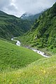
East of Sembrancher the Dranse de Bagnes and the Dranse d'Entremont to unite Dranse , the west through a deep valley at the northern foot of the Pyramid Mountain Catogne flows. At Les Valettes the Durnand flows from the Gorges du Durnand into the Dranse from the south . South of Martigny it makes a sharp bend to the north, reaches the Rhone Valley at Martigny and flows into the Rhône after a few kilometers canalised .
In the past there were always devastating floods along the Dranse. For example, the Roman ruins of Martigny are covered with thick layers of mud. The cause of the floods was often the Giétrogletscher in Val de Bagnes. When a glacier collapsed, large masses of ice fell into the valley and dammed the Dranse de Bagnes in the area of today's Lac de Mauvoisin. When the dammed lake erupted, especially in 1469, 1595, 1640 and 1818, tidal waves caused great damage along the course of the river until they poured into Lake Geneva. The construction of Lac de Mauvoisin largely protects the valley from these Tidal waves. In July 2006, a tidal wave tore the tracks of the railway line from Martigny to Orsières, so that a train derailed.
Picture gallery

Dranse de Bagnes

Inflow of the Dranse de Bagnes into the Lac de Mauvoisin with fluvial sediment deposits

Dranse d'Entremont
Dranse de Ferret


See also
Web links
Individual evidence
- ↑ a b c Geoserver of the Swiss Federal Administration ( information )
- ↑ Topographical catchment areas of Swiss waters: area outlets. In: Federal Office for the Environment FOEN. Retrieved May 30, 2019 .
- ↑ Pont de Rossettan Martigny measuring station 1991–2016 (PDF) Federal Office for the Environment FOEN
- ^ Giétroz: History of a Catastrophe. Televerbier, accessed June 7, 2020 .
- ↑ Giétro 1818 the focus of science. 200 years later. Verbier, accessed June 7, 2020 .
Rivers with a total length of more than 30 km:
Aare |
Albula |
Allaine |
Old Rhine |
Arbogne |
Areuse |
Swiss stone pine |
Birs |
Brenno |
Broye |
Calancasca |
Doubs |
Drance de Bagnes |
Thinning |
Emme |
Engelberger Aa |
Ergolz |
Glâne |
Smooth |
Glenner (Glogn) |
Hinterrhein |
Inn (En) |
Julia (Gelgia) |
Kander |
Little Emme |
Landquart |
Land water |
Langete |
Limmat |
Linth |
Lorze |
Maggia |
Mentue |
Moësa |
Muota |
Murg |
Necker |
Orbe |
Petite Glâne |
Plessur |
Rabiusa |
Reuss |
Rhine |
Rhone |
Saane |
Schüss (Suze) |
Seez |
Scythe |
Sihl |
Simme |
Sitter |
Sorne |
Suhre |
Talent |
Tamina |
Ticino (Ticino) |
Thur |
Töss |
Venoge |
Verzasca |
Vispa |
Vorderrhein |
Wigger |
Wyna