
Arve (river)
| Swiss stone pine | ||
.png) |
||
| Data | ||
| Water code | FR : V0-0200 , CH : 92 | |
| location | France , Switzerland | |
| River system | Rhône | |
| Drain over | Rhône → Mediterranean | |
| origin | near the Col de Balme in the municipality of Chamonix-Mont-Blanc 46 ° 1 ′ 18 ″ N , 6 ° 58 ′ 18 ″ E |
|
| Source height | approx. 2212 m | |
| muzzle | near Geneva in the Rhone coordinates: 46 ° 12 '4 " N , 6 ° 7' 12" E ; CH1903: 498227 / 117 484 46 ° 12 '4 " N , 6 ° 7' 12" O |
|
| Mouth height | 370 m above sea level M. | |
| Height difference | approx. 1842 m | |
| Bottom slope | approx. 17 ‰ | |
| length | approx. 108 km | |
| Catchment area | 1973 km² | |
| Discharge A Eo : 1973 km² Location: 4.1 km above the mouth |
NNQ (2011) MNQ 1935–2016 MQ 1935–2016 Mq 1935–2016 MHQ 1935–2016 HHQ (1968) |
10.3 m³ / s 46.2 m³ / s 77.3 m³ / s 39.2 l / (s km²) 102 m³ / s 840 m³ / s |
| Left tributaries | Bon Nant , Borne , Aire | |
| Right tributaries | Giffre , Menoge , Foron | |
| Big cities | Geneva | |
| Medium-sized cities | Annemasse | |
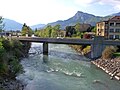
 The Arve near Annemasse , Haute-Savoie |
||
The Arve is a river in the western Alps . It rises in France , in the upper Chamonix valley near the Col de Balme and flows into Switzerland , in Geneva , as a left tributary into the Rhône . The total length of the river is around 116 kilometers, of which around 8.5 kilometers are in Switzerland. It has an average discharge of 75 m³ / s and a catchment area of 2060 km².
Places on the river
(Order in flow direction)
See also
Web links
- Paul Guichonnet: Arve. In: Historical Lexicon of Switzerland .
- Arve near SANDRE (French)
- Arve (river) on the ETHorama platform
Individual evidence
- ↑ Source geoportail.gouv.fr
- ↑ Geoserver of the Swiss Federal Administration ( information )
- ↑ Arve near SANDRE (French)
- ↑ a b Genève measuring station, Bout du Monde 1935–2016 (PDF) Federal Office for the Environment FOEN
Picture gallery

Upper course of the Arve near Montroc

The Arve in Chamonix-Mont-Blanc
The river in Cluses

Estuary in Geneva: the Rhône on the left and the Arve on the right


Rivers with a total length of more than 30 km:
Aare |
Albula |
Allaine |
Old Rhine |
Arbogne |
Areuse |
Swiss stone pine |
Birs |
Brenno |
Broye |
Calancasca |
Doubs |
Drance de Bagnes |
Thinning |
Emme |
Engelberger Aa |
Ergolz |
Glâne |
Smooth |
Glenner (Glogn) |
Hinterrhein |
Inn (En) |
Julia (Gelgia) |
Kander |
Little Emme |
Landquart |
Land water |
Langete |
Limmat |
Linth |
Lorze |
Maggia |
Mentue |
Moësa |
Muota |
Murg |
Necker |
Orbe |
Petite Glâne |
Plessur |
Rabiusa |
Reuss |
Rhine |
Rhone |
Saane |
Schüss (Suze) |
Seez |
Scythe |
Sihl |
Simme |
Sitter |
Sorne |
Suhre |
Talent |
Tamina |
Ticino (Ticino) |
Thur |
Töss |
Venoge |
Verzasca |
Vispa |
Vorderrhein |
Wigger |
Wyna