
Landquart (river)
| Landquart | ||
 The Landquart below the Klus |
||
| Data | ||
| Water code | CH : 313 | |
| location | Canton of Graubünden ; Switzerland | |
| River system | Rhine | |
| Drain over | Rhine → North Sea | |
| origin | Confluence of the Vereinabach and Verstanclabach on the Silvretta massif 46 ° 51 ′ 6 ″ N , 9 ° 57 ′ 15 ″ E |
|
| Source height | 1340 m above sea level M. | |
| muzzle | near Landquart GR in the Alpine Rhine Coordinates: 46 ° 58 ′ 8 ″ N , 9 ° 33 ′ 1 ″ E ; CH1903: 760 672 / 204137 46 ° 58 '8 " N , 9 ° 33' 1" O |
|
| Mouth height | 513 m above sea level M. | |
| Height difference | 827 m | |
| Bottom slope | 22 ‰ | |
| length | 38 km (with Vereinabach 54 km) | |
| Catchment area | 615 km² | |
| Discharge at the Felsenbach A Eo gauge : 614 km² Location: 4.9 km above the mouth |
NNQ (2010) MNQ 1926–2016 MQ 1926–2016 Mq 1926–2016 MHQ 1926–2016 HHQ (2005) |
3.17 m³ / s 15.9 m³ / s 24.3 m³ / s 39.6 l / (s km²) 39.2 m³ / s 391 m³ / s |
| Left tributaries | Arieschbach , Furnerbach , Schranggabach | |
| Right tributaries | Schlappinbach , Schanielenbach , Schraubach , Taschinasbach | |

| ||
Source and mouth of the Landquart
|
The Landquart is a 38 km (with Vereinabach 54 km) long river in the Swiss canton of Graubünden .
course
The Landquart arises on the Silvretta massif as a union of the Vereinabach and Verstanclabach , flows through the Prättigau and flows into the Alpine Rhine at the place named after it, Landquart GR in the Chur Rhine Valley . Its catchment area covers 618 km². The most important tributaries are from the right the Schanielabach , Schraubach and Taschinasbach , which arise in the Rätikon , from the left Arieschbach , Furnerbach and Schranggenbach .
history
The river is first mentioned in 1050 under the name ad fluvium langorum and around 1300 as Langwar . This name is traced back to the Celtic. Until 1870, wood was loosened on the Landquart and between 1889 and 1903 electricity works were built in Klosters , Malans , Landquart and Grüsch . The later construction of the Küblis, Klosters and Schlappin hydropower plants on behalf of Bündner Kraftwerke AG (today Repower AG ) from 1920 to 1927 was of great economic importance for the Prättigau.
Flood
The mean annual high water of the Landquart is 189.92 m³ / s. The highest annual peak ever recorded was registered in 2005 and amounted to 391 m³ / s.
The table of flood probabilities for the Landquart at the last measuring point before the confluence with the Alpine Rhine.
| Annuality (years) | 2 | 5 | 20th | 30th | 50 | 100 |
|---|---|---|---|---|---|---|
| Discharge (m³ / s) | 176 | 241 | 285 | 352 | 384 | 428 |
| Note to HQN: the number corresponding to the high water flow (HQ = H ochwasser q uantität) in m³ / s, which - repeated with the specified return period (n = number of years) - the average. | ||||||
bridges
On its way, the Landquart is spanned by over 50 bridges, the most important of which are the Landquartbrücke Klosters (trough and lifting bridge), the RhB Landquartbrücke IV (prestressed concrete truss bridge), the Sunnibergbrücke (extradosed bridge), the Landquartbrücke Dalvazza (the only Vierendeel bridge) Switzerland) and the Landquartbrücke Au (tied arch bridge). During the floods in August 2005 , a number of bridges were washed away or damaged and had to be replaced.
gallery
Near Landquart on
February 13, 1818,
looking east.
Watercolor by Hans Conrad Escher von der Linth
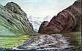
The Landquart in the Klus


Web links
- Otto Clavuot: Landquart (river). In: Historical Lexicon of Switzerland .
- Landquart hydrodata on the FOEN website
- River guide online at kajaktour.de
Individual evidence
- ↑ a b Geoserver of the Swiss Federal Administration ( information )
- ↑ Evaluations of the water network. (XLSX) (No longer available online.) FOEN , December 2013, archived from the original on June 13, 2018 ; Retrieved on August 9, 2017 (listing of Swiss rivers> 30km). Info: The archive link was inserted automatically and has not yet been checked. Please check the original and archive link according to the instructions and then remove this notice.
- ↑ Topographical catchment areas of Swiss waters: area outlets. Retrieved May 30, 2019 .
- ^ Measuring station Felsenbach 1926–2016 (PDF) Federal Office for the Environment FOEN
- ↑ limited preview in the Google book search
- ↑ Flood probabilities (annual flood), Landquart - Felsenbach. (PDF) Federal Office for the Environment FOEN, Hydrology Department, accessed on January 29, 2014 .
- ↑ Measuring point: Landquart - Felsenbach (2150), on FOEN hydrodata
Rivers with a total length of more than 30 km:
Aare |
Albula |
Allaine |
Old Rhine |
Arbogne |
Areuse |
Swiss stone pine |
Birs |
Brenno |
Broye |
Calancasca |
Doubs |
Drance de Bagnes |
Thinning |
Emme |
Engelberger Aa |
Ergolz |
Glâne |
Smooth |
Glenner (Glogn) |
Hinterrhein |
Inn (En) |
Julia (Gelgia) |
Kander |
Little Emme |
Landquart |
Land water |
Langete |
Limmat |
Linth |
Lorze |
Maggia |
Mentue |
Moësa |
Muota |
Murg |
Necker |
Orbe |
Petite Glâne |
Plessur |
Rabiusa |
Reuss |
Rhine |
Rhone |
Saane |
Schüss (Suze) |
Seez |
Scythe |
Sihl |
Simme |
Sitter |
Sorne |
Suhre |
Talent |
Tamina |
Ticino (Ticino) |
Thur |
Töss |
Venoge |
Verzasca |
Vispa |
Vorderrhein |
Wigger |
Wyna