
Kander (Aare)
| Kander | ||
.png) Course of the Kander |
||
| Data | ||
| Water code | CH : 430 | |
| location |
Bernese Oberland
|
|
| River system | Rhine | |
| Drain over | Aare → Rhine → North Sea | |
| source |
Kanderfirn 46 ° 27 ′ 53 ″ N , 7 ° 45 ′ 50 ″ E |
|
| Source height | approx. 2110 m above sea level M. | |
| muzzle |
Thunersee Coordinates: 46 ° 43 '3 " N , 7 ° 38' 38" E ; CH1903: 615 692 / 174 053 46 ° 43 '3 " N , 7 ° 38' 38" O |
|
| Mouth height | 558 m above sea level M. | |
| Height difference | approx. 1552 m | |
| Bottom slope | approx. 25 ‰ | |
| length | 61 km | |
| Catchment area | 1,094.19 km² | |
| Discharge at the gauge Hondrich A Eo : 491 km² Location: 8 km above the mouth |
NNQ (2009) MNQ 1981–2016 MQ 1981–2016 Mq 1981–2016 MHQ 1981–2016 HHQ (2005) |
3.33 m³ / s 16.2 m³ / s 20.5 m³ / s 41.8 l / (s km²) 25.5 m³ / s 273 m³ / s |
| Outflow A Eo : 1094 km² at the mouth |
MQ Mq |
42.6 m³ / s 38.9 l / (s km²) |
| Left tributaries | Alpbach , Engstlige , Simme , z. T. Glütschbach | |
| Right tributaries | Öschibach , Chiene , Suld | |
 The Kander at the entrance to the Gastern Valley |
||

| ||
Source and mouth of the Kander
|
The Kander is a river in the Bernese Oberland . It is around 47 km long and has a catchment area of 1094 km². With an average water flow of almost 43 m³ / s, it is the second largest left tributary of the Aare . The name Kander goes back to pre-Roman * kando- «white».
geography
course
The source of the Kander is fed by the Kanderfirn in the Blüemlisalp area. In its upper reaches it flows through the Gastern Valley . The section between Kandersteg and Frutigen is called Kandertal in the narrower sense. Below Frutigen, after the Kander has merged with the Engstlige , the valley is called Frutigtal . At Wimmis , the almost equally large Simme flows into the Kander. Your last short section today is artificial. It was derived during the Kander correction in 1714 through a cut in the Strättlighügel in the Thunersee . Before that, the Kander flowed into the Aare below Thun . Today there is partly the Glütschbach and the Thuner Allmend .
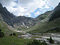
Headwaters in the Gastern Valley
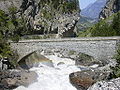
In the Klus below the Gastern Valley

At Reichenbach


Catchment area
The 1,094.19 km² catchment area of the Kander is located in the Bernese Oberland and is drained through it via the Aare and the Rhine to the North Sea.
It consists of 26.9% wooded area , 41.2% agricultural area , 2.7% settlement area and 29.3% unproductive areas.
The area distribution

The mean height of the catchment area is 1690.3 m above sea level. M. , the minimum height is 563 m above sea level. M. and the maximum height at 3676 m above sea level. M.
Tributaries
- Birggrabe ( left )
- Witefad grave ( left )
- Sack ditch ( left )
- Leitibach ( left )
- Sillerengrabe ( right )
- Fulbach ( right )
- Balmhornbach ( left )
- Geltebach ( left )
- Schwarzbach ( left )
- Alpbach ( left )
- Allmegratbach ( left )
- Öschibach ( right )
- Schattilauenebach (left)
- Stägebach ( right )
- Bunderbach ( right )
- Engstlige ( Entschlige ) ( left )
- Gunggbach ( left )
- Schlumpach ( left )
- Chiene ( right )
- Louwibach ( left )
- Richebach ( right )
- Sin ( right )
- Rossgrabe ( left )
- Chüegrabe ( left )
- Steinchenelgrabe ( left )
- Sierre ( left )
- Stadelbach ( right )
- Simme ( left )
- Kanderbächli ( left )
Dangers in water sports
The rafting on the Kander is extremely dangerous because of the many thresholds; the river is marked as impassable on the relevant hazard map. In June 2008, two Swiss Army inflatable boats capsized while attempting to descend the Kander, killing five members of the Army.
Swimming in the threshold area is also life-threatening. A man was killed in an accident in August 2018.
Web links
Individual evidence
- ↑ a b c Geoserver of the Swiss Federal Administration ( information )
- ↑ Modeled mean annual discharge. In: Topographical catchment areas of Swiss waters: sub-catchment areas 2 km². Retrieved August 12, 2017 .
- ↑ Hondrich measuring station 1981–2016 (PDF) Federal Office for the Environment FOEN
- ↑ Discharge data of the Hondrich (Kander) and Latterbach ( Simme ) gauges , increased by the discharge of the remaining catchment area below (66 km²), for which, according to the map of the Hydrological Atlas of Switzerland, an area discharge of around 25 l / s.km² is assumed.
- ↑ Topographic catchment areas of Swiss waters: Kander , Federal Office for the Environment FOEN
- ^ Right branch of the Glütschbach , the main branch of which flows into the Aare
- ^ Army accident: The search for victims continues , Swissinfo , June 13, 2008
- ^ Reichenbach im Kandertal / Wimmis: Man in the Kander fatally injured (police) Canton police Bern - Canton Bern. Retrieved August 10, 2018 .
Rivers with a total length of more than 30 km:
Aare |
Albula |
Allaine |
Old Rhine |
Arbogne |
Areuse |
Swiss stone pine |
Birs |
Brenno |
Broye |
Calancasca |
Doubs |
Drance de Bagnes |
Thinning |
Emme |
Engelberger Aa |
Ergolz |
Glâne |
Smooth |
Glenner (Glogn) |
Hinterrhein |
Inn (En) |
Julia (Gelgia) |
Kander |
Little Emme |
Landquart |
Land water |
Langete |
Limmat |
Linth |
Lorze |
Maggia |
Mentue |
Moësa |
Muota |
Murg |
Necker |
Orbe |
Petite Glâne |
Plessur |
Rabiusa |
Reuss |
Rhine |
Rhone |
Saane |
Schüss (Suze) |
Seez |
Scythe |
Sihl |
Simme |
Sitter |
Sorne |
Suhre |
Talent |
Tamina |
Ticino (Ticino) |
Thur |
Töss |
Venoge |
Verzasca |
Vispa |
Vorderrhein |
Wigger |
Wyna