
Frutigen
| Frutigen | |
|---|---|
 |
|
| State : |
|
| Canton : |
|
| Administrative district : | Frutigen-Niedersimmental |
| BFS no. : | 0563 |
| Postal code : | 3714 |
| UN / LOCODE : | CH FTN |
| Coordinates : | 616200 / 159140 |
| Height : | 800 m above sea level M. |
| Height range : | 750–2606 m above sea level M. |
| Area : | 72.28 km² |
| Residents: | 6923 (December 31, 2018) |
| Population density : | 92 inhabitants per km² |
| Mayor : | Faustus Furrer ( independent ) |
| Website: | www.frutigen.ch |
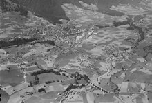
 View from the Tellenburg |
|
| Location of the municipality | |
  |
|
Frutigen is a political municipality and the capital of the Frutigen-Niedersimmental administrative district in the canton of Bern in Switzerland .
geography
The community is located in the Kander and Engstligental and stretches from the Niesen chain to the Gehrihorn . Frutigen is divided into eight Bäuerten (districts), including Achseten and Elsigbach in Engstligental.
The eastern flank of the Niesen chain is called Spissen , which comes from Spiss, a narrow piece of land. At 1000 to 1200 m above sea level M. small dwellings called are cattle forest , Ladholz , linters , scratches , Gempelen , Zwischenbäch and Ried located on sloping terraces, including lead wooded slopes to trough. The individual Spissen are accessible from the valley through forest roads, as cross connections there are only narrow, exposed mountain hiking trails through the ravine.
history
A rag ax from the Bronze Age is the first trace of residents in Frutigen. Coins and an iron ploughshare prove a Roman settlement in the Kandertal.
The first church in Frutigen was built in the 8th or 9th century, the oldest evidence of a church dates from 1228. The current church was rebuilt in 1727 after a fire. The place was first mentioned as Frutingen in 1234 .
In order to be able to settle urgent debts, Anton von Turn sold the Frutigen estate to the Schultheissen von Bern in 1400 for 6200 Florentine guilders . The Kandertal became a Bernese Landvogtei , administered by a Kastlane (Landvogt) based on the Tellenburg . The Tellenburg was built in the 12th century by Berchthold V. von Zähringen as a fortified castle and is now in ruins.
Like the rest of the Oberland , Frutigen opposed the Reformation introduced by Bern in 1528 , but had to adopt the new faith after the collapse of the Interlaken uprising. In the 18th and 19th centuries the area became a center of the reformed revival in the Bernese Oberland.
In the Helvetic Republic from 1798 to 1803, Frutigen was the capital of the Frutigen district in the canton of Oberland . After that the Kandertal was again a Bernese Oberamt and from 1831 an administrative district . In 1850, Kandergrund split off from Frutigen, which became its own municipality, to which Kandersteg also belonged until 1909 .
On August 3, 1827, a village fire destroyed 82 houses and 48 barns; apart from the church, only six houses remained intact.
From 1804 a mail car ran from Frutigen to Thun . With the expansion of the traffic routes, the Kandertal opened up to tourism and industrialization. In 1901 Frutigen was connected to Spiez by the railway; the continuation through the Lötschberg tunnel to Brig took place in 1913. In 1917 the first postbus course went to Adelboden . The north portal of the Lötschberg base tunnel, which went into operation in 2007, is located in the Frutiger area.
Since 1865, Frutigen has been the seat of a secondary school , vocational schools and a district hospital (1907) and, since 2010, the capital of the newly formed Frutigen-Niedersimmental administrative district.
During the Second World War , the Frutigen military airfield was built as part of the Reduit .
economy
Agriculture
As in most alpine regions, agriculture is mainly based on grass growing and livestock farming . Frutigen had a cattle market as early as the 14th century. Cattle breeding was an important branch of the economy, until 1866 there was a separate breed of cattle, the Frutigschlag .
The Kandertal has been the land of sheep pastures for centuries. All of the sheep's wool was processed in the valley itself, into frutig cloth , which was in great demand for traditional costumes throughout the Bern region. The peak of cloth manufacturing was in the 19th century.
According to documents from the 15th century, the cultivation of grain was insignificant. Until the 17th century there were twelve mills in the valley, but they mainly bought their grain in the lowlands. The conditions were significantly more favorable for the cultivation of potatoes and they therefore quickly found widespread use. The first potatoes were planted in 1729. For the cultivation battle at Plan Wahlen , the arable land was expanded again. Today there is almost no agriculture in Frutigen.
Tropical house Frutigen
The Lötschberg base tunnel emits around 100 liters of mountain water at around 20 ° C per second on the north side. The idea of using the mountain water for sturgeon breeding and the production of tropical fruits was implemented by the tropical house, which opened in 2009.
Industry
The 91 industrial companies employed 1096 people in 2001 and, together with the service sector (204 companies with 1476 employees), were the main employers in Frutigen. Slate mining is the oldest mining law and dates back to 1486. 1937 was the heyday of slate mining with 196 employees.
The master sack master Friedrich Schneider built the first match factory in 1850, 15 years later there were already 15 companies with a total of 332 employees. In 1972 match production was stopped. There are still two messengers from the age of matches. One of them is Bühler Holzspan , which runs a chip box museum.
Today's industry mainly relies on the manufacture of hydraulic parts. Around 700 employees are employed in the hydraulic sector. The Wandfluh AG is one of the most important companies in the valley.
Healthcare
Frutigen has a public hospital with 24-hour emergency care. It belongs to the clinic network of the FMI hospitals (Spitäler Frutigen, Meiringen, Interlaken).
Attractions
In the direction of Adelboden, at Hostalde (Hohstalden), one of the longest pedestrian suspension bridges in Europe spans the valley of the Engstligen at a height of 38 meters. The rope bridge was built in 2006, is 153 meters long and has a load capacity of 30 tons. It is privately owned but open to the public during the day. The innovation prize for mountain agriculture in the Bernese Oberland was awarded to the owners on the following grounds: "It is a completed innovative project, it creates new jobs, sells regional products and is useful for tourism". At the end of the bridge opposite the street there is a modest stop for refreshments.
politics
The municipal council and the council president assume the management tasks ( executive ). City council president is Hans Schmid (SVP). The party-political situation in the municipal council has been as follows since the election on November 19, 2017:
The community president presides over the legislature of the community, the community assembly . He mainly has representative functions and is ombudsman for the municipality. Since the election on November 19, 2017, Faustus Furrer (non-party) has been the mayor.
The voting shares of the parties at the 2015 National Council election were: SVP 43.0%, EDU 11.9%, EPP 11.1%, glp 8.9%, BDP 7.1%, SP 6.9%, FDP 5.7 %, GPS 2.6%, CVP 0.7%.
photos

Frutigen

Frutigen around 1900

Reformed village church
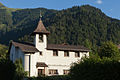
Catholic Church

left: old viaduct, right extended train line


Personalities
- Christoph Drollinger (1861–1943), German Protestant clergyman and founder of the Swiss community for early Christianity
- Berta Rosin (1874–1942), writer
- Maria Lauber (1891–1973), teacher and dialect poet
- Martin Alfred Klopfenstein (1931–2016), Reformed theologian
- Walter Donzé (* 1946), National Councilor (EPP)
- Denis Müller (* 1947), professor of theology and ethicist, University of Lausanne (home of Frutigen)
- Hansruedi Wandfluh (* 1952), National Councilor (SVP), director + board delegate Wandfluh AG, hydraulics + electronics
- Peter Grossen (* 1961), folk musician
- Albert Rösti (* 1967), National Councilor (SVP)
- Jürg Grossen (* 1969), National Councilor (glp), entrepreneur
- William White (born 1972), singer
- Emanuel Oppliger (* 1975), snowboarder
- Heinz Inniger (* 1980), snowboarder
- Christoph Kunz (* 1982), Olympic and silver medalist, Paralympic Downhill, giant slalom
- Mike Schmid (* 1984), freestyle skier
- Nadine Zumkehr (* 1985), beach volleyball player
- Simon Trummer (* 1989), racing driver
Web links
- Official website of the municipality of Frutigen
- Anne-Marie Dubler : Frutigen (community). In: Historical Lexicon of Switzerland .
literature
- Collection of Swiss legal sources. Section II: The legal sources of the Canton of Bern. Second part: rights of the landscape. Volume 2: Hermann Rennefahrt: The statutory law of the Frutigen landscape until 1798. Aarau 1937. (online)
- Isn't my valley emitts. Maria Lauber (1891–1973). Reader, published by the Frutigland Cultural Property Foundation, Zytglogge, Bern 2016.
Individual evidence
- ↑ Permanent resident population from STAT-TAB of the BfS , municipalities see also regional portraits 2020 on bfs.admin.ch, accessed on May 29, 2020
- ↑ Spissen in the eLexikon, p. 45663
- ^ Anne-Marie Dubler: Frutigen (community). In: Historical Lexicon of Switzerland .
- ↑ Frutigen Hospital
- ↑ Innovation award for the suspension bridge
- ↑ 2017 municipal elections (PDF) Municipality of Frutigen, November 19, 2017, accessed on November 19, 2017 .
- ^ Results of the municipality of Frutigen. State Chancellery of the Canton of Bern, October 18, 2015, accessed on October 30, 2016 .