
Engstligental

Launched by the Engstlige -carrying Engstligental , a tributary of the Frutigtals , is located in the Bernese Oberland ( Switzerland ).
geography
The Engstligental begins north of the Wildstrubel below the Engstligenalp and stretches almost 20 km further north, where it joins the Kandertal at Frutigen . Up to this point it loses about 800 m height. It is bordered to the west by the Niesen chain , to the east by the Lohner and its foothills and to the south by the Wildstrubel massif .
The most famous place in the valley is Adelboden , the center of which is on a terrace above the valley.
Above Adelboden, the Engstligental is a trough valley with numerous farmsteads in the scattered settlement style that is common in Frutigland , which belong to the Bäuert Boden and municipality of Adelboden. The inhabited side valleys Gilbach , Stiegelschwand and Bonderle also belong to Adelboden .
The Alps Laueli (in the Sernftal ), Bonderalp , Metschalp and Elsigenalp lie on the valley shoulders of the eastern flank at an altitude of 1800 to 2000 m , while Alp Höchst is on the western flank . There are more Alps in the side valleys.
The Chuenisbärgli is also located on the western flank of the valley and is considered to be the most difficult giant slalom slope in the Ski World Cup .
Below Adelboden the Engstlige forms a wooded ravine and the settlement is limited to a few scattered settlements. On the eastern slope, the Bäuert Hirzboden belongs to Adelboden, the Bäuert Achseten and Elsigbach to Frutigen , which are further down .
The western flank below Adelboden up to the Niesen is known as Spissen . The valley flank is divided by inhabited mountain ridges called Spissen (from Spiss, narrow piece of land) and deep rocky Bachtobel, from Adelboden to Frutigen. The uppermost part is also taken up by the Alps, which are named after the respective Spiss. At 1000–1200 m the Spissen settlements are on a sloping terrace, below which a wooded steep slope leads to the valley floor. The Spissen settlements belong to the community Frutigen, Adelboden downwards is cattle forest , Ladholz , linters , scratches , Gempelen , Zwischenbäch and Ried . The individual Spissen are accessible from the valley through forest roads, as a cross connection there are only narrow, exposed mountain paths through the ravine. In winter there is a great danger of avalanches in the ravines .
In the last few kilometers before Frutigen, the valley floor widens and the Engstlige meanders through a floodplain landscape, which has been a floodplain area of national importance since 1992 .
Development
Until the twentieth century, the Engstligental was only accessible by a footpath halfway up the east flank, which was expanded into a driveway in 1884. It was not until the 1920s that the current road was built along the Engstlige.
Slate was mined on the western flank until the twentieth century . Today, in addition to tourism, only agriculture and the wood industry are of economic importance in Engstligental.

Spitting the sneeze chain

Upper Engstligental and Engstligen Falls , seen from Adelboden
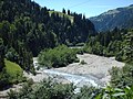
Meadow landscape on the lower Engstlige


literature
- Josy Doyon-Hofstetter : Gray gold. Story about slate mining in the Engstligental. Blaukreuz, Bern 1976, ISBN 3-85580-054-5 .
- Isn't my valley emitts. Maria Lauber (1891–1973). Reader, published by the Frutigland Cultural Property Foundation, Zytglogge, Bern 2016.
- Karl Stettler: The Frutigland . 1887, reprint 1985.
Web links
Individual evidence
- ↑ Spissen in the eLexikon, p. 45663
- ↑ Isn't my valley emitts. Maria Lauber (1891–1973). Reading book. Edited by the Frutigland Cultural Property Foundation. Zytglogge, Bern 2016.
Coordinates: 46 ° 30 ' N , 7 ° 35' E ; CH1903: 611 234 / 150667