Narrow-minded
|
Engstlige Declare, Engstligen |
||
|
Meadow landscape on the lower Engstlige |
||
| Data | ||
| Water code | CH : 428 | |
| location |
Bernese Alps
|
|
| River system | Rhine | |
| Drain over | Kander → Aare → Rhine → North Sea | |
| source | on Ammertengrat above Engstligenalp 46 ° 25 ′ 37 ″ N , 7 ° 32 ′ 31 ″ E |
|
| Source height | approx. 2312 m | |
| muzzle | below Frutigen in the Kander coordinates: 46 ° 35 ′ 52 ″ N , 7 ° 39 ′ 40 ″ E ; CH1903: 617 042 / 160740 46 ° 35 '52 " N , 7 ° 39' 40" O |
|
| Mouth height | 754 m | |
| Height difference | approx. 1558 m | |
| Bottom slope | approx. 63 ‰ | |
| length | 24.6 km | |
| Catchment area | 144.67 km² | |
| Discharge at the gauge before the A Eo mouth : 142 km² |
MQ Mq |
5.51 m³ / s 38.8 l / (s km²) |
| Communities | Adelboden , Frutigen | |
|
Engstligen a little below the Engstligen Falls |
||
The Engstlige (Bern German Entschlige ) is an approximately 25 kilometers long left tributary of the Kander in the Swiss canton of Bern .
geography
course
The Engstlige rises on the Ammertengrat above the Engstligenalp .
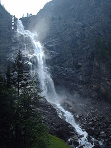
It flows north through the valley named after it and takes in several small mountain streams before it forms one of the highest waterfalls in Switzerland, the Engstligen Falls .
Above Frutigen , the Engstlige flows into the Kander in a canalised river bed . Over a length of around 25 km, it has a gradient of around 750 m.
Catchment area
The 144.67 km catchment area of the Engstlige is drained to the North Sea via the Kander, the Aare and the Rhine .
It consists of 20.9% wooded area , 45.7% agricultural area , 2.3% settlement area , 0.8% glacier / firn, 1.2% water area and 29.0% from unproductive areas.

The mean height of the catchment area is 1737 m above sea level. M. , the minimum height is 754 m above sea level. M. and the maximum height at 3229 m above sea level. M.
Tributaries
The most important tributaries are the Allenbach and Tschentenbach.
- Groppibächli ( right ). 0.7 km
- Lägerbach ( right ), 0.7 km
- Strubelbach ( right ), 2.6 km, 7.31 km²
- Stigwengbächli ( right ), 1.4 km
- Triestbächli ( right ), 0.5 km
- Wildibach ( left ), 0.8 km
- Chälibächli ( left ), 0.2 miles
- Artelebach ( right ), 1.5 km (with Vordere Artelebach 2.8 km), 3.14 km²
- Schnittegräbli I ( left ), 0.4 km
- Schnittegräbli II ( left ), 1.2 km
- Truniggräbli I ( left ), 0.3 km
- Truniggräbli II ( left ), 0.3 km
- Birggrabe ( right ), 1.4 km
- Willeschwandgrabe ( right ), 1.0 km
- Hundsgrabe ( right ), 1.3 km
- Huserweidgrabe ( right ), 0.4 km
- Helkegräbli ( left ), 0.5 km
- Ruessigrabe ( left ), 0.8 km
- Roufmattabach ( right ), 1.1 km
- Stiwidgräbli ( right ), 1.0 km
- Bollergrabe ( left ), 1.0 km
Engstligenfalls
The Engstligen Falls south of Adelboden in the Bernese Oberland are among the highest waterfalls in Switzerland and are included in the federal inventory of landscapes and natural monuments of national importance.
Engstligental
Hydrology
Discharge values
At the confluence of the Engstlige in the Kander, its modeled mean flow rate (MQ) is 5.51 m³ / s. Their discharge regime type is nival alpine and their discharge variability is 18.
The modeled monthly mean discharge (MQ) of the Engstlige in m³ / s

Flood
The Engstlige can carry a lot of water when the snow melts or after prolonged rainfall and is then raging white water . Due to the side streams from the Niesen chain, it carries a lot of debris with it, significantly more than the Kander carries, which was a major problem before the Kander correction .
freetime and recreation
tourism
Many tourists come to the Engstligental through the impressive natural beauties such as the waterfalls.
The Pochenkessel , a cataract below the confluence of the Tschentebach, is also worth seeing .
Above Frutigen, the Engstlige forms a floodplain area of national importance .
water sports
For canoeists , the Engstlige from Achseten to the Frutigen gravel works has difficulty level IV. The Pochenkessel above Achseten is not passable; the route above has a steep gradient and is very difficult.
Web links
- Engstlige Flussführer Kanuklub Bern ( Memento from November 1st, 2007 in the Internet Archive )
- Centennial flood Engstlige (1999) on feuerwehr-frutigen.ch
Individual evidence
- ↑ a b c Geoserver of the Swiss Federal Administration ( information )
- ↑ Water network in the WebGis geographic information system of the canton of Bern
- ↑ Modeled mean annual discharge. In: Topographical catchment areas of Swiss waters: area outlets. Retrieved October 31, 2015 .
- ↑ a b Topographical catchment areas of Swiss waters: Engstlige
- ↑ "Hidden behind the mean values" - the variability of the discharge regime , p. 7
- ↑ The discharge variability describes the extent of the fluctuations in the mean discharge of individual years around the long-term mean discharge value.


