
Alluvial areas of national importance
In Switzerland , alluvial areas of national importance have been protected by a federal ordinance since 1992. The aim of the regulation is to preserve the most important floodplain areas undiminished.
The regulation was drawn up on the basis of a 1982 recommendation by the Council of Europe to protect the floodplains that still exist . The underlying law is Article 18a Paragraphs 1 and 3 of the Federal Act of July 1, 1961 on Nature Conservation and Heritage Protection, the Nature and Heritage Protection Act. The Federal Office for Environmental Protection is responsible.
This ordinance currently protects 282 objects with a total of 226 km², which corresponds to around half a percent of the area of Switzerland.
Geographical classification
The floodplain areas are divided into:
- Alpine floodplains. Fall under
- Glacier forelands (52)
- alpine alluvial plains (15)
- Floodplains. A distinction is made here between
- subalpine rivers and streams from 1320 to 2020 m (21 natural, 3 corrected)
- montane rivers and streams from 560 to 1420 m (59 natural, 11 corrected)
- colline rivers from 280 to 660 m
- Mittelland (24 natural, 27 corrected)
- Southern side of the Alps and canton of Geneva (13 natural, 7 corrected)
- Central Alps (6)
- colline alluvial cone (2)
- Rivers in the moorland (5)
- Rivers in the Jura (2)
- Delta (17)
- Lakes
- Lakeside Kollin and montan (13)
- Collin and montan reservoirs (5)
Types of vegetation
The protected areas have the following types of vegetation (figures in percent of the protected area):
- Water (8%)
- Bare or sparsely vegetated floodplain sediments (3%)
- Meadow area with herbaceous vegetation (7%)
- Softwood floodplain (8%)
- Hardwood meadow (9%)
- Other forests (17%)
- Alpine floodplains (42%)
- Other areas (6%)
Examples
All or part of the floodplain areas of national importance belong
- the Bünzaue , created in 1999 during a flood, 2003
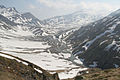
- the Engstligenalp , alpine flood plain, 2003 (no. 1352)
- the Engstligental above Frutigen, natural montane river, 1992 (No. 78)
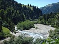
- the Gasterental , natural montane river, 1992 (No. 325)
- the Greina , alpine alluvial plain, 1992 (No. 1320)
- the Klingnau reservoir with the Gippinger Grien , Kollines reservoir bank, 1992 (No. 36)
- the Koblenz Rhine and Laufen, Rheinaue Rietheim "Chly Rhy", 1992 (No. 3)
- Morteratsch Glacier , Glacier Foreland, 2001 (No. 1238)
- the Magadino plain , Delta, 1992 (No. 169)
- the Pfynwald , Kollin River Central Alps, 1992 (No. 133)
- Rhone Glacier , Glacier Foreland, 1992 (No. 1215)
- Rosenlauigletscher , glacier foreland, 2001 (No. 1216)
- the moated castle Brugg-Stilli , meadow landscape (No. 37)
- Wildstrubel Glacier , Glacier Foreland, 2001 (No. 1129)
- Zinal Glacier , Glacier Foreland , 2001 (No. 1038)

Meadow landscape in the Gasterental
Meadow landscape on the lower Engstlige

Engstligenalp, alluvial plain
Greina, alluvial plain

Rhone glacier, glacier foreland

Rosenlauigletscher, glacier foreland

Pfynwald

Tschingelsee in the rear of the Kiental


Web links
- FOEN floodplain inventory: Descriptions of the 283 objects in the federal inventory of floodplain areas of national importance, can be downloaded per canton ZIP
- Ordinance on the protection of floodplain areas of national importance (PDF file; 507 kB)
- FOEN floodplain advice center, floodplain dossier: FOEN fact sheets
- Species protection Switzerland: floodplains
- Alluvial areas in the federal geoportal
Individual evidence
- ↑ The Bünzaue - the work of a flood. (PDF; 3.0 MB) In: ag.ch. June 2016, accessed November 13, 2018 .