
Morteratsch Glacier
| Morteratsch Glacier | ||
|---|---|---|
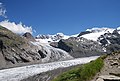
 Morteratsch Glacier (2007) with Bellavista and Piz Bernina |
||
| location | Graubünden , Switzerland | |
| Mountains | Bernina group | |
| Type | Valley glacier | |
| length | 6.4 km (2008) | |
| surface | 15.3 km² (2008, including Pers glacier) | |
| Exposure | North | |
| Altitude range | 4020 m above sea level M. - 2020 m above sea level M. (2008) | |
| width | Max. 2.8 km | |
| Ice thickness | ⌀ 75 m (2008) | |
| Ice volume | 1.2 ± 0.3 km³ (2008, including Pers glacier) | |
| Coordinates | 791 408 / 140 984 | |
|
||
| drainage | Ova da Morteratsch , Berninabach , Flaz , Inn , Danube | |
 Environment map |
||

The Morteratschgletscher ( Romansh or ) is a Alps - Glacier in the Bernina range in the canton of Grisons in Switzerland . Like almost all alpine glaciers, the Morteratsch glacier is also affected by extensive shrinkage as part of global warming ; between 1900 and 2017 it was shortened by around 2500 meters.
description
Together with the Pers glacier , the tongue of which has not reached Morteratsch since summer 2015, it is the largest glacier in the Eastern Alps with a volume of around 1.2 cubic kilometers . Since the beginning of the systematic observations in 1878, the glacier has lost 2.2 kilometers in length, it is still around 6.4 kilometers long and thus the third longest glacier in the Eastern Alps, after Pasterze and Gepatschferner in the Austrian Alps.
The traces left behind in the glacier foreland when the glacier retreats are typical of the Alps. A glacier trail explains glaciology , geomorphology and vegetation at 20 stations . Along this hiking trail there are also signs documenting the retreat of the glacier. In spring, a ski route leads from the Diavolezza over the glacier.
Origin of name
In terms of folk etymology , the name Morteratsch is explained by the Swiss legend The Jungfrau vom Morteratsch . The rich farmer's daughter Annetta and the cattle keeper Aratsch fell in love during a social event on an alp . Her parents forbade the relationship, unless Aratsch became wealthy in the near future, which is why Aratsch became a soldier abroad. The young woman died of grief before he returned. Thereupon he rode up to the alp and let his horse jump into a gorge in the glacier beyond. As a result, the girl's ghost often wandered around the alp and the herdsmen heard her complain: “Mort Aratsch” (German: Aratsch has died). One of the herding boys noticed the phenomenon, whereupon the cows gave more milk and hardly any head of cattle died. His successor, however, referred the spirit of Annetta from the Alp, whereupon he uttered a curse out of a thunderstorm: "Schmaladida saja quaist 'alp e sia pas-chüra!" (German: Cursed be this alp). After that the meadows became deserted and the alp was abandoned. Later the glacier expanded further and covered the mountain Munt Pers (German: lost mountain).
Location and surroundings
The Morteratsch Glacier is located in the canton of Graubünden , in the Maloja district and in the Upper Engadin district . Its southern edge represents the Italian-Swiss border. The glacier is located in the upper part of the Morteratsch valley, which runs from south to north and flows into the Val Bernina at Morteratsch . At the valley crossing there is a Bernina Railway station and a hotel. Morteratsch and Pers glaciers are surrounded clockwise by the three-thousand-meter peaks Munt Pers , Piz Cambrena , Piz Palü , Piz Zupò , Piz Argient , Piz Bernina ( 4049 m ), Piz Morteratsch , Piz Boval and Piz Chalchagn . The glaciers drain into the Black Sea via Ova da Morteratsch , Berninabach , Flaz , Inn and Danube .
expansion

In the upper, steep part of the glacier is very rugged and criss- crossed by crevasses and breaks . The lower, flat part forms a pronounced glacier tongue . The widest point between Piz Bernina and the Bellavista ridge is around 2.8 kilometers. The largest extension between the southernmost point, the Piz Argient, and the northern end of the glacier tongue is 6.4 kilometers. Together with the Pers Glacier, the glacier area was 15.3 square kilometers in 2008, the volume is given as 1.2 cubic kilometers, but cannot be precisely determined. The actual volume can be 0.3 cubic kilometers larger or smaller. The mean ice thickness is around 75 meters. The flow speed of the glacier can be estimated with the help of ogives . For part of the glacier it was 120 meters per year. The Morteratsch Glacier used to merge with the Pers Glacier between Isla Persa and the foot of the Munt Pers. In the hot summer of 2015, the two ice bodies parted. The glacier has left pronounced lateral moraines on the slopes to the east and west of the Morteratsch valley .
The main nutrient area of the glacier lies below the ridges between Piz Bernina in the west and Piz Argient, Piz Zupò and the Bellavista ridge in the east. The nutrient area extends down to the equilibrium line at approximately 2,600 meters.
development

In the cold periods of the Quaternary ("Ice Age"), the Morteratsch glacier fed the Inntal glacier . Towards the end of the Young Pleistocene 20,000 years ago, the ice reached its absolute peak. In the period that followed, it continued to melt. 14,000 years ago, the Morteratsch Glacier still flowed 400 meters into the Bernina Valley, where it merged with an ice stream from the Bernina Pass. At the beginning of the Holocene , around 10,000 years ago, the Morteratsch Glacier reached as far as Pontresina and was still 150 meters thick. The further decline has continued since then, but in the meantime the glaciation was already significantly less than today, the minimum being around 7,000 years ago.
The Morteratsch reached its highest level in modern times in 1857, when it had pushed up to about 100 meters from the area of today's Morteratsch station of the Rhaetian Railway . In 1878 the systematic length measurement on the Morteratsch glacier began when it was 8.6 kilometers long. Initially, the length was measured at intervals of three (1878 to 1881) and two years (1881 to 1883). Thereafter, measurements were mainly carried out annually, and since 1916 there has been a measurement every year. From the beginning of the measurements until 2015, the glacier melted by 2,649 meters; it now has a length of 6.0 kilometers. This corresponds to an average decrease of 17 meters per year. The greatest decline was observed in 1947 and 1953 with 48 meters, 1981 with 56 meters, 2003 with 77 meters and 2015 with 164 m. In only five years the glacier recorded an increase in length: in 1899 and 1988 by 2 meters, in 1912 by 5 meters, in 1985 by 8 meters and in 2004 by 10 meters. With the retreat of the glacier tongue, the end of the glacier shifted 110 meters in altitude to 2,020 meters upwards by 1991 . In 1993, the glacier level reached roughly the same level as before the Little Ice Age around 1200.


From the beginning of the measurements until 1991, the glacier lost about 2.9 square kilometers, that is 15 percent of its surface. The volume decreased by around 0.3 cubic kilometers by 1991, the average ice thickness decreased by 5 to 70 meters.
In the winter of 2008 and 2009, large caves were discovered under the glacier tongue that were created by flowing melt water. The glaciologist Felix Keller is of the opinion that the three-part glacier cave system is the largest in Switzerland. However, it is to be expected that the caves will collapse as the warming continues.
geology
The distribution of the rocks on the surface is strongly influenced by glacial processes. Dark green to brown-black gabbros and diorites as well as green serpentinites from the flanks of Piz Palü and Piz Bernina come from the head of the valley . Red and white alkali granites , blue granodiorites and diavolezza rhyolites come from the eastern flanks of the valley . The western valley flanks provide dark green to brown-black gabbrodiorites and diorites, white to green granodiorites, so-called Bernina granites, alkali granites and amphibolites . Granite, syenite , diorite and green slate are common at the valley exit .
climate
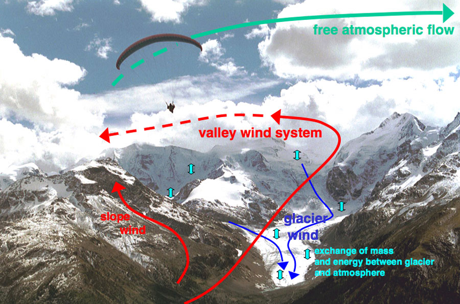
The inner, central location in the Alps results in characteristic climatic elements for the region around the Morteratsch Glacier. Basically there is a continental climate , which is characterized by hot summers, cold winters and relatively low rainfall. Because high mountain groups, in the south the Bergamasque Alps and in the northwest the Glarus Alps , shield the Engadine from the damp Atlantic and Mediterranean air masses, there is often a low level of humidity due to intense solar radiation . The measuring station on the Bernina Pass ( 2328 m ) can serve as a reference station . It is located in the eastern parallel valley and is seven kilometers away as the crow flies. From 1961 to 1990 this station registered an annual mean temperature of −0.6 ° C. An annual precipitation of 799 mm was measured at the measuring station in Pontresina ( 1803 m ) . A complex wind system arises in the valley around the Morteratsch glacier. The "normal" winds are valley winds on the ground and currents in the free earth atmosphere above the mountains. However, the glacier ice with its low temperatures creates the micro-wind system of glacier wind , which flows as downwind towards the beginning of the valley. Because valley and glacier winds flow against each other, there is an increased exchange of energy and moisture between glacier and air.
Vegetation in the glacier foreland
The documented glacier positions reveal the relationship between vegetation and glacier retreat. Already in the first year after the ice has withdrawn from an area, pioneer plants settle in the glacier foreland. In this pioneering stage, the vegetation remains for around 20 years with a degree of coverage between 1 and 10 percent. On areas that were previously free of ice, the degree of plant cover for raw soil is 15 to 75 percent. After 100 years of freedom from ice, 85 percent of the ground is covered. Between 40 and 60 years without ice, more than 50 percent land cover develops. The degree is significantly lower if the surfaces are free of ice for a shorter period of time. After 20 years, soil with vegetation has formed on less than 20 percent of the areas and after ten years on less than ten percent.
The first plants to settle in the debris of the moraines developed different strategies to adapt to the conditions. Rubble wanderers like the shield dock and the round-leaved hellerkraut penetrate the rubble with long crawling shoots. Rubble crawlers like the alpine toadflax cover the rubble with leafy shoots. With the help of upright shoots, the rubble stretcher can get over the rubble like alpine sourlings . Coverings that take root on the rubble are covered by debris such as the white silver arum or the opposed saxifrage . Flowing debris is held up by dense roots or tap roots from glacier buttercups , moss saxifrage , cushion sedge and blue-lime grass , the so-called debris damming .

Vegetation cover towards the glacier tongue

Overview of vegetation progress

Advanced vegetation

Vegetation on a lake on the Boval climb


In the first year after the ice retreat, Fleischer's willowherb , shield dock, German tamarisk , pale clover , alpine sourling and ripe willow settle on the fresh areas . Colonization with musk yarrow , clove-leaved hawkweed and moss saxifrage begins until the third year . Cobweb houseleek and common horn clover follow in the eleventh year . The fireweed is most common in the run-up to the glacier. Other early pioneer settlers are Alpine bluegrass , single-flowered hornwort , sedum saxifrage and creeping clove root .
Some plants in the Morteratschtal have a significantly lower maximum age than in the rest of the western Alpine region. This means that colonization with these plants started more slowly than in the comparison areas. Alpine helmets , Alpine toadflax and big nettles show a delay of ten years . Musk yarrow and Scheuchzer's bellflower begin to grow after a delay of 13 and 16 years . The gold cinquefoil has another two years difference . The beach plantain is 20 years late, the creeping avens 27 years late . The biggest delays are the pebble clove at 33 and the western alpine clover at 42 .
Besides the mentioned species are found in Morteratsch after the retreat of the glacier several other species of the following plant families : Asteraceae , Brassicaceae , Bellflower Family , Pink family , Crassulaceae , legumes , Gentian family , Onagraceae , Buckwheat Family , Rose Family , Saxifragaceae and Figworts .
The entrance to the Morteratsch valley belongs to the subalpine level, where the tree line is at 2,300 meters. The European larch and Swiss stone pine have the largest share of the trees , the tree line is at 2,350 meters. The larch settles faster than the Swiss stone pine. After ten years without ice there is larch growth, which after another ten years reaches a height of two meters. While the larches are five meters high 30 years after the ice retreat, only then does the Swiss stone pine begin to grow. At the age of ten, these reach a height of two meters. Larches at the age of 30 are over six meters tall. The height growth stagnates in larches between the ages of 40 and 60 years at eight meters, in Swiss stone pines between 20 and 40 years and just over four meters. In areas that have been ice-free for over 100 years, however, the trees are roughly the same height.
Alpinism

In spring, the Morteratsch glacier is prepared for skiers. From the mountain station of the Diavolezza mountain railway, a demanding, marked ski route that has been checked for safety leads over the Pers glacier down to the Morteratsch inn at the entrance to the valley. A difference in altitude of 1100 meters is overcome on the ten-kilometer descent. The descent takes one to two hours. The glacier is also used for ski tours in winter, for example with the descent from Piz Palü.
Mountaineers climb the glacier in summer on various tours, such as the descent from the Diavolezza over the Pers glacier. This guided tour is very popular with school classes. One route to Piz Zupò leads over the Morteratsch Glacier. When crossing the Piz Bernina from the north, the route leads over the Marco-e-Rosa hut on the upper part of the Morteratsch glacier, the Isla Persa and the Pers glacier to the Diavolezza. Due to the easy accessibility through the Morteratschtal and the nearby Bovalhütte, the glacier is also used for alpine ice formation. At the entrance of the Morteratschtal there is a climbing garden suitable for children with routes of all difficulty levels up to VII . A climbing garden has also been set up at the Bovalhütte.
photos
Confluence with the Pers glacier

View of the glacier from the end of the tongue in 2000 seven years later

In the area of confluence with the Pers glacier

In the glacier cave in October 2009

Image of the glacier in April 2015 with markings at the place where it ended in 2010

The Morteratsch Glacier on Piz Bernina in June 2019 from an altitude of 4000 m


literature
- Max Maisch, Conradin A. Burga, Peter Fitze: Lively Glacier Foreland - Guide and accompanying book for the Morteratsch glacier nature trail. Engadin-Press AG, Samedan 1999.
Web links
- Research Institute for Hydraulic Engineering, Hydrology and Glaciology (VAW) of the ETH Zurich (Ed.): Morteratschgletscher. In: Swiss Glacier Measurement Network. ( ethz.ch , also as PDF ).
- The Morteratsch Glacier on Glaciers online
- Research project Morteratsch Glacier of the University of Utrecht (IMAU)
- Morteratsch Glacier - then and now (PDF; 4.8 MiB)
- Study by the University of Graz on glaciers in the Bernina and the Ötztal Alps ( Memento from February 17, 2009 in the Internet Archive )
- Oldest photo of the Morteratsch Glacier from 1867 in the picture archive of the ETH Library
- Film contribution by Swiss TV (SF) about the ice caves in the Morteratsch Glacier ( Switzerland currently from December 23, 2009)
- Film contribution by Swiss television (SF) about the effects of climate change on the Morteratsch Glacier (Switzerland currently from September 15, 2010)
Remarks
- ↑ The information provided by the Pontresina station on precipitation is more suitable than that of the Bernina Pass station. It is located at the upper end of the Poschiavo , a valley that opens to the south. Also in the further course there are no such distinctive orographic obstacles in the extension of the Poschiavo to the south . This allows the humid air masses from the south to flow relatively unhindered onto the Bernina Pass. To the west of it, directly towards the Morteratsch Glacier, the heights of the Bergamasque Alps are increasingly holding back moist air masses.
swell
literature
- Max Maisch, Conradin A. Burga, Peter Fitze: Lively Glacier Foreland - Guide and accompanying book for the Morteratsch glacier nature trail. Engadin-Press AG, Samedan 1993.
Web links
- Morteratsch Glacier on the ETHorama platform
Individual evidence
- ↑ How quickly the Swiss glaciers are melting. Neue Zürcher Zeitung, January 31, 2019, accessed on January 31, 2019 (Swiss Standard German).
- ↑ a b Radio Südostschweiz from September 23, 2015: Our glaciers are starving ( Memento from January 31, 2016 in the Internet Archive )
- ↑ The Virgin from Morteratsch. (PDF) kiknet.ch, archived from the original on March 2, 2016 ; accessed on July 31, 2015 .
- ↑ The Virgin from Morteratsch. Mutabor Märchenstiftung, accessed on March 24, 2017 .
- ↑ Data obtained from email contact with Andreas Bauder (Research Institute for Hydraulic Engineering, Hydrology and Glaciology at ETH Zurich , VAW).
- ↑ Jürg Alean, Michael Hambrey: Teaching and learning on the Morteratsch glacier. swisseduc.ch, 2007, accessed on August 6, 2009 .
- ↑ Max Maisch: Lively Glacier Foreland . P. 35.
- ↑ Max Maisch: Lively Glacier Foreland . P. 11.
- ↑ Hilmar Schmundt: Puzzle from the ice . In: Der Spiegel . No. 21 , 2005, p. 166 ( online [accessed November 13, 2014]).
- ↑ Max Maisch: Lively Glacier Foreland . P. 12.
- ↑ a b Research Institute for Hydraulic Engineering, Hydrology and Glaciology (VAW) of the ETH Zurich (ed.): Vadret da Morteratsch - Measurements of the change in length between 1878 and 2008. In: Schweizerisches Gletschermessnetz. ( ethz.ch , data on length changes , also as PDF , accessed on May 18, 2009).
- ↑ Max Maisch: Lively Glacier Foreland . P. 20.
- ↑ The glaciers - Bernina and Ötztal Alps in comparison. Institute for Geography and Spatial Research, Karl-Franzens-University Graz, 1999, archived from the original on February 17, 2009 ; Retrieved May 19, 2009 .
- ↑ Andrea Badruit: Largest ice cream parlor in Switzerland. (PDF; 640 kB) Bündner Tagblatt, February 5, 2009, accessed on May 19, 2009 .
- ↑ Max Maisch: Lively Glacier Foreland . P. 28.
- ↑ Federal Office for Meteorology and Climatology Meteo Switzerland: The climate of Switzerland - A brief overview. 2008, archived from the original on April 8, 2009 ; Retrieved May 19, 2009 .
- ↑ Federal Office for Meteorology and Climatology Meteo Switzerland: Mean temperatures Bernina Pass: normal period 1961 to 1990. (PDF) 2009, archived from the original on April 9, 2011 ; Retrieved May 20, 2009 .
- ↑ Federal Office for Meteorology and Climatology Meteo Switzerland: Annual precipitation Pontresina: normal period 1961 to 1990. (PDF) 2009, archived from the original on April 29, 2011 ; Retrieved May 20, 2009 .
- ↑ Wind systems in the Morteratschtal. Institute for Marine and Atmospheric Research, Utrecht University, accessed on May 20, 2009 .
- ↑ Jürg Alean, Michael Hambrey: Degree of cover of the vegetation. swisseduc.ch, 2007, accessed on May 19, 2009 .
- ↑ Max Maisch: Lively Glacier Foreland . P. 32.
- ↑ Max Maisch: Lively Glacier Foreland . P. 40.
- ↑ Andrea Münch, Ruth Schwarz: Dendrochronology of herbs and bushes in the run-up to the Morteratsch glacier. (PDF; 506 kB) BAUHINIA - Journal of the Basel Botanical Society, 2007, accessed on February 16, 2017 .
- ↑ Jürg Alean, Michael Hambrey: Maximum tree heights in the glacier foreland . swisseduc.ch, 2007, accessed on May 19, 2009 .
- ↑ Morteratsch. In: Felsklettern.ch ; Climbing garden Morteratsch KIBE '96 ( Memento from October 30, 2007 in the Internet Archive ). Retrieved August 6, 2009.
- ↑ Boval climbing garden . Retrieved August 6, 2009