
Piz Bernina
| Piz Bernina | ||
|---|---|---|
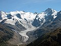
 Piz Bernina from the Diavolezza , on the far right the Biancograt |
||
| height | 4048.6 m above sea level M. | |
| location | Graubünden , Switzerland | |
| Mountains | Bernina group | |
| Dominance | 138 km → Finsteraarhorn | |
| Notch height | 2234 m ↓ Malojapass | |
| Coordinates | 789 947 / 139751 | |
|
||
| First ascent | September 13, 1850 by Johann Wilhelm Coaz , Jon and Lorenz Ragut Tscharner | |
| Normal way | Spallagrat from Rif. Marco e Rosa (II) | |

The Piz Bernina is the only four-thousand-meter peak in the Eastern Alps and the highest mountain in the canton of Graubünden in Switzerland . The national map of Switzerland gives its height at 4049 m above sea level. M. at. Like its neighbors Piz Palü , Piz Roseg and Bellavista, Piz Bernina belongs to the Bernina group or simply the Bernina. The border between Italy and Switzerland runs almost 200 meters south of the summit . Due to its dominance, the Piz Bernina offers an exceptional view in all directions and is even visible from countless peaks. Because of the conspicuous Bianco ridge, it is also easy to identify. The farthest visible point ( 43 ° 45 ′ 49.8 ″ N , 12 ° 16 ′ 30.8 ″ E ) from Piz Bernina is on a ridge between the Italian regions of Emilia-Romagna and Tuscany , 41 km southwest of Rimini and is 349 km away.
geography

The mountain consists of three peaks , the middle of which is the highest. The southern summit Spalla (La Spedla, 4020 m ) is slightly lower and hardly separated from the main summit . The state border runs over its southwest and southeast ridge. The main summit is - even if this is often presented differently by the Italian side - entirely on Swiss territory. To the north of the main summit, beyond the striking Bernina Pass, is the northern summit ( Piz Bianco or Rhaeto-Romanic ). The north summit is the end point of the firnigen part of the north ridge (Biancograt, Romanesque: Crast 'Alva ). The latter is often considered to be the most beautiful ice ridge in the Alps.
The Piz Bernina is connected in the southwest via the Scerscen-Scharte with the 3971 m high Piz Scerscen . In the southeast it is separated from the Crast 'Agüzza ( 3854 m ) by the glaciated Fuorcla Crast' Agüzza ( 3591 m ) . In the north, the Biancograt ends in Fuorcla Prievlusa ( 3430 m ), behind which the ridge rises again to Piz Morteratsch ( 3751 m ).
On the north side of the mountain are the Morteratsch and Tschierva glaciers, two large glaciers, both of which drain to the Danube via Flaz and Inn . The Piz Bernina is the highest point in the catchment area of the Danube. On the south side is the Vedretta di Scerscen Superiore , another larger glacier. This drains through the Val Scerscen via Lanterna and Mallero to the Adda .
tourism
Alpine bases
Switzerland

Accommodation on the Swiss side are the two Alpine Club huts of the SAC Chamanna da Tschierva ( 2583 m ) in the Roseg Valley and Chamanna da Boval ( 2495 m ) in the Morteratschtal . The Chamanna da Tschierva is the starting point for the ascent of the Bernina over the Biancograt .
Italy
On the Italian side, the usual ascent is via the Rifugio Carate Brianza ( 2662 m slm ) and the Rifugio Marinelli ( 2813 m slm ). Furthermore, the Spallagrats is there above the upper Scerscen glacier at the foot of a outworked, accessible only with glacier equipment base on 3609 m slm , the Rifugio Marco e Rosa De Marchi of CAI .
Valley locations
Valley locations are Pontresina - on the north side - and Chiesa in Valmalenco and Lanzada - on the south side.
Origin of the name
The name originally only suited the area near the pass hostel ; It was transferred to the highest peak in the area by the first climber Johann Wilhelm Coaz . It is assumed that the owner of the hostel, or the older alp, is called Bernin, corresponding to the Italian personal name Bernini .
First ascent

In 1850, the surveyor Johann Wilhelm Coaz (1822–1918) from S-chanf , a surveyor in Dufour's service from the Swiss Office for Topography , was commissioned to measure the then nameless summit. On September 13, 1850, Coaz began the ascent from the «Bernina Häuser» inn, together with the two measurement assistants and guides Jon and Lorenz Ragut Tscharner from Domleschg . They were equipped with nailed shoes, a hemp rope, headscarves to protect them from the sun and long sticks to probe cracks. Over the Morteratsch glacier they reached its labyrinth , known as the crevice -rich part, which they crossed with great difficulty. Via the south side they reached the east ridge, probably above the Sass dal Pos (3256 m). At 6 p.m. all three reached the summit, planted the Swiss flag and placed a bottle with a few Graubünden coins and a slip of paper with their names in a recess.
The descent was made with great effort on the same route. According to Coaz's route description, the benevolent moon took pity on her , so that at 2 a.m., 20 hours after setting off, she arrived safely back at the Bernina Inn.
Routes
The easiest route leads from the Rifugio Marco e Rosa over the Spallagrat to the Bernina summit (firn and rock ridge, difficulties in the rock up to UIAA II). Another possibility is the much-traveled Bianco ridge, a combined climbing route over the striking snow edge of the north ridge (ice up to 50 °, at the transition to the UIAA III summit). Much more demanding routes lead through the rocky west flank. The best known is probably the one that was committed by Patrick Gabarrou and Tobias Heymann on August 17, 1993 for the first time. This route is rated SS +. In addition, an extraordinarily long ridge route with a level of difficulty ZS + leads from the Porta da Roseg to the Spalla. This celebrated Paul Güssfeldt , Emile Rey and JB Aymonod on 22 September 1887 as the first.
panorama

photos

Bianco ridge

Northern flank with Morteratsch Glacier

View from the west (Tschiervahütte)
Bernina massif and Morteratsch glacier
Piz Bernina from Piz Morteratsch

View from Diavolezza


literature
- Anton Mayr: Ascent of Piz Bernina (4052 m) avoiding the main ridge with reference to the frequent accidents in the Alps. In: Der Alpenfreund. Illustrated tourist magazine for the Alpine region , issue 5/1896, (VI. Year), pp. 45–50. (Online at ANNO ). -: Ascent (...) (1st continuation). In: Der Alpenfreund. Illustrated tourist magazine for the Alpine region , issue 6/1896, (VI. Year), pp. 57–60. (Online at ANNO ). -: Ascent (...) (2nd continuation). In: Der Alpenfreund. Illustrated tourist magazine for the Alpine region , issue 7/1896, (VI. Year), pp. 71–74. (Online at ANNO ). -: Ascent (...) (3rd continuation, end). In: Der Alpenfreund. Illustrated tourist magazine for the Alpine region , issue 8/1896, (VI. Year), pp. 85–87. (Online at ANNO ).
- Peter Donatsch (Red.): People at Piz Bernina - yesterday, today, tomorrow. 100 years of the Bernina Section, SAC . Verlag Bündner Monatsblatt, Chur 1990, ISBN 3-905241-10-2 .
- Daniel Anker (ed.), Robert Bösch (photo): Piz Bernina - King of the Eastern Alps . Mountain Monographs, Volume 4. AS Verlag & Buchkonzept AG, Zurich 1999, ISBN 3-905111-45-4 .
- Walther Flaig: Bernina - Ballroom of the Alps . Bergverlag Rother , Munich 1962.
- Helmut Dumler, Willi P. Burkhardt: Four-thousanders in the Alps . 13th updated edition. Bergverlag Rother, Munich (Ottobrunn) 2007, ISBN 978-3-7633-7427-4 .
- Martin Bundi: Bernina, Piz (GR). In: Historical Lexicon of Switzerland .
Web links
- Piz Bernina at 4000m - the four-thousanders of the Alps
- Piz Bernina on the ETHorama platform
- Calculated 360 ° panorama from Piz Bernina
- Original description of the first ascent
Individual evidence
- ↑ Piz Bernina on Peakbagger.com (English)
- ↑ Calculated 360 ° panorama ( U. Deuschle ; information ) from Piz Bernina
- ↑ Andrea Schorta: How the mountain got its name . Small Rhaetian name book with two and a half thousand geographical names of Graubünden. Terra Grischuna Verlag, Chur and Bottmingen / Basel 1988, ISBN 3-7298-1047-2 , p. 67 .
- ↑ Pioneers of alpinism in Switzerland ( Memento of October 30, 2008 in the Internet Archive )
- ↑ Terra Grischuna , edition 2/2010, p. 32.