Tschiervagletscher
| Tschiervagletscher | ||
|---|---|---|
|
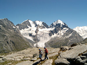
Tschierva glacier from the north-west, with Piz Bernina , Piz Scerscen and Piz Roseg |
||
| location | Canton of Graubünden , Switzerland | |
| Mountains | Bernina group | |
| Type | Valley glacier | |
| length | 3.95 km (2012) | |
| surface | 7.1 km² (1991) | |
| Exposure | northwest | |
| Altitude range | 4000 m above sea level M. - 2340 m above sea level M. (2005) | |
| Ice volume | 0.31 ± 0.08 km³ (1991) | |
| Coordinates | 787 993 / 140 554 | |
|
|
||
| drainage | Rosegbach , Flaz , Inn | |
The Tschiervagletscher ( Rhaeto-Romanic in the idiom Puter , German literally Hirschkuhgletscher ) is a valley glacier in the Bernina group in the canton of Graubünden . In 2012 the length was about four kilometers; in 1991 a value of 7.1 km² was determined.
Location and surroundings
The upper part of the glacier is divided in two by the cliff edge of Piz Scerscen ( 3971 m above sea level ) and Piz Umur . The eastern part has its origin on the steep western flank of Piz Bernina , while the western part starts in the deep cirque between Piz Roseg and Piz Scerscen at around 3300 m . The Tschierva glacier flows northwest along the southwest flank of Piz Morteratsch into Val Roseg . In 2005 the glacier tongue ended at an altitude of 2340 m above sea level. M. . The meltwater emerging at this point flows over the Rosegbach ( Ova da Roseg ) and the Flaz to the Inn .
The Tschiervahütte ( Chamanna da Tschierva ) of the Swiss Alpine Club is located above the north-eastern lateral moraine of the glacier at an altitude of 2583 m above sea level. M. It is the starting point for popular alpine tours in the Bernina massif, such as the ascent of Piz Roseg and Piz Bernina via its north ridge, the Bianco ridge .
Historical development
During the Little Ice Age , the growth of the Tschierva glacier reached its modern peak around 1860, and the Tschierva glacier in Val Roseg merged with the Roseg glacier until 1944 . Behind the former central moraine, the now orographically left lateral moraine of the Tschiervagletscher, a lake subsequently formed, which is shown on the Swiss national map as Lej da Vadret .
In August 1954, the lake's water level rose rapidly by 85 centimeters due to melting snow and heavy rainfall. As a result, there was severe erosion at the lake outlet and the additional water masses flowed away quickly until the water level had sunk back to roughly the original level. The major flood damage in the Upper Engadine during the summer of 1954 was partly caused by this.
Web links
- Tschiervagletscher on the ETHorama platform
- Map section at map.geo.admin.ch
- Images and comparison maps on glaciers-online.net
Individual evidence
- ↑ a b Research Institute for Hydraulic Engineering, Hydrology and Glaciology (VAW) of the ETH Zurich (ed.): Tschiervagletscher. In: Swiss Glacier Measurement Network. ( ethz.ch , also as PDF , accessed on October 23, 2014).
- ↑ a b c Daniel Farinotti, Matthias Huss, Andreas Bauder, Martin Funk: An estimate of the glacier ice volume in the Swiss Alps. In: Global and Planetary Change. 68: 225-231, 2009 ( online ; PDF; 756 kB).
- ↑ a b WGMS: Fluctuations of Glaciers Database. World Glacier Monitoring Service, Zurich 2013 ( DOI: 10.5904 / wgms-fog-2013-11 ), accessed on December 11, 2013
- ^ Research institute for hydraulic engineering, hydrology and glaciology (VAW) of the ETH Zurich : Vadret dd Tschierva, Vadret da Roseg. In: Glacier Natural Hazards. ( ethz.ch ( page no longer available ), also as a PDF ( page no longer available )).


