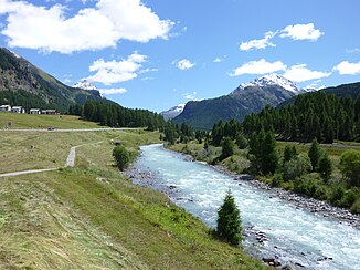
Flaz
| Flaz | ||
|
Flaz at Punt Muragl |
||
| Data | ||
| Water code | CH : 8897 | |
| location | Upper Engadin , Graubünden , Switzerland | |
| River system | Danube | |
| Drain over | Inn → Danube → Black Sea | |
| source | Confluence of the Berninabach and Rosegbach rivers 46 ° 29 ′ 33 ″ N , 9 ° 54 ′ 0 ″ E |
|
| Source height | 1756 m above sea level M. | |
| muzzle | near Samedan in the Inn Coordinates: 46 ° 32 '36 " N , 9 ° 53' 32" E ; CH1903: 788 167 / 157 618 46 ° 32 '36 " N , 9 ° 53' 32" O |
|
| Mouth height | 1698 m | |
| Height difference | 58 m | |
| Bottom slope | approx. 8.9 ‰ | |
| length | approx. 6.5 km (with Berninabach approx. 21.5 km) | |
| Catchment area | 193.13 km² | |
| Outflow A Eo : 193.13 km² |
MQ Mq |
8.11 m³ / s 42 l / (s km²) |
| Main river route of the Danube system | ||
The Flaz ( Rhaeto-Romanic in the idiom Puter , more rarely Rhaeto-Romanic = Flazbach ) is a river in the Upper Engadin between Pontresina and Samedan . According to its name, it begins below Pontresina at the confluence of the Berninabach (Ova da Bernina) and Rosegbach (Ova da Roseg) and flows into the Inn at Samedan .
At the confluence, the water flow of the Flaz exceeds that of the Inn (7.9 m³ / s compared to 6.8 m³ / s), so that hydrologically it represents the main river of the Inn system and even - in view of the slightly higher average compared to the Danube Water flow of the Inn - that of the Danube system.
The Flaz river system is characterized by the lack of a dominant main flow path. At the confluence with the Rosegbach the Berninabach is still clearly recognizable as the larger brook (catchment area Roseg: 67 km², catchment area Bernina: 110.5 km², but with a slightly higher discharge in Val Roseg), this is at the confluence of the 5.8 River kilometers above the mouth of the Ova da Morteratsch (with the largest glacier in the Inn area) is hardly the case. Here in summer the Ova da Morteratsch is larger because of the glacier meltwater, otherwise the Ova da Bernina, whose catchment area is around 20% larger.
A little above the Val da Fain flows into another almost equal tributary. The two longest source branches of the Bernina stream arise from the glaciers on the northern slope of the Piz d 'Arlas in the east of the Bernina main ridge . A spätwürmeiszeitliche moraine these glaciers also dammed the upper Berninatal and finally to Puschlav effluent Lago Bianco formed. Contrary to the general slope of the valley, the lake is not part of the Flaz river basin, not even before the construction of the dam. It is also thanks to the effect of Ice Age glaciers that no visually clear main valley was created. Ova da Morteratsch and Ova da Roseg form the dominant valley lines, whereas the Bernina stream plunges down towards them in valley steps : at the RhB station Morteratsch with waterfalls, at Pontresina in a gorge .
In 2004 the Flaz was relocated from Samedan to a new bed on the east side of the Samedan airfield for flood protection reasons . The river has been two kilometers longer since then. The old river bed Flaz Vegl to the west of the golf course has become a harmless stream after being renatured . Due to the estuary, which is now further down the valley, the dominance of the Flaz compared to the Inn, whose catchment area is now almost 1% larger (before the estuary was relocated, the Flaz carried 7.63 m² / s and the Inn 6.18 m³ / s). The greater water flow of the Flaz results from the significantly higher annual mean runoff in its catchment area.
Web links
Individual evidence
- ↑ a b c Geoserver of the Swiss Federal Administration ( information )
- ↑ a b Topographical catchment areas of Swiss waters: sub-catchment areas 2 km². Retrieved June 10, 2019 .
- ^ Hydrological Atlas of Switzerland of the Federal Office for the Environment FOEN, Table_54

