
Bernina group
| Bernina group | |
|---|---|
.png) |
|
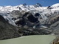
 Bernina group from the northeast with Piz Palü, Bellavista, Piz Zupò, Crast'Agüzza, Piz Bernina and Piz Morteratsch |
|
| Highest peak | Piz Bernina ( 4049 m above sea level ) |
| location | Engadin , Graubünden , Switzerland / Veltlin , Province of Sondrio , Italy |
| Classification according to |
AVE : Eastern part of 66 SOIUSA : 15.III |
| Coordinates , ( CH ) | 46 ° 23 ' N , 9 ° 55' O ( 790 026 / 139 939 ) |
The Bernina Group or mostly just the Bernina is a mountain group in the central Eastern Alps . Your highest peak, 4049 m above sea level. M. high Piz Bernina , is the only four-thousand-meter peak in the Eastern Alps .
Location and limitation
The Bernina extends south of the Upper Engadine from the Murettopass in the west to the Bernina Pass in the east. Its main ridge is part of the main Alpine ridge and watershed between Inn and Danube in the north and Adda and Po in the south. The border between Switzerland and Italy runs over it in the western and central section . Its eastern part is also Swiss on the south side ( Puschlav ). The Southern Bergell mountains and the group of Monte Disgrazia not part of the Bernina in the true sense. In the interest of a certain geographical standardization, however, all three mountain groups are sometimes combined, as is the case in the Alpine Club division of the Eastern Alps under the name Bernina Alps.
The shelters of the total area are there listed.
Surname
The origin of the name is still unclear today. Barnyna was a field name mentioned in 1429, as was Pernina (mentioned in 1538). The meaning of the name is not known. A personal name Bernin, as Bernini in northern Italy, was probably the namesake of the Bernina Suot settlement and the neighboring alp in the Val Minor .
construction
The Bernina essentially consists of three T-shaped mountain ranges with peaks consistently over 3900 m . The middle section of the "T" is the Piz Bernina itself, together with lower peaks adjacent to the north such as Piz Morteratsch and Piz Boval . The transverse bar of the "T" is mainly formed by Bellavista and Piz Palü to the east, and mainly by Piz Roseg to the west . To the east of Piz Bernina, Val Morteratsch stretches to the north, to the west - parallel to it - Val Roseg . Beyond this central part of the Bernina, the peaks are consistently lower at around 3,300 - 3,500 m . This applies initially to the so-called Sella group at the end of the Val Roseg, but also to the peaks that adjoin further to the west at the end of the Fex and Fedoz valleys. On the south side, the Bernina breaks off in several steps without a clear geographical structure and only weakly divided by the ravine-like valleys of Scerscen and Fellaria against the Valmalenco , a side valley of the Valtellina .
geology
The Bernina is part of a sub-eastern Alpine blanket, a clod of crystalline rock that was pushed up from more southern areas. To the northwest of it and on its southern edge, the deeper Penninic, overturned by the Eastern Alps, is visible. To the west it is joined by the Bergell Alps, which consist of granite that has intruded into the Penninic . Geologically speaking, the Bernina thus forms the western end of the Eastern Alps. Further to the west, the geological structures of the Bernina only find a kind of continuation in the Dent Blanche Nappe of the central Valais Alps .
glacier
Like almost all alpine glaciers, the glaciers of the Bernina group are also affected by extensive shrinkage as part of global warming . All of the group's glaciers have lost significant length and mass in the last few decades, especially since around 1990. For example, the Morteratsch Glacier shortened by around 2500 meters between 1900 and 2017. In Val Morteratsch, the tongues of the Morteratsch and Pers glaciers flow from the largest firn basin in the area, and their tongues joined below the Isla Pers until 2015. The upper part of the Val Roseg is filled by the Tschierva and Roseg glaciers . Both valleys drain on the north side over the Flaz into the Inn . To the east lies Palü glacier , in the south of the glaciers of Scerscen and Fellaria.
Panoramas showing the glacier retreat between 2013 and 2019


Important mountains over 3500 m
- Piz Bernina , 4049 m
- Piz Zupò , 3996 m
- Piz Scerscen , 3971 m
- Piz Argient , 3945 m
- Piz Roseg , 3937 m
- Bellavista , 3922 m
- Piz Palü , 3900 m
- Crast 'Agüzza , 3854 m
- Piz Morteratsch , 3751 m
- Piz Cambrena , 3603 m
- Piz Glüschaint , 3594 m
- La Sella , 3584 m
- Piz Tschierva , 3546 m
gallery
Sellagrat with Roseggletscher

Piz Bernina , Piz Scerscen and Piz Roseg from Fuorcla Surlej

Piz Palü and Bellavista from Diavolezza

26k * 9k panorama 2013

26 * 6k Panorma 2019, Persgletscher has lost 25-50m thickness since 2013!
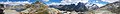
Fuorcla Surlej, panorama with Bernina group, July 2020

Fuorcla Surlej, view of the Bernina range, July 2020


Web links
- Bernina group on the ETHorama platform
- Video impressions of the Bernina group
Individual evidence
- ↑ Martin Bundi : Piz Bernina. In: Historical Lexicon of Switzerland . July 10, 2010 , accessed June 6, 2019 .
- ↑ The glacier initiative wants to anchor the CO2 reduction in the constitution - the climate strikers are doing this too slowly. Neue Zürcher Zeitung, January 31, 2019, accessed on January 31, 2019 (Swiss Standard German).
