
Palü Glacier
| Palü Glacier | ||
|---|---|---|
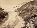
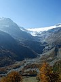
 Palü Glacier in August 2009 |
||
| location | Canton of Graubünden , Switzerland | |
| Mountains | Bernina group | |
| Type | Mountain glacier | |
| length | 3.6 km (2007) | |
| surface | 6.47 km² (2007) | |
| Exposure | east | |
| Altitude range | 3870 m above sea level M. - 2640 m above sea level M. (2004) | |
| Coordinates | 795 540 / 137844 | |
|
||
| drainage | Lago Palü , Cavagliasch , Poschiavino , Adda , Po | |

The Palü glacier (the Lombard dialect Valposchiavo Vadret da Palu ) is a glacier in the Bernina Range of the Swiss Alps in the canton of Grisons .
description
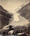
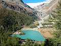
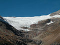
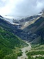
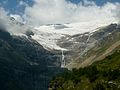
The glacier reached its last high point around 1860, when its tongue reached far into the level of Alp Palü and threatened to reach the Palüsee. As early as the first half of the 20th century, the glacier withdrew from the level of Alp Palü. In the 1970s he paused briefly over the first rock threshold above the Alp. Since the beginning of the 1990s the melting process accelerated dramatically and the tongue of the glacier retreated further and further over the rocks, currently (2007) the tongue is at approx. 2600 m above sea level. At the highest level it reached up to about 1940 m above sea level. M. down. From the year 2000 a new glacial lake formed at the foot of the glacier on the first rock terrace above Alp Palü.
The meltwater from the glacier flows as Aqua da Palü into the Palüsee , where the largest part is collected by the Rätia Energie power plants .
1867
1873

circa 1910

circa 1910
2003
2003

2005
2007
2008

2009
2011


Web links
- Palü glacier on the platform ETHorama
- Images and graphics for changing the length on Glaciers-online.net
- Research institute for hydraulic engineering, hydrology and glaciology (VAW) of the ETH Zurich (ed.): Palügletscher. In: Swiss Glacier Measurement Network. ( ethz.ch , also as PDF ).
Individual evidence
- ↑ a b swisseduc.ch: Vadret da Palü
- ^ WGMS: Fluctuations of Glaciers Database. World Glacier Monitoring Service, Zurich 2013 ( DOI: 10.5904 / wgms-fog-2013-11 ), accessed on December 11, 2013